The new FAA B4UFLY App is one of the best examples to date of successful collaboration between industry and government in the drone space. The new app has only been out for a little more than a month – today, app developers Kittyhawk have released some of the stats.
B4UFLY is designated as the official FAA drone airspace awareness application – and it’s the first mobile app that the FAA has developed. The first attempt was a big move forward in intent, but lacked ease of use and functionality that app users are accustomed to. So it was good news for recreational drone pilots when the FAA announced that they had partnered with commercial airspace intelligence platform Kittyhawk to redevelop the application to improve the user experience.
According to the FAA, the app is designed to provide:
-
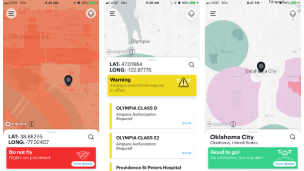
A clear “status” indicator that informs the operator whether it is safe to fly or not. (For example, it shows flying in the Special Flight Rules Area around Washington, D.C. is prohibited.)
-
Informative, interactive maps with filtering options.
-
Information about controlled airspace, special use airspace, critical infrastructure, airports, national parks, military training routes and temporary flight restrictions.
-
The ability to check whether it is safe to fly in different locations by searching for a location or moving the location pin.
-
Links to other FAA drone resources and regulatory information.
By definition, “the app provides situational awareness to recreational flyers and other drone users. It does not allow users to obtain airspace authorizations to fly in controlled airspace, which are only available through the FAA’s Low Altitude Authorization and Notification Capability (LAANC).”
The new app meets the FAA’s goals, and almost all users agree that the app offers a major improvement over the previous app. Few reviews that I found questioned the apps reliability or usability. Many users and reviewers complain, however, about the lack of LAANC functionality – and wonder why they would need B4UFLY in the first place.
The Official App is Designed for All Levels of Flyers – and it’s Anonymous
Drone users are accustomed to being spoiled for choice in respect to airspace intelligence, and experienced pilots may not have considered the total audience for the B4UFLY app. B4UFLY is designed for recreational flyers of all levels of experience, including the family getting a recreational drone for the very first time – and for that purpose, it must first and foremost be simple, easy to use and provide a clear go/no-go answer to pilots. It’s supposed to encourage pilots who right now may not even have considered checking to see what type of airspace they are in to do so – and learn more about the rules of the airspace in the process.
B4UFLY is also designed to be anonymous – removing one barrier to use. When it comes to requesting airspace approval through LAANC, Kittyhawk’s Jon Heagranes writes, “It’s important to note that B4UFLY doesn’t collect personal information or require users to register or login to use the app. By definition, this means that features like LAANC cannot be built directly into B4UFLY (as so many of you have inquired)…” Users who want to request airspace approval through LAANC are directed in the B4UFly App to the Kittyhawk app, which will allow the user to perform the function: but for recreational users who may not even understand the rules and concepts behind airspace authorization, B4UFly provides a big red Do Not Fly to let them know they’ll need to fly elsewhere.
While expert pilots who want to request authorizations are probably already using the Kittyhawk, AirMap, or another airspace intelligence app on the market, B4UFLY is getting plenty of use. Over 700,000 airspace status checks in the very short time that the new app has been available is an impressive number – and, says Hegranes, “We’ve also heard from non-drone pilots that the new intuitive app design is helping them to understand if it’s ok for drones to be flying around them.”
What’s Next?
Kittyhawk says that more features and functionality are in the works for the B4UFLY App. “With our commitment to Remote ID, we’ll be adding in more functionality to B4UFLY to help both the operator and viewer audiences of the application,” writes Hegranes.
“We’re also making advances to modernize and augment airspace data sources to be able to provide more detail and situational awareness. These improvements will be felt by B4UFLY users, and will also benefit all stakeholders of the National Airspace System (NAS).”
For now, the app focuses on FAA airspace regulations. But Kittyhawk says that they are working on also integrating local regulations. “Other local rules may apply to landing, takeoff, and where the operator is standing during flight,” write Hegranes. “This means there isn’t one simple compliance answer for an entire drone operation, but we’re working to highlight these distinctions for safer flight.”
While B4UFLY may not be a perfect solution for everyone, it’s a huge improvement and a step in the right direction for the FAA. Right now it doesn’t allow experienced flyers to apply for LAANC authorization – but it may prevent an inexperienced flyer from providing the next headline about “clueless, careless or criminal” drone pilots.
The new B4UFLY app is now available to download for free at the App Store for iOS and Google Play store for Android.

Miriam McNabb is the Editor-in-Chief of DRONELIFE and CEO of JobForDrones, a professional drone services marketplace, and a fascinated observer of the emerging drone industry and the regulatory environment for drones. Miriam has penned over 3,000 articles focused on the commercial drone space and is an international speaker and recognized figure in the industry. Miriam has a degree from the University of Chicago and over 20 years of experience in high tech sales and marketing for new technologies.
For drone industry consulting or writing, Email Miriam.
TWITTER:@spaldingbarker
Subscribe to DroneLife here.


[…] development partner Kittyhawk is releasing a new version of the B4UFLY app. The newest version adds localized advisories and crowdsourcing for the U.S. drone […]