• Skip to main content
  • Skip to secondary menu
  • Skip to primary sidebar
  • Skip to secondary sidebar
  • Skip to footer
  • DroneRacingLife
  • DroneFlyers
  • Newsletter
DroneLife

DRONELIFE

Stay up to date on all the latest Drone News

  • News
  • Products
  • Industries
    • Agriculture
    • Construction
    • Delivery
    • Dual Use
    • Inspection
    • Public Safety
    • Surveying
  • Enthusiasts
  • Regulations
  • Business
  • Video
  • Podcasts

Drones Document the Devastation in the Bahamas – Images and Video from Above

September 11, 2019 by Miriam McNabb 4 Comments

Just before Hurricane Dorian hit, we had the opportunity to speak with Christopher Todd of the Airborne International Response Team, a volunteer organization of drone pilots and operators working with first responders.  Now, Todd and AIRT share an inside look at their mission in the Bahamas, including stunning images of Dorian’s devastation.

 Joint recon operations between AIRT and SEFL-R7 AHIMT highlights improved capabilities of unmanned aircraft systems for disaster response

 ABACO ISLANDS, BAHAMAS – As the death toll continues to climb in the aftermath of Hurricane Dorian’s September 1 landfall on the Abaco Islands in The Bahamas, professional All Hazards and emergency management teams from the private and public sectors have come together to use aerial drones combined with cutting-edge rapid mapping technology to assess damage and offer situational awareness to local Bahamian government officials.

Members of the Airborne International Response Team (AIRT), a Miami-based 501(c) non-profit organization that provides unmanned aircraft system (UAS) capabilities for disaster response, teamed up with members of the Southeast Florida Region 7 All-Hazards Incident Management Team (SEFL-R7 AHIMT), a professional All Hazards disaster and emergency management team based out of Southeast, Florida, to form a joint-reconnaissance team to survey damage across the hardest hit areas of the Grand Bahama and the Abaco Islands in the Northern Bahamas.

Operating out of Palm Beach International airport, the team was able to secure private air transportation to the various islands they visited.  Starting in Nassau, the team witnessed the escalating response to the disaster which included the deployment of some U.S.-based Urban Search and Rescue (USAR) teams aboard U.S. military aircraft, as well as an army of other non-profit groups rushing in to provide much needed assistance.

After coordinating with the Bahamian government, the team proceeded to Freeport where they helped unload essential supplies including a school bus filled with newly arrived cases of water, tarps, and general supplies for the relief effort.  The team then departed to conduct damage assessment operations with aerial drones at the University of the Bahamas – Northern Campus, and nearby neighborhoods which were hit hardest by Dorian’s fury.
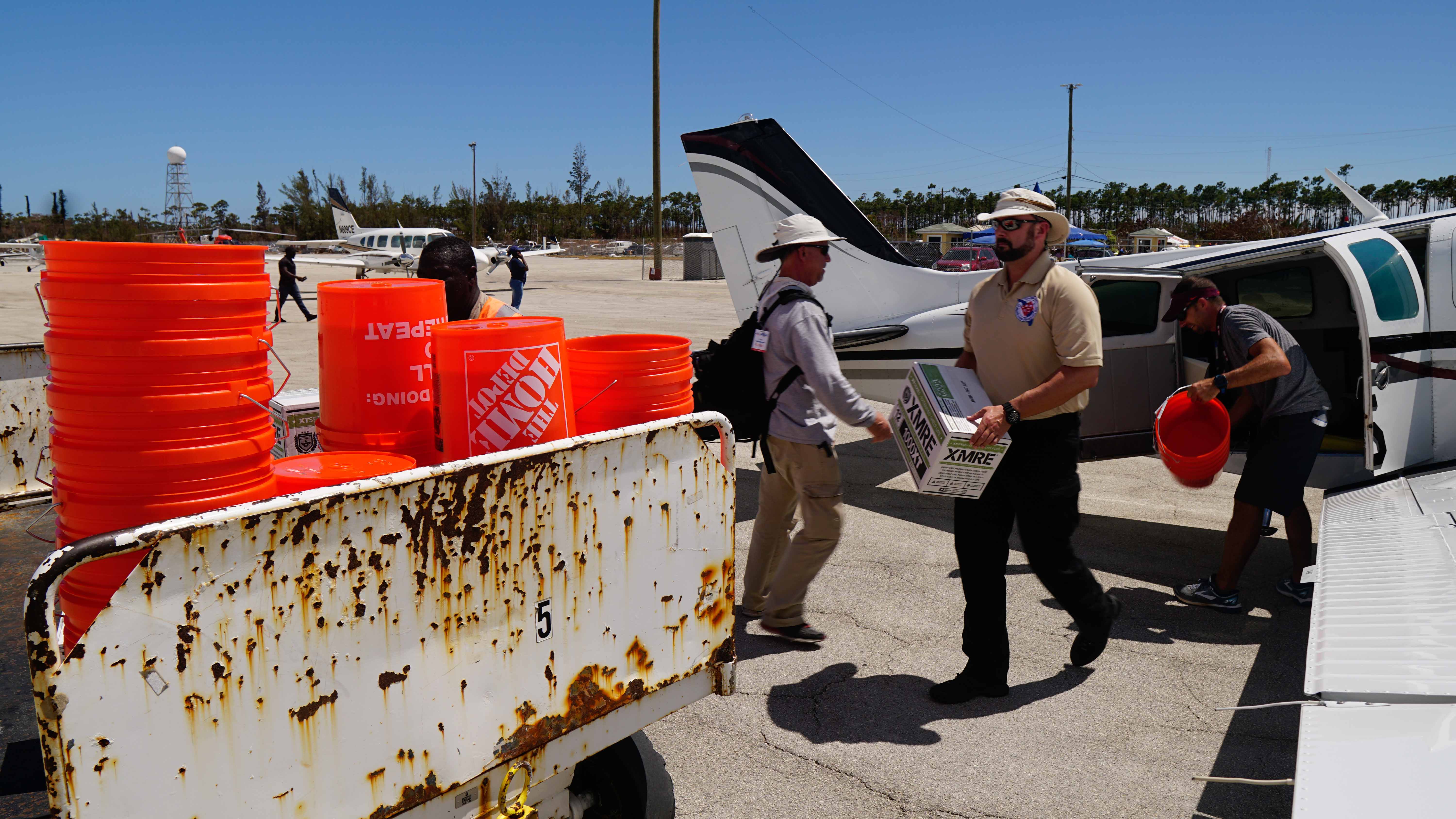
FREEPORT, BAHAMAS – Steve Hynes, Deputy Incident Commander for the Southeast Florida Region 7 All-Hazards Incident Management Team, unloads a case of ready to eat meals (MRE’s) from a recently arrived airplane transporting emergency supplies from West Palm Beach, Florida in the aftermath of Hurricane Dorian. Credit: AIRT

“We saw first-hand the damage that this hurricane leveled upon the Bahamas,” said Nigel Baker, Team Coordinator and Incident Commander of SEFL-R7 AHIMT.  “The combination of massive storm surge and fierce Category 5 winds was more than most structures could bare, no matter what code they were built under.”

At its peak, Dorian’s sustained winds were marked at 185 miles-per-hour, gusting up to 220mph, according to the National Hurricane Center in Miami.  The storm surge over some parts of The Bahamas is projected to have been higher than 20-feet, according to local Bahamian officials.
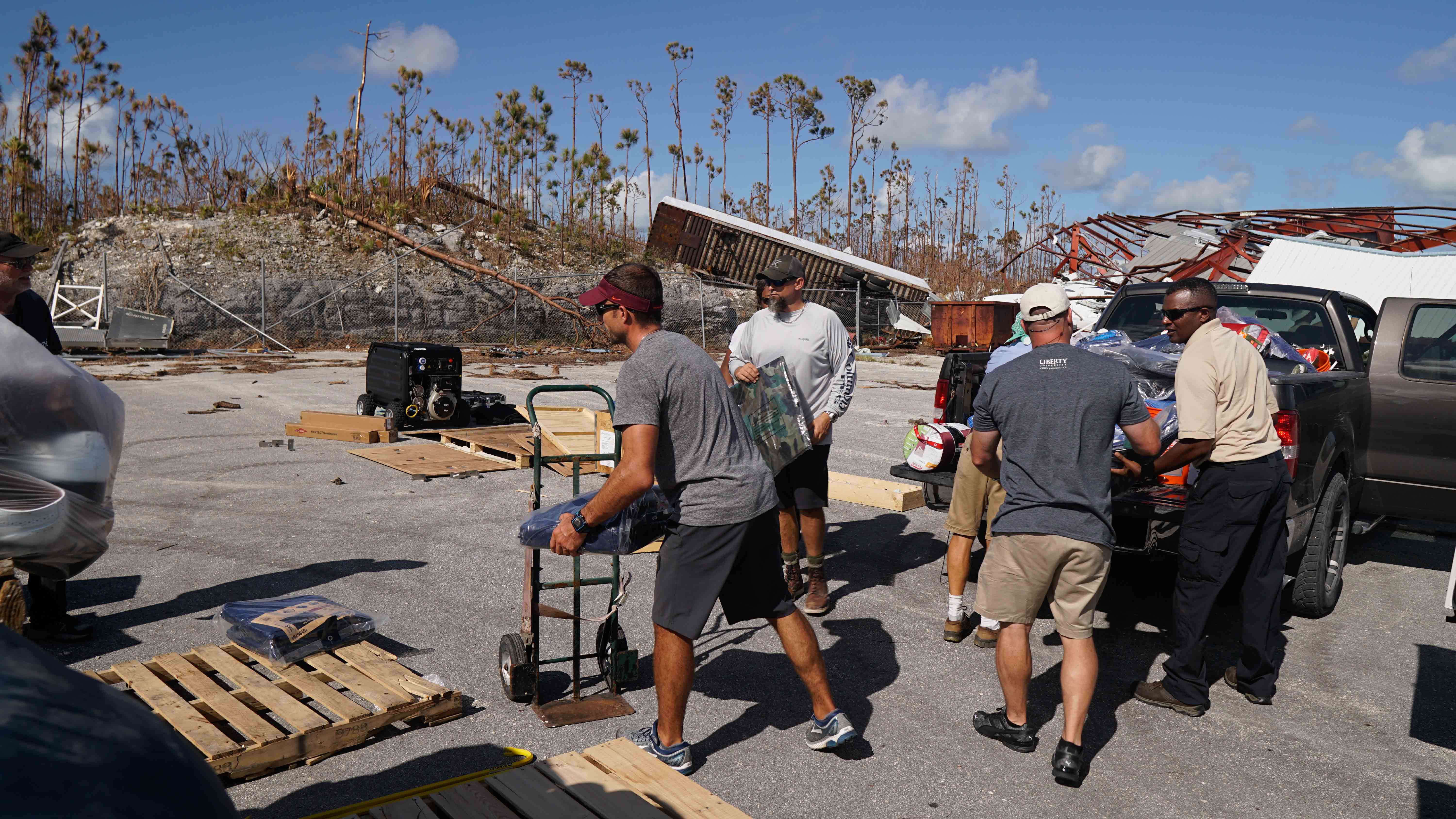
MARSH HARBOR, BAHAMAS – Nigel Baker, Incident Commander for the Southeast Florida Region 7 All-Hazards Incident Management Team, helps local residents stack recently arrived emergency supplies in the aftermath of Hurricane Dorian. Credit: AIRT

One tool the recon team brought with them was an unmanned aircraft system (UAS) – also known as a “drone.”  These aerial systems manned with high-resolution camera systems are helping to map disaster scenes in new ways never before imaginable.

“The debris field at Marsh Harbor was unlike anything I have ever seen,” according to Christopher Todd, Executive Director, AIRT.  “By combining the drone with the latest rapid mapping technology, we were able to produce a highly accurate and incredibly detailed digital map of the hardest hit areas of Marsh Harbor and other the towns.”

MARSH HARBOR, BAHAMAS – Drone imagery shows brightly colored homes crumpled in a cluster of ruin after the fury of Hurricane Dorian’s landfall in the Abaco Islands. Credit: AIRT


MARSH HARBOR, BAHAMAS – Drone imagery shows brightly colored homes and shipping containers strewn across the landscape after the fury of Hurricane Dorian’s landfall in the Abaco Islands. Credit: AIRT

Todd says this type of solution will soon be in use by search and rescue teams around the world when responding to disasters like Dorian.

“Beyond just search and rescue and damage assessment missions, these types of systems will help us provide a better understanding of what exactly happened, why it happened, and how it might be prevented from happening again in the future,” according to Todd.

“This new technology is quickly providing new capabilities for emergency managers,” offers Baker. “More detailed information coming in quicker than ever before will allow us to make better decisions that will ultimately help save more lives.”

For now, the team will continue to provide requested support to The Bahamas as their capabilities and authority allows.  However, the 2019 hurricane season is not over.  Danger is lurking as more tropical systems taunt the Caribbean and U.S. East Coast.

“We need to remain vigilant and ready to respond to the next big storm,” says Baker.  “We’ll take what we have learned in the Bahamas, continue training, and put this new technology to good use once again when it is most needed.”

About AIRT

AIRT® (Airborne Incident Response Team) is a Florida-registered 501(c)3 non-profit organization that provides innovative aviation and aerospace resources to help prepare for, respond to, and recover from complex emergencies and major disasters. AIRT is building the World’s Largest Air Force® for #aviationforgood. Our global remote pilot network is ready to #getup whenever disaster strikes.  For more information, visit: http://airt.ngo

About Southeast Florida Region 7 All-Hazards Incident Management Team,

The Southeast Florida Region 7 All-Hazards Incident Management Team (SEFL-R7 AHIMT) serves as the forward coordinating element for the Florida State Emergency Response Team (SERT) and the State Coordinating Officer (SCO). Headquartered at Palm Beach County Fire Rescue, SEFL-R7 AHIMT will assist in the coordination of necessary logistical support to the SCO and SERT for forward deployment, situational awareness, Emergency Operations Center (EOC) augmentation, base camp management, and many other emergency management missions.  For more information about SEFL-R7 AHIMT, please visit: https://www.floridadisaster.org/state-eoc/incident-management-teams/regional-team-information/

 

Miriam McNabb

Miriam McNabb is the Editor-in-Chief of DRONELIFE and CEO of JobForDrones, a professional drone services marketplace, and a fascinated observer of the emerging drone industry and the regulatory environment for drones. Miriam has penned over 3,000 articles focused on the commercial drone space and is an international speaker and recognized figure in the industry.  Miriam has a degree from the University of Chicago and over 20 years of experience in high tech sales and marketing for new technologies.
For drone industry consulting or writing, Email Miriam.

TWITTER:@spaldingbarker

Subscribe to DroneLife here.

Filed Under: Drone News Feeds, Featured, News Tagged With: AIRT, drones for emergency response, Hurricane bahamas, hurricane dorian

Reader Interactions

Trackbacks

  1. Droni Come Risposta Alla Gestione Delle Emergenze - Sorveglianza Aerea Territoriale says:
    April 18, 2023 at 4:28 pm

    […] a trovare più velocemente le vittime colpite dal disastro . Recentemente, i  droni sono stati utilizzati per le operazioni di ricerca e soccorso alle Bahamas colpite dall’uragano Dorian. Il team di gestione delle emergenze ha unito le forze […]

    Reply
  2. Drones Document the Devastation in the Bahamas - Images and Video from Above - Angle News says:
    September 11, 2019 at 11:10 am

    […] Source link […]

    Reply
  3. Drones Document the Devastation in the Bahamas – Images and Video from Above | Drone Magazine says:
    September 11, 2019 at 9:42 am

    […] Source […]

    Reply
  4. Drones Doc the Devastation within the Bahamas – Photos and Video from Above - Gadgets Now Website says:
    September 11, 2019 at 9:19 am

    […] Supply hyperlink […]

    Reply

Leave a Reply Cancel reply

Your email address will not be published. Required fields are marked *

Primary Sidebar

LATEST

If Pilots Stop Trusting Safety Broadcasts, What Happens to Universal Conspicuity?

AOPA’s opposition to ADS-B billing highlights a growing issue for both crewed and uncrewed aviation News and Commentary. A new…

Continue Reading If Pilots Stop Trusting Safety Broadcasts, What Happens to Universal Conspicuity?

The Drone Industry’s Battery Problem Has a New Challenger

Factorial Expands Solid-State Drone Battery Partnerships Across Three Continents New collaborations aim to improve drone endurance, power, and cold-weather performance…

Continue Reading The Drone Industry’s Battery Problem Has a New Challenger

Commercial UAV Expo Releases 2026 Conference Program Focused on “Actionable Insights”

Community feedback shapes event agenda centered on real-world drone operations and practical takeaways Commercial UAV Expo has announced its 2026…

Continue Reading Commercial UAV Expo Releases 2026 Conference Program Focused on “Actionable Insights”

US Drone Makers Are Building a Different Kind of Factory

Additive Manufacturing Helps Build Flexibility, Scale, and Supply Chain Resilience At AUVSI’s XPONENTIAL 2026 conference in Detroit, one theme surfaced…

Continue Reading US Drone Makers Are Building a Different Kind of Factory

Pentagon Backs AI Counter-Drone Startup with $500 Million Deal

JITF 401 signs $500 million contract with fast-growing startup By DRONELIFE Features Editor Jim Magill The Pentagon plans to acquire…

Continue Reading Pentagon Backs AI Counter-Drone Startup with $500 Million Deal

Under the Ice: New SYOS Underwater Drone Targets Maritime Security and Antarctic Exploration

SYOS Introduces SU10 Underwater Drone for Multi-Domain Operations New uncrewed underwater vehicle expands company portfolio from air, land, and sea…

Continue Reading Under the Ice: New SYOS Underwater Drone Targets Maritime Security and Antarctic Exploration

Amprius and Matternet Expand Drone Delivery Battery Partnership

Silicon anode battery technology aims to improve range, charging time, and delivery economics for commercial drone operations Battery manufacturer Amprius…

Continue Reading Amprius and Matternet Expand Drone Delivery Battery Partnership

Kansas City Builds a World Cup-Era Drone Defense Network

Airspace Link and regional public safety agencies deploy a shared drone coordination and counter-UAS platform designed to support FIFA World…

Continue Reading Kansas City Builds a World Cup-Era Drone Defense Network

Autel Challenges FCC Covered List Decision, Distances Itself from DJI

Drone maker argues FCC relied on broad assumptions instead of company-specific analysis In a sharply worded filing with the Federal…

Continue Reading Autel Challenges FCC Covered List Decision, Distances Itself from DJI

Terra Drone Deploys Terra A2 Interceptor Drone to Ukraine Frontlines

The Japanese drone company brings its long-range, wide-area air defense platform into Ukrainian service alongside Terra A1 through a joint…

Continue Reading Terra Drone Deploys Terra A2 Interceptor Drone to Ukraine Frontlines

Secondary Sidebar

Footer

SPONSORED

Inspired Flight Gremsy IF800 VIO F1 drones geo week

What Will It Take to Strengthen U.S. Drone Manufacturing? A Conversation with Inspired Flight’s CEO

Global Mapper Mobile data collection

Collection Ground Control Points with Global Mapper Mobile

Military Drone Mapping Solutions

How SimActive’s Correlator3D™ is Revolutionizing Military Mapping: An Exclusive Interview with CEO Philippe Simard

Photogrammetry Accuracy Standards

SimActive Photogrammetry Software: Enabling Users to Meet Accuracy Standards for Over 20 Years

NACT Engineering Parrot ANAFI tether indoor shot

Smart Tether for Parrot ANAFI USA from NACT Engineering

Blue Marble, features global mapper, features Blue Marble

Check Out These New Features in Global Mapper v25 from Blue Marble

About Us | Contact Us | Advertise With Us | Write for Us | Privacy Policy | Terms of Service

The Trusted Source for the Business of Drones.

This website uses cookies and third party services. By clicking OK, you are agreeing to our privacy policy. ACCEPT

Manage consent

Privacy Overview

This website uses cookies to improve your experience while you navigate through the website. Out of these, the cookies that are categorized as necessary are stored on your browser as they are essential for the working of basic functionalities of the website. We also use third-party cookies that help us analyze and understand how you use this website. These cookies will be stored in your browser only with your consent. You also have the option to opt-out of these cookies. But opting out of some of these cookies may affect your browsing experience.
Necessary
Always Enabled
Necessary cookies are absolutely essential for the website to function properly. These cookies ensure basic functionalities and security features of the website, anonymously.
CookieDurationDescription
cookielawinfo-checkbox-analytics11 monthsThis cookie is set by GDPR Cookie Consent plugin. The cookie is used to store the user consent for the cookies in the category "Analytics".
cookielawinfo-checkbox-functional11 monthsThe cookie is set by GDPR cookie consent to record the user consent for the cookies in the category "Functional".
cookielawinfo-checkbox-necessary11 monthsThis cookie is set by GDPR Cookie Consent plugin. The cookies is used to store the user consent for the cookies in the category "Necessary".
cookielawinfo-checkbox-others11 monthsThis cookie is set by GDPR Cookie Consent plugin. The cookie is used to store the user consent for the cookies in the category "Other.
cookielawinfo-checkbox-performance11 monthsThis cookie is set by GDPR Cookie Consent plugin. The cookie is used to store the user consent for the cookies in the category "Performance".
viewed_cookie_policy11 monthsThe cookie is set by the GDPR Cookie Consent plugin and is used to store whether or not user has consented to the use of cookies. It does not store any personal data.
Functional
Functional cookies help to perform certain functionalities like sharing the content of the website on social media platforms, collect feedbacks, and other third-party features.
Performance
Performance cookies are used to understand and analyze the key performance indexes of the website which helps in delivering a better user experience for the visitors.
Analytics
Analytical cookies are used to understand how visitors interact with the website. These cookies help provide information on metrics the number of visitors, bounce rate, traffic source, etc.
Advertisement
Advertisement cookies are used to provide visitors with relevant ads and marketing campaigns. These cookies track visitors across websites and collect information to provide customized ads.
Others
Other uncategorized cookies are those that are being analyzed and have not been classified into a category as yet.
SAVE & ACCEPT