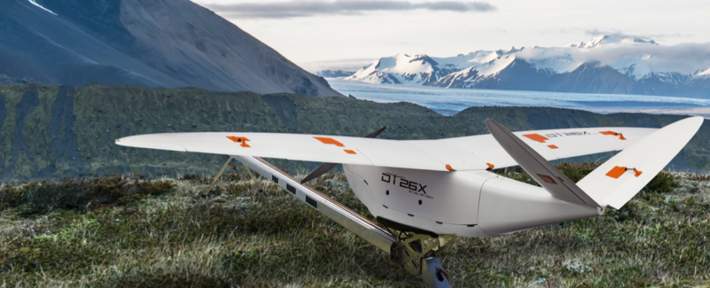
Founded in France, Delair has had the advantage of legally flying beyond visual line of sight (BVLOS) since 2012. Working with regulators and large industrial enterprises – like leading energy companies – Delair has been able to develop a deep hardware and software solution for the enterprise, with long-range drones as a primary tool.
The new Delair DT26X LiDAR UAV, says the company, is “the industry’s first long-range fixed wing drone to combine highly accurate Light Distance and Ranging (LiDAR) sensing capabilities with an integrated high resolution RGB (red, green, blue) camera, dramatically increasing the precision, efficiency and cost effectiveness of surveying and 3D mapping.” The company released details of the new model at the International Lidar Mapping Forum in Denver.
Highly accurate LiDAR sensors are a valuable tool in mapping and surveying, providing detailed data on elevation even in vegetated areas. But they generally need to be used with other imagery to form an accurate 3D model, typically requiring multiple flights with separate drones – one to carry LiDAR and one to carry and RGB camera. The advantages to carrying both are clear.
“The Delair DT26X LiDAR’s combined payload of a lightweight sensor and integrated camera allows the acquisition of LiDAR and photogrammetry data in a single flight, which drastically reduces cost and immediately provides an extremely detailed digital model of the inspected assets,” says Delair. “The LiDAR sensor is specifically designed for UAV use, adding little weight or bulk to the Delair frame. The fully-integrated smart RGB camera enables real-time camera sensor control and in-flight photo review with automated quality checks.”
“The new platform delivers increased accuracy in 3D mapping and modeling of terrain and corridors in challenging physical environments (e.g. mountainous, inaccessible by road or foot, dense vegetation) and with difficult visibility, lighting or weighting conditions. Its long range flying capabilities – allowing coverage of up to 2,400 square acres, communication range of 30 kilometers and 100 minutes of flight time – improve the efficiency of aerial mapping operations over large areas,” says a company release.
“The combination of a sophisticated LiDAR sensor and an industrial grade RGB camera removes the ‘either/or’ decision of choosing between LiDAR and imagery data acquisition for geospatial professionals. This is the most versatile and cost-effective UAV solution for large area, long range mapping and surveying where accuracy and detail are required,” said Chase Fly, Geospatial Product Manager at Delair. “It provides the precision and visibility required by the most demanding use cases and allows data acquisition and advanced digitization not possible through terrain-based or satellite 3D mapping techniques, or with limited short-range UAVs. With this configuration, users can acquire all the data required for a colorized point cloud from a single flight, which eases the point cloud classification process back in the office, saving significant time and money.”
The New Sensor
Delair DT26X LiDAR is the first fixed wing UAV to incorporate the new RIEGL miniVUX-1DL LiDAR sensor, a specially designed device for the needs of UAV use. The small form factor sensor includes a downward looking and optimized field of view specifically geared for corridor mapping tasks. The wedge prism scanner construction produces a field of view of 46°, and the circular scan pattern provides a very high point density and point distribution.
It offers a high scan speed of up to 150 scans/sec and a measurement rate of up to 100,000 measurements/sec. It is effective in penetrating poor lighting conditions or dense foliage. The LiDAR sensor makes use of RIEGL’s unique Waveform-LiDAR technology, allowing echo digitization and online waveform processing. It supports multiple-target resolution – up to five target echoes per laser shot.
“The new Delair UAV is typically the type of drone RIEGL had in mind when designing the RIEGL miniVUX-1DL, and represents another step toward completing our UAV LiDAR equipment product portfolio. The scanner’s specific wedge prism scanning mechanism generates a circular scan pattern, resulting in high point densities and therefore is especially well suited when deploying the scanner from fast moving acquisition platforms such as fixed-wing UAVs. The FOV (Field of View) of the miniVUX-1DL is 46deg, resulting in optimized efficiency for downward-looking, linear acquisition set-ups like corridor mapping applications, for example. We are pleased to have such an innovative company like Delair as an esteemed OEM integration partner, bringing our sensing technology to key market sectors that require a flexible LiDAR solution,” commented Michael Mayer, Managing Director, RiCOPTER UAV GmbH.
Miriam McNabb is the Editor-in-Chief of DRONELIFE and CEO of JobForDrones, a professional drone services marketplace, and a fascinated observer of the emerging drone industry and the regulatory environment for drones. Miriam has penned over 3,000 articles focused on the commercial drone space and is an international speaker and recognized figure in the industry. Miriam has a degree from the University of Chicago and over 20 years of experience in high tech sales and marketing for new technologies.
For drone industry consulting or writing, Email Miriam.
TWITTER:@spaldingbarker
Subscribe to DroneLife here.