• Skip to main content
  • Skip to secondary menu
  • Skip to primary sidebar
  • Skip to secondary sidebar
  • Skip to footer
  • DroneRacingLife
  • DroneFlyers
  • Newsletter
DroneLife

DRONELIFE

Stay up to date on all the latest Drone News

  • News
  • Products
  • Industries
    • Agriculture
    • Construction
    • Delivery
    • Dual Use
    • Inspection
    • Public Safety
    • Surveying
  • Enthusiasts
  • Regulations
  • Business
  • Video
  • Podcasts

Inkonova’s Drone Can Fly, Roll & Climb to Map Underground

October 2, 2017 by Malek Murison 4 Comments

We’ve heard plenty about the potential of drones when it comes to the mining industry. But more often than not these applications are associated with mapping, modelling, tracking the progress of operations and measuring stockpiles or inventory above ground. A lesser known use for drones is exploration below the surface. Swedish startup Inkonova is leading the way in this field, with a unique drone named the Tilt Ranger.

So how do you explore vast underground caverns without the use of GPS? How do you scan underground mines quickly and safely in the darkness? The answer, according to Inkonova, is Tilt Ranger, a drone that comes with wheels. Or a land vehicle that comes with props, depending on your viewpoint.

inkonova: the tilt ranger drone for underground mining

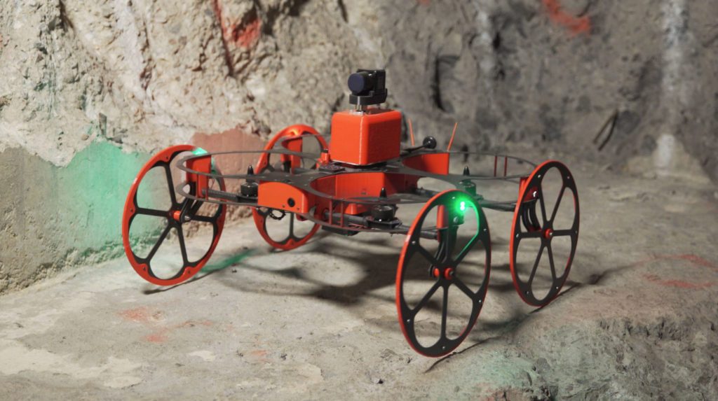
Its rugged design allows the Tilt Ranger to get around and adapt to its environment. The rotors are protected by carbon fibre covers, while oversized wheels allow it to roll along ground even over inclined, uneven surfaces. Essentially, the Tilt Ranger can run, climb and fly. Its rotors can tilt to support its movement or carry the drone’s full weight.

With 20 minutes of flight time and three First Person View (FPV), low lux, cameras for dark environments, the pilot can use an on-screen display to see what’s going on even in dark, dangerous and hard-to-reach scenarios.

But having a view of the surroundings is just the beginning. The Tilt Ranger carries a 1kg laser scanner and utilizes a technique called SLAM to calculate distances and develop an accurate map of the environment.

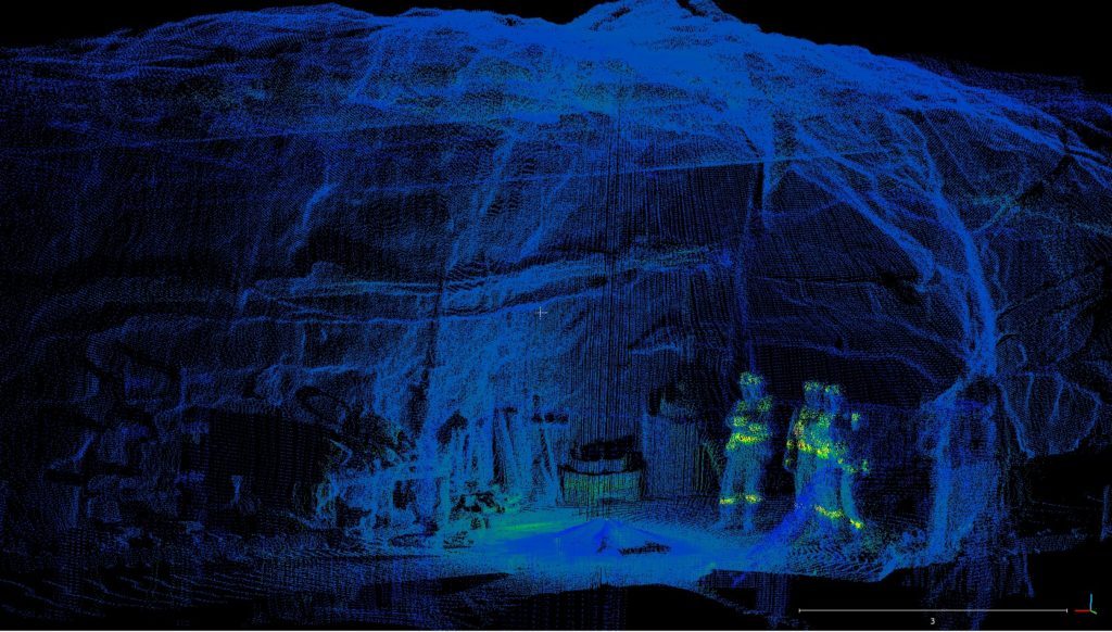
Inkonova recently put the Tilt Ranger to the test to map an underground mine in Mali. In just 10 minutes, the team was able to virtually reconstruct a section of the mine with a volume of roughly 30,000 cubic metres. “It’s not a big challenge to capture such zones quickly,” said co-founder Ahmed AlNomany, speaking with New Scientist.

Unsurprisingly, Inkonova’s drones gaining attention beyond the world of mining. In the future, there are plans to put the Tilt Ranger to use to help decommission nuclear power plants. Despite turning down a nuclear opportunity because of fears over how the propellers would cope with exposure to radiation, the team has not yet been defeated on that front. “We didn’t pursue it further, but we would like to adapt Tilt Ranger for this purpose,” says AlNomany.

Developing an autonomous navigation system in GPS-deprived, low-light environments

One of Inkonova’s main goals is to develop a system that allows its drones to work autonomously in underground situations. The team is currently developing an autonomous navigation system for aerial drones to operate despite three constraints: “GPS-deprived, light-deprived and space-tight environments.”

Inkonova

The exploratory potential of such technology would go way beyond mining.

Malek Murison
Malek Murison

Malek Murison is a freelance writer and editor with a passion for tech trends and innovation. He handles product reviews, major releases and keeps an eye on the enthusiast market for DroneLife.
Email Malek
Twitter:@malekmurison

Subscribe to DroneLife here.

Filed Under: Amazing Footage, Applications, Drone News Feeds, Mining and Aggregates, News, Products, Technology, Video Tagged With: inkonova, Mining, tilt ranger

Reader Interactions

Trackbacks

  1. Inkonova’s Drone Can Fly, Roll & Climb to Map Underground - Drone Services Company | Aerial Photo and Video | Miami Florida says:
    October 3, 2017 at 6:49 am

    […] post Inkonova’s Drone Can Fly, Roll & Climb to Map Underground appeared first on […]

    Reply
  2. Inkonova’s Drone Can Fly, Roll & Climb to Map Underground – Drone Magazine says:
    October 3, 2017 at 2:50 am

    […] Source […]

    Reply
  3. Inkonova’s Drone Can Fly, Roll & Climb to Map Underground | News and Reviews about Drones, Quadcopter, Camera says:
    October 3, 2017 at 12:35 am

    […] Source link […]

    Reply
  4. Inkonova’s Drone Can Fly, Roll & Climb to Map Underground – Dronegram says:
    October 2, 2017 at 8:25 pm

    […] post Inkonova’s Drone Can Fly, Roll & Climb to Map Underground appeared first on […]

    Reply

Leave a Reply Cancel reply

Your email address will not be published. Required fields are marked *

Primary Sidebar

LATEST

Digital Force Technologies and Powerus Build Full-Stack Counter-UAS Kill-Chain

Digital Force Technologies (DFT) and Powerus have announced a strategic partnership to deliver a fully integrated counter-UAS kill-chain. The system…

Continue Reading Digital Force Technologies and Powerus Build Full-Stack Counter-UAS Kill-Chain

COUNTER Act and Secure Our Skies: New Mexico Congressman Pushes New Drone Bills

By Dronelife Features Editor Jim Magill As the widespread use of UAVs proliferates across the country, along with the inherent…

Continue Reading COUNTER Act and Secure Our Skies: New Mexico Congressman Pushes New Drone Bills

Pentagon Filing Opposes DJI Petition, Citing National Security Risks and Classified Information

Department of Defense submission to FCC reinforces concerns over foreign-made drone technology A newly filed memorandum from the U.S. Department…

Continue Reading Pentagon Filing Opposes DJI Petition, Citing National Security Risks and Classified Information

Africa’s Drone Manufacturing Push Signals a New Global Supply Chain

Nigeria-based Terra Industries scales production with backing from U.S. investors, pointing to a third path beyond the U.S. and China…

Continue Reading Africa’s Drone Manufacturing Push Signals a New Global Supply Chain

ePropelled Expands Hercules Starter Generator Line With Scalable Hybrid Power for Drones

ePropelled has announced a major 2026 expansion of its Hercules starter generator product line. The update targets hybrid drone propulsion…

Continue Reading ePropelled Expands Hercules Starter Generator Line With Scalable Hybrid Power for Drones

Inside the Coachella Valley’s Plan to Centralize Drone First Responder Operations

By Dronelife Features Editor Jim Magill The Palm Springs, California Police Department is taking its Drones as First Responders (DFR)…

Continue Reading Inside the Coachella Valley’s Plan to Centralize Drone First Responder Operations

Teledyne FLIR OEM Upgrades Prism SKR Software for Autonomous Target Recognition

New release combines mission execution and intelligent supervision in a single autonomy platform Teledyne FLIR OEM has announced an upgrade…

Continue Reading Teledyne FLIR OEM Upgrades Prism SKR Software for Autonomous Target Recognition

Drone Operations Software Company AirHub Closes €4.4M Series A

AirHub, a European drone operations software company based in The Hague, has closed a €4.4 million Series A funding round.…

Continue Reading Drone Operations Software Company AirHub Closes €4.4M Series A

Arrive AI Patents Shared Drone Delivery Endpoint With Tenth U.S. Patent

Arrive AI (NASDAQ: ARAI) has secured its tenth U.S. patent, strengthening its intellectual property portfolio for autonomous drone delivery infrastructure.…

Continue Reading Arrive AI Patents Shared Drone Delivery Endpoint With Tenth U.S. Patent

Korean eVTOL Developer Airbility Partners on UAV Public Safety in Thailand

South Korean eVTOL developer Airbility has signed a four-party Memorandum of Understanding to deploy UAV systems for public safety and…

Continue Reading Korean eVTOL Developer Airbility Partners on UAV Public Safety in Thailand

Secondary Sidebar

Footer

SPONSORED

Inspired Flight Gremsy IF800 VIO F1 drones geo week

What Will It Take to Strengthen U.S. Drone Manufacturing? A Conversation with Inspired Flight’s CEO

Global Mapper Mobile data collection

Collection Ground Control Points with Global Mapper Mobile

Military Drone Mapping Solutions

How SimActive’s Correlator3D™ is Revolutionizing Military Mapping: An Exclusive Interview with CEO Philippe Simard

Photogrammetry Accuracy Standards

SimActive Photogrammetry Software: Enabling Users to Meet Accuracy Standards for Over 20 Years

NACT Engineering Parrot ANAFI tether indoor shot

Smart Tether for Parrot ANAFI USA from NACT Engineering

Blue Marble, features global mapper, features Blue Marble

Check Out These New Features in Global Mapper v25 from Blue Marble

About Us | Contact Us | Advertise With Us | Write for Us | Privacy Policy | Terms of Service

The Trusted Source for the Business of Drones.

This website uses cookies and third party services. By clicking OK, you are agreeing to our privacy policy. ACCEPT

Manage consent

Privacy Overview

This website uses cookies to improve your experience while you navigate through the website. Out of these, the cookies that are categorized as necessary are stored on your browser as they are essential for the working of basic functionalities of the website. We also use third-party cookies that help us analyze and understand how you use this website. These cookies will be stored in your browser only with your consent. You also have the option to opt-out of these cookies. But opting out of some of these cookies may affect your browsing experience.
Necessary
Always Enabled
Necessary cookies are absolutely essential for the website to function properly. These cookies ensure basic functionalities and security features of the website, anonymously.
CookieDurationDescription
cookielawinfo-checkbox-analytics11 monthsThis cookie is set by GDPR Cookie Consent plugin. The cookie is used to store the user consent for the cookies in the category "Analytics".
cookielawinfo-checkbox-functional11 monthsThe cookie is set by GDPR cookie consent to record the user consent for the cookies in the category "Functional".
cookielawinfo-checkbox-necessary11 monthsThis cookie is set by GDPR Cookie Consent plugin. The cookies is used to store the user consent for the cookies in the category "Necessary".
cookielawinfo-checkbox-others11 monthsThis cookie is set by GDPR Cookie Consent plugin. The cookie is used to store the user consent for the cookies in the category "Other.
cookielawinfo-checkbox-performance11 monthsThis cookie is set by GDPR Cookie Consent plugin. The cookie is used to store the user consent for the cookies in the category "Performance".
viewed_cookie_policy11 monthsThe cookie is set by the GDPR Cookie Consent plugin and is used to store whether or not user has consented to the use of cookies. It does not store any personal data.
Functional
Functional cookies help to perform certain functionalities like sharing the content of the website on social media platforms, collect feedbacks, and other third-party features.
Performance
Performance cookies are used to understand and analyze the key performance indexes of the website which helps in delivering a better user experience for the visitors.
Analytics
Analytical cookies are used to understand how visitors interact with the website. These cookies help provide information on metrics the number of visitors, bounce rate, traffic source, etc.
Advertisement
Advertisement cookies are used to provide visitors with relevant ads and marketing campaigns. These cookies track visitors across websites and collect information to provide customized ads.
Others
Other uncategorized cookies are those that are being analyzed and have not been classified into a category as yet.
SAVE & ACCEPT