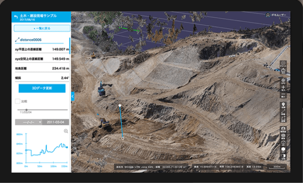
Terra Drone Co., Ltd. headquartered in Shibuya-ku, Tokyo, have launched their image processing software “Terra Mapper” designed to assist drone surveying services. Terra Mapper is an automated drone navigation, image processing, and 3D image analysis program that is available in both cloud and desktop versions. It enables users to accurately inspect the 2D & 3D data images produced by their nominated drone service, allowing effective analysis at a more cost-efficient price.
Key features of Terra Mapper Cloud include:
- For all data processing and management, the software does not have to be installed on a desktop. Access to the internet on PC, tablet, smart phones or other devices will have your organization immediately connected.
- In Terra Mapper Cloud, we offer construction management tools to monitor the numerical change in components such as soil volumes and elevation levels at the site. The data is also readily available, so they be used as reference materials on and off the site.
- Terra Mapper Cloud is a platform for sharing information between project members. In addition sharing information and incorporating a chat function, you can also delegate tasks, allocate the placement of equipment and monitor the progress of the site.
Terra Mapper Desktop key features
- By automatically recognizing anti-aircraft sign, time can be spent on obtaining more accurate data.
- More accurate topographical data can be measured by displaying and automatically eliminating the unnecessary components on site including construction equipment and foliage in the field. Ultimately allowing an accurate detection of soil to be removed, the amount of soil and cross sections of the land.
- Creates cross sectional diagrams simply while evenly spacing with the center line of the figure.
- To simplify the calculation of embankments and cutting and also TIN Surface (Triangulated irregular network) It is possible to create one.
Pricing, availability, and which drones the software is compatible were not released. An update will be posted when and if that information becomes available. You can learn more about the company and its products here.
Frank Schroth is editor in chief of DroneLife, the authoritative source for news and analysis on the drone industry: it’s people, products, trends, and events.
Email Frank
TWITTER:@fschroth