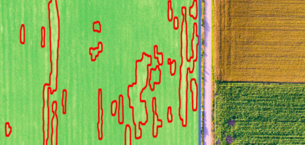
IntelinAir has announced the release of an analytics engine for high-resolution aerial imagery of agricultural fields. In a release the company writes that last year their AgMRI engine analyzed over 50 TB of imagery from millions of acres of corn and soybean fields in Illinois and Iowa. This analysis alerted growers to issues impacting yields and input decisions.
“We’re excited to give farmers an early-warning system and actionable insights,” said Al Eisaian, Co-founder and CEO of IntelinAir. “No one wants to be swamped with data, so our partners appreciate that IntelinAir’s expert scientists have created an automated system for processing millions of images to find specific, actionable problems that growers can address quickly and efficiently during the growing season.”
IntelinAir uses manned airplane flights to capture imagery at “to-the-plant” resolution on the order of centimeters per pixel—far superior to what is available by satellite—leveraging visible, near infrared and thermal cameras. The system then uses sophisticated computer vision and machine learning algorithms to detect abnormalities like weeds, uneven emergence, nutrient deficiencies, disease/insect infestations, water damage, equipment problems and more so that farmers can address issues quickly and understand the impact on yield.
“With IntelinAir, as a grower I know where to focus my attention on problem areas across my farm,” said Corey Holmes, Holmes Farms, New Holland, IL. “It provides a game-changing level of detail and opportunity to make decisions earlier and more efficiently than ever before.”
IntelinAir will be offering demonstrations of its AgMRI product at the 2017 InfoAg Conference, July 25-27, in St. Louis, and growers will have a chance to sign up for the 2018 season. Visitors can also learn more or request a demo at IntelinAir.com.
Frank Schroth is editor in chief of DroneLife, the authoritative source for news and analysis on the drone industry: it’s people, products, trends, and events.
Email Frank
TWITTER:@fschroth


[…] post IntelinAir Announces Analytics Platform for High-Resolution Aerial Imagery appeared first on […]