• Skip to main content
  • Skip to secondary menu
  • Skip to primary sidebar
  • Skip to secondary sidebar
  • Skip to footer
  • DroneRacingLife
  • DroneFlyers
  • Newsletter
DroneLife

DRONELIFE

Stay up to date on all the latest Drone News

  • News
  • Products
  • Industries
    • Agriculture
    • Construction
    • Delivery
    • Dual Use
    • Inspection
    • Public Safety
    • Surveying
  • Enthusiasts
  • Regulations
  • Business
  • Video
  • Podcasts

Keep Your Construction Project on Track with Drone Mapping

December 5, 2016 by Frank Schroth 1 Comment

Guest post by DroneDeploy —

Project Managers Use Drone Maps to Communicate with Stakeholders, Monitor Progress and More

More and more, project managers are finding drone mapping to be an indispensable tool during all phases of construction. Easy-to-use software allows them to create high-resolution orthomosaic, elevation and 3D maps in a matter of hours. Combined with built-in measurement tools and annotations, they can keep real-time tabs on projects and identify potential issues before they become costly.

Cloud-based maps make sharing and collaborating with everyone from site engineers to project owners simple. Executives and offsite stakeholders stay informed and, because drone mapping is cost-effective, they see a return-on-investment almost immediately.

Overlay Plans with High-Resolution Maps to Catch Conflicts Sooner

Contract Project Manager Nick Johnson of Tilt Rock of Texas uses drone mapping to manage large, custom home projects. He has been in construction for forty years and a contractor-owner for twenty five years. When he began incorporating drones into his work, he saw immediate savings of both time and money.

As the PM on a custom community with sixty seven homes, Johnson flew his drone over the site weekly and produced high-resolution maps that he overlaid with utility, wastewater and communications plans. Homeowners on this project made frequent changes to house footprints, models and orientation. But these overlays allowed him to stay informed with real-time data, catch conflicts with services before they actually happened and redirect them at minimum cost.

Section of orthomosaic map with overlay shows service conflicts

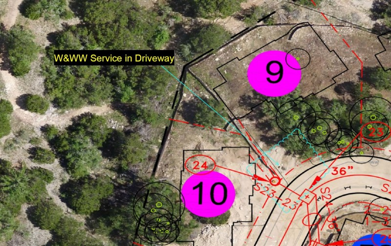
“If it weren’t for the drone maps, it would take me months to find out about many of these changes. Because aerial imagery identifies conflicts I wouldn’t normally see from the ground level, I find out about them in a matter of days.”- Nick Johnson [click to tweet]

Collaborate Virtually and Keep Stakeholders Informed

When a major American construction company built a million-square-foot distribution facility in which the ground was not level, they used drone mapping, combined with DroneDeploy’s measurement tools, to monitor the earth-moving process. The company worked with Uplift Data Partners, a drone services company, to help them capture drone imagery.

Andrew Dennison, COO of Uplift Data Partners, points out that drone mapping greatly improves communication both onsite and off. It is the quickest way to keep offsite stakeholders up to speed. “The project executive doesn’t feel the need to visit the site as often because he has a much better idea of how the site is progressing,” says Dennison.

DroneDeploy’s annotations feature allows project managers to convey information to multiple stakeholders with ease. Because maps are hosted on the DroneDeploy cloud, it is easy to share information through email or a hyperlink. “The construction company execs and the construction clients themselves can much more formally and neatly be updated on the progress.

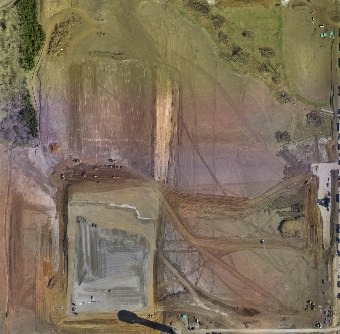
In addition to keeping off-site management informed, the drone maps help PMs keep tabs on their sites more efficiently. DroneDeploy’s suite of high-resolution orthomosaic, 3-D and elevation maps allows them to drill down into key sections of a site. Area, distance and volume measurement tools provide an additional level of detail.

“The site managers don’t need to spend hours walking the site every day — they can check it on the drone imagery.” -Andrew Dennison [click to tweet]

A Cost-Effective Alternative to Surveying

Tumal Karunaratne uses drone mapping as a cost-effective alternative to traditional surveying. Karunaratne is a project engineer with Civil Solutions Associatiates, a geotechnical engineering company. In a matter of hours, he created an elevation map to assess the topography of a property in which the house was showing signs of damage from a landslide.

Elevation map showing the steep hill in blue

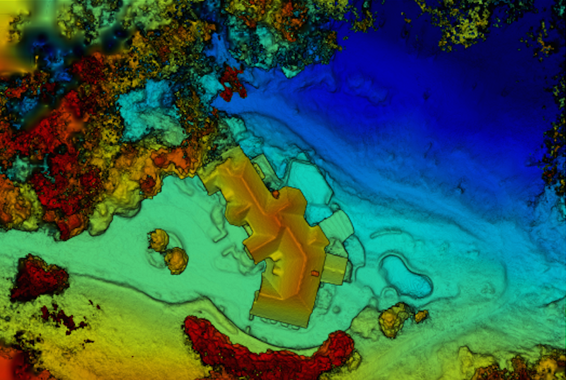
“Site evaluations [with a survey crew] could cost us five or ten thousand dollars…We’d much rather spend two thousand on a DJI drone, fly it ourselves and collect all the data we‘ll need.” -Tumal Karunaratne

Create Buy In from Management Low Entry Cost

For project managers looking to explore if drone mapping is right for their construction sites, Russ Gibbs of construction company Brasfield &Gorrie points out that low entry costs and a high return-on investment mean creating buy in from upper management isn’t difficult.

“The initial cost of drones is very low. You can get a DJI Phantom 4 at your local Apple store, work with DroneDeploy to test, and you’re up and running at a very low entry cost,” says Gibbs. “Because of that, we quickly had enough data to set up a presentation with management and as soon as they saw it, they understood it.”

To hear more from Gibbs, and his partners at Brasfield & Gorrie, about how they are using Drone Mapping to revolutionize their construction sites, watch our webinar: A Drone on Every Job Site: The Recap.

Click to watch the webinar

Frank Schroth
Frank Schroth

Frank Schroth is editor in chief of DroneLife, the authoritative source for news and analysis on the drone industry: it’s people, products, trends, and events.
Email Frank
TWITTER:@fschroth

Filed Under: Applications, Construction, Industries, News Tagged With: DroneDeploy

Reader Interactions

Trackbacks

  1. DroneShield Ltd (ASX:DRO) Top 5 Illegal Ways Drones Get Used | Drone "Ki" says:
    December 28, 2016 at 12:02 am

    […] Guest post by DroneDeploy — Project Managers Use Drone Maps to Communicate with Stakeholders, Monitor Progress and More More and more, project managers are finding drone mapping to be an indispensable tool during all phases of construction. Easy-to-use software allows them to create high-resolution orthomosaic, elevation and 3D maps in a matter of hours. Combined with […] The post Keep Your Construction Project on Track with Drone Mapping appeared first on DRONELIFE. See Original Article […]

    Reply

Leave a Reply Cancel reply

Your email address will not be published. Required fields are marked *

Primary Sidebar

LATEST

Ondas Unveils New Autonomous Counter-Drone and Robotic Combat Systems

MODUS and IRON WAVE aim to help military forces counter drone threats and deploy robotic systems ahead of frontline troop…

Continue Reading Ondas Unveils New Autonomous Counter-Drone and Robotic Combat Systems

Congress Introduces GUARD Act, Extending FCC Covered List Framework to Robotics

Proposed legislation would require national security review of certain foreign-made humanoid and quadruped robots A bipartisan group of lawmakers has…

Continue Reading Congress Introduces GUARD Act, Extending FCC Covered List Framework to Robotics

Blueflite Added to FAA Section 44807 Approved UAS List: Why it Matters

Cargo drone platform joins FAA-reviewed aircraft list, potentially streamlining future operator approvals Michigan-based drone manufacturer blueflite announced that its Cobalt…

Continue Reading Blueflite Added to FAA Section 44807 Approved UAS List: Why it Matters

Aeronext Unveils ActiveWing Logistics Drone Prototype for Long-Range Delivery

This article published in collaboration with JUIDA, the Japan UAS Industrial Development Association.     The Tokyo company’s new multicopter pairs…

Continue Reading Aeronext Unveils ActiveWing Logistics Drone Prototype for Long-Range Delivery

FBI, Atlanta PD Stress Need for ‘No-Drone Zone’ Compliance

By Dronelife Features Editor Jim Magill (Editor’s note: This story is part of a series of reports on efforts to…

Continue Reading FBI, Atlanta PD Stress Need for ‘No-Drone Zone’ Compliance

Building a Resilient Supply Chain: Regional Security Leaders Focus on Industrial Readiness

Northeast National Security Conference examines how the U.S. can strengthen its defense industrial base Supply chain security has become a…

Continue Reading Building a Resilient Supply Chain: Regional Security Leaders Focus on Industrial Readiness

Defense Leaders Call for Faster Paths from Innovation to the Field

Remarks at the Northeast National Security Conference highlight growing demand for rapid, commercially informed defense solutions The 2026 Northeast National…

Continue Reading Defense Leaders Call for Faster Paths from Innovation to the Field

Collective Defence Acquires Asterion in $1 Billion Deal Combining Cybersecurity and Counter-Drone Technology

Transaction creates Luxembourg’s first defense unicorn and brings together cyber defense and combat-tested counter-UAS capabilitie Collective Defence has announced its…

Continue Reading Collective Defence Acquires Asterion in $1 Billion Deal Combining Cybersecurity and Counter-Drone Technology

Vantis BVLOS System Adds New Partner, FAA Waiver Across 5,000 Square Miles

A new FAA aircraft-agnostic waiver lets Frontier Precision fly any NDAA-compliant drone under 55 pounds across more than 5,000 square…

Continue Reading Vantis BVLOS System Adds New Partner, FAA Waiver Across 5,000 Square Miles

MatrixSpace Validated in U.S. Army’s Operation Jailbreak Integration Sprint

The portable radar maker’s integration with Anduril Lattice and IBCS-M passed Army validation at Fort Carson, joining 55 companies in…

Continue Reading MatrixSpace Validated in U.S. Army’s Operation Jailbreak Integration Sprint

Secondary Sidebar

Footer

SPONSORED

Inspired Flight Gremsy IF800 VIO F1 drones geo week

What Will It Take to Strengthen U.S. Drone Manufacturing? A Conversation with Inspired Flight’s CEO

Global Mapper Mobile data collection

Collection Ground Control Points with Global Mapper Mobile

Military Drone Mapping Solutions

How SimActive’s Correlator3D™ is Revolutionizing Military Mapping: An Exclusive Interview with CEO Philippe Simard

Photogrammetry Accuracy Standards

SimActive Photogrammetry Software: Enabling Users to Meet Accuracy Standards for Over 20 Years

NACT Engineering Parrot ANAFI tether indoor shot

Smart Tether for Parrot ANAFI USA from NACT Engineering

Blue Marble, features global mapper, features Blue Marble

Check Out These New Features in Global Mapper v25 from Blue Marble

About Us | Contact Us | Advertise With Us | Write for Us | Privacy Policy | Terms of Service

The Trusted Source for the Business of Drones.

This website uses cookies and third party services. By clicking OK, you are agreeing to our privacy policy. ACCEPT

Manage consent

Privacy Overview

This website uses cookies to improve your experience while you navigate through the website. Out of these, the cookies that are categorized as necessary are stored on your browser as they are essential for the working of basic functionalities of the website. We also use third-party cookies that help us analyze and understand how you use this website. These cookies will be stored in your browser only with your consent. You also have the option to opt-out of these cookies. But opting out of some of these cookies may affect your browsing experience.
Necessary
Always Enabled
Necessary cookies are absolutely essential for the website to function properly. These cookies ensure basic functionalities and security features of the website, anonymously.
CookieDurationDescription
cookielawinfo-checkbox-analytics11 monthsThis cookie is set by GDPR Cookie Consent plugin. The cookie is used to store the user consent for the cookies in the category "Analytics".
cookielawinfo-checkbox-functional11 monthsThe cookie is set by GDPR cookie consent to record the user consent for the cookies in the category "Functional".
cookielawinfo-checkbox-necessary11 monthsThis cookie is set by GDPR Cookie Consent plugin. The cookies is used to store the user consent for the cookies in the category "Necessary".
cookielawinfo-checkbox-others11 monthsThis cookie is set by GDPR Cookie Consent plugin. The cookie is used to store the user consent for the cookies in the category "Other.
cookielawinfo-checkbox-performance11 monthsThis cookie is set by GDPR Cookie Consent plugin. The cookie is used to store the user consent for the cookies in the category "Performance".
viewed_cookie_policy11 monthsThe cookie is set by the GDPR Cookie Consent plugin and is used to store whether or not user has consented to the use of cookies. It does not store any personal data.
Functional
Functional cookies help to perform certain functionalities like sharing the content of the website on social media platforms, collect feedbacks, and other third-party features.
Performance
Performance cookies are used to understand and analyze the key performance indexes of the website which helps in delivering a better user experience for the visitors.
Analytics
Analytical cookies are used to understand how visitors interact with the website. These cookies help provide information on metrics the number of visitors, bounce rate, traffic source, etc.
Advertisement
Advertisement cookies are used to provide visitors with relevant ads and marketing campaigns. These cookies track visitors across websites and collect information to provide customized ads.
Others
Other uncategorized cookies are those that are being analyzed and have not been classified into a category as yet.
SAVE & ACCEPT