• Skip to main content
  • Skip to secondary menu
  • Skip to primary sidebar
  • Skip to secondary sidebar
  • Skip to footer
  • DroneRacingLife
  • DroneFlyers
  • Newsletter
DroneLife

DRONELIFE

Stay up to date on all the latest Drone News

  • News
  • Products
  • Industries
    • Agriculture
    • Construction
    • Delivery
    • Dual Use
    • Inspection
    • Public Safety
    • Surveying
  • Enthusiasts
  • Regulations
  • Business
  • Video
  • Podcasts

Drone Map Saves Insurance Company €99,985,000

July 6, 2016 by Frank Schroth 1 Comment

 Dronotec uses DroneDeploy to provide vital information to insurance companies

Guest post By Anya Lamb, @DroneDeploy

After a disaster, it’s important to clean up and rebuild, but it’s also critical to capture the site as it is so that the damage can be assessed. Drone mapping gives insurance companies a fast, easy way of accurately documenting the scene, preserving key details while letting the process of clean-up and reconstruction begin as quickly as possible.

Emilien Rose, Founder of Dronotec

This case study comes from Emilien Rose, founder of Dronotec, a start-up specializing in drone inspection for insurance companies. After working as a loss assessor in France and Australia over the last 10 years and assessing about 8,000 claims, Emilien started Dronotec in December 2014.

“I created Dronotec because I saw the potential for drones to address issues I encountered in my job as a loss assessor, such as assessing dangerous, large or inaccessible areas, while reducing the risk of accidents,” said Emilien. Since starting Dronotec, he’s discovered many ways that remote aerial inspection can add value for insurance companies — as in the following story.

Trouble in Paradise

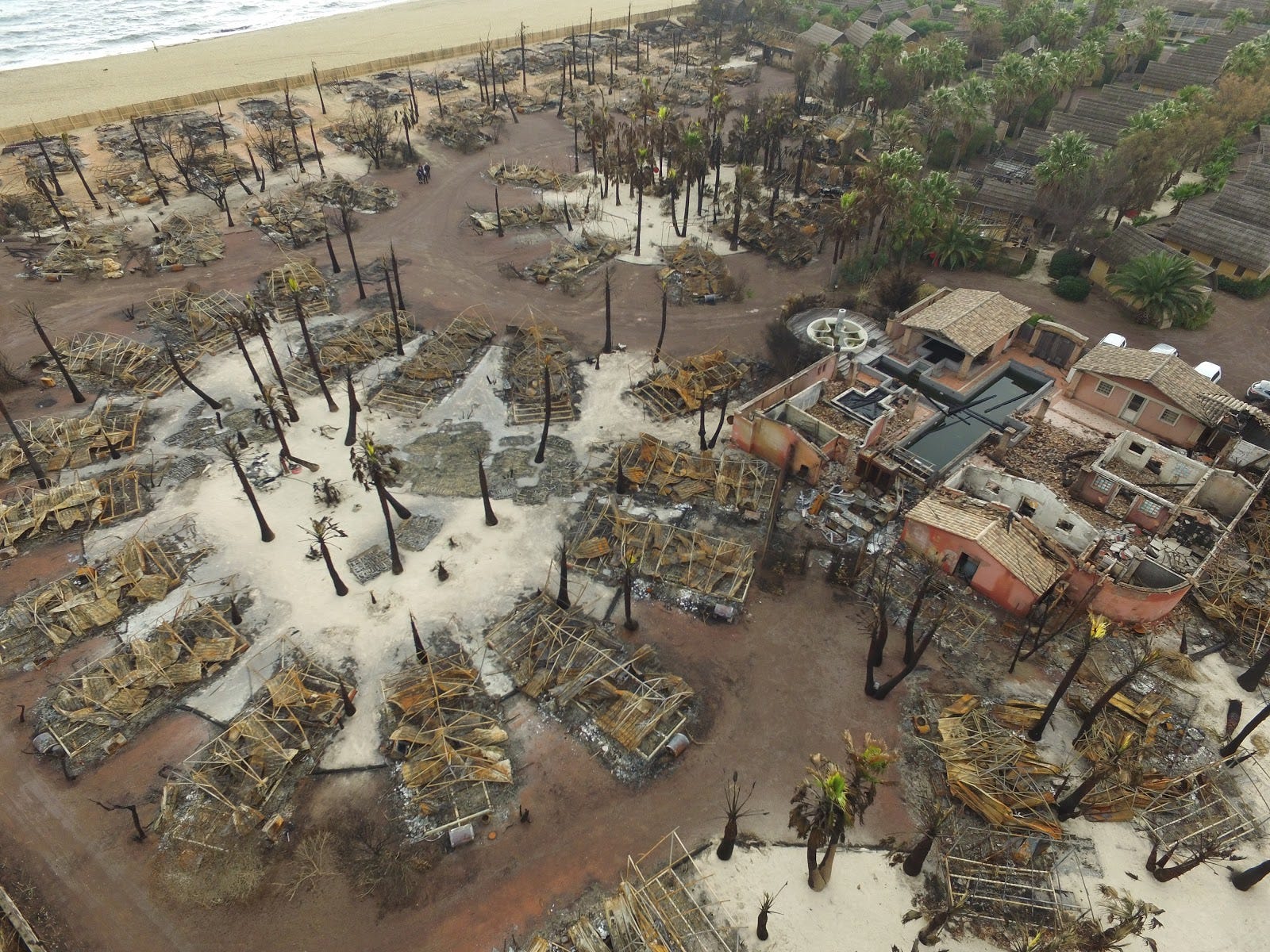
Earlier this year, a major fire broke out at a vacation destination on the coast of France and consumed more than 2 hectares (5 acres), destroying over 80 small housing units with damage valued at over 100 million euros.

Once the flames had subsided, the insurance company came in to assess the damage. The sheer size of the site posed a unique challenge. To make matters worse, many of the roofs damaged by fire were made of thatch and were not strong enough to support an inspector climbing on them to inspect damage. The loss adjuster quickly realized that it would be very difficult to get a clear picture of what had happened from the ground.

Although a plane had already captured some photos after the disaster, the photos were not sharp enough to be of much use. The loss adjuster recommended the insurance company use a drone to help assess the area, so the insurance company hired Dronotec to map the site.
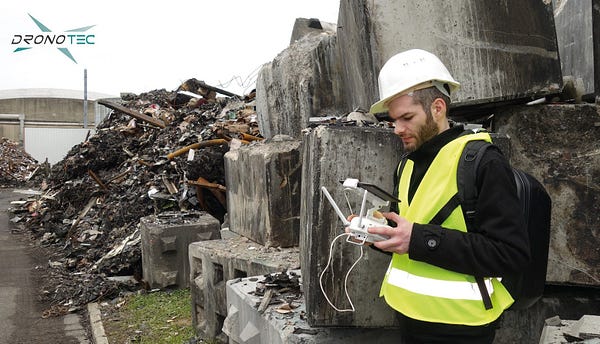
Once on site, the drone pilot flew a DJI Phantom 3 and automated his flight plan using the DroneDeploy app. It only took about 10–12 minutes , flying at 55 meter (180 feet) for the Phantom 3 to collect more than 300 geo-tagged photos covering the area. The drone pilot also supplemented the automated DroneDeploy flight with some oblique imagery taken manually using the DJI GO app.

Dronotec then uploaded all the imagery to DroneDeploy for processing. Three hours later, a 2D map and 3D model were complete and available in the cloud. That’s when the real work began.
Click to explore the interactive orthomosaic map

Collaborating to Determine Responsibility

Since the map was hosted on the DroneDeploy cloud, it could be easily shared via email or by hyperlink and became a central tool where the team could collaborate and share findings.

“My favorite thing about DroneDeploy, is that it’s easy to use and easy to share,” said Emilien. [click to tweet]

Information collected on site by the loss adjuster and insurance inspector, as well as meteorological data about wind direction, was added to the plan as notes, comments and measurements. In addition to counting the number of damaged units (80), the map, combined with DroneDeploy’s suite of analysis tools, allowed them to instantly estimate the volume of debris to be removed.
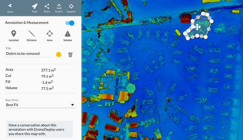
Click to explore the elevation map

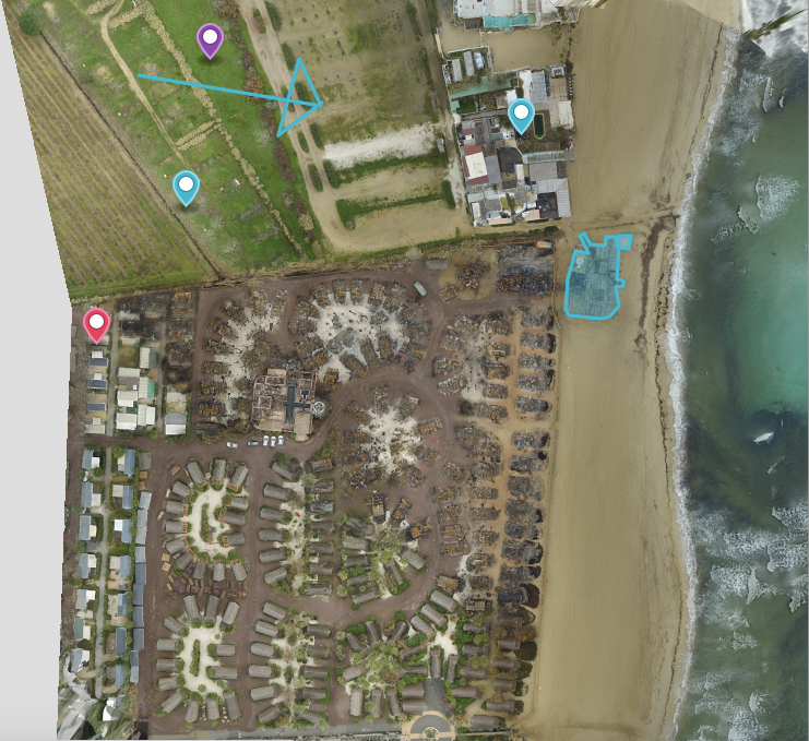
In this case, the main issue at stake was how the fire had spread and who was responsible. As the team began analyzing the map, several theories emerged. The first hypothesis was based on the wind direction on the day of the fire, and posited that the fire had begun at a neighboring field on the north side of the housing after burning of old vegetation for agricultural purposes.
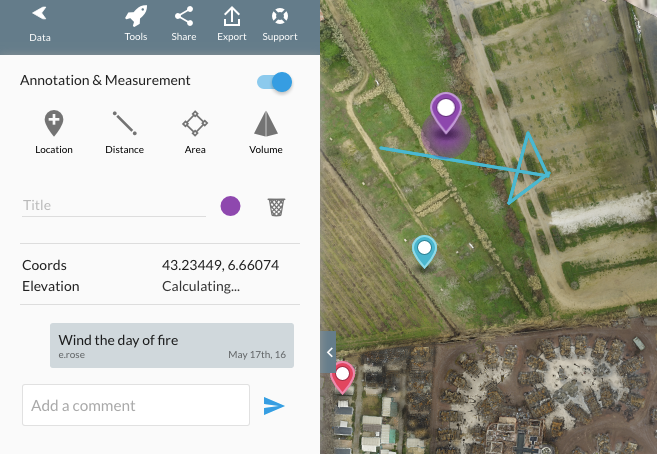
The blue arrow shows wind direction the day of the fire. The blue marker and pink markers show approximate proposed origins for the fire.

The lack of fire damage in the field, however, didn’t support this theory, so the team then considered the wind direction again. Clearly, the fire had spread from northwest (top left) through to the southeast (lower right). After looking closely at the the northwesterly-most point of damage, they identified the first few units to be consumed by the blaze and determined that the fire must have started in or around one of the housing units in this area. Since these units were not on their customer’s property, the insurance company could demonstrate that their customer was not responsible for the fire and thus deny the responsibility claim.

The drone map enabled the insurance company to limit their costs to the 15,000 euro technical investigation and deny the 100,000,000 euro claim. [Click to tweet]

When it comes to a disaster of this scale, the cost of the use of the drone — about .002% of the total claim — is trivial compared to the amount of money saved by demonstrating that the customer was not responsible. More importantly, “there was no other way to gather data”, said Emilien.
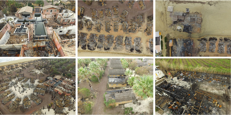
Aerial photos from the scene of the fire.

Insurance for the Insurer

The high degree of accuracy that drone maps provide helps improve the likelihood of identifying the cause of an accident. In some cases, like in the one above at the French vacation site, this helps an insurance company decline a claim if they are not responsible. But what about when their client is responsible? Even in these situations, the speed and efficiency of drone mapping can help to reduce costs and damages for everyone involved.

In many claims, damages related to “business interruption” represent a significant part of the overall damages being sought. Delays in the site inspection or assessment process can even cause conditions on site to get worse, increasing the overall damage. Therefor, the faster that the insurance company can accurately assess a claim, the faster reconstruction can begin, and the more that downtime — and related damages — can be minimized.

The ability to quickly process claims — and even anticipate them — is especially helpful in the case of large scale disasters where many customers are affected and the company is inundated by many claims at once.

Using drones to capture a highly detailed rendering of the site saves time on two fronts. On the one hand, a drone can dramatically reduce the amount of time that a loss adjuster needs to spend on site and reduce risk of accident at dangerous sites. Secondly, the quality of the information captured, and the ability to easily collaborate on a web-based map can help adjusters and insurance inspectors complete their analysis faster.

“The way I see it, DroneDeploy is insurance for the insurer,” said Emilen. [click to tweet]

By reducing the time it takes to assess claims, drone maps can save insurance companies time and help the insuree to get ‘back on track’ faster.

An Ounce of Prevention

Drones are rapidly being adopted for loss assessment in the insurance industry, and Emilien expects that over the next few years, drones will be used to assess claims almost everywhere in the world. But Emilien’s not only interested in using drones to help assess disasters — he also thinks they have a role in helping to prevent them.

Before issuing a new insurance policy, insurance companies can use drones to inspect properties and verify the risks to be covered by the insurance company. Once risks have been identified, the insurance company can then work with their prospect or customer to mitigate risks and help prevent disaster.


Where to Learn More

Explore our support documentation to learn more about how to use some of the tools discussed above, including:

  • Mobile flight app
  • Exporting and sharing data
  • Annotations and measurements
  • Elevation tools
Frank Schroth
Frank Schroth

Frank Schroth is editor in chief of DroneLife, the authoritative source for news and analysis on the drone industry: it’s people, products, trends, and events.
Email Frank
TWITTER:@fschroth


Filed Under: Applications, Business and Finance, Insurance, News Tagged With: DroneDeploy, Insurance

Reader Interactions

Trackbacks

  1. Drone Map Saves Insurance Company €99,985,000 | Drone, UAV, Quadcopter a Multi Rotor News says:
    July 6, 2016 at 10:36 am

    […] post Drone Map Saves Insurance Company €99,985,000 appeared first on […]

    Reply

Leave a Reply Cancel reply

Your email address will not be published. Required fields are marked *

Primary Sidebar

LATEST

Perceptual Robotics Gets £4 Million to Scale Turbine Inspection Drones

Bristol-based drone company adds Innovate UK backing and a fresh check from Investing for Purpose alongside follow-on from Loggerhead Ventures…

Continue Reading Perceptual Robotics Gets £4 Million to Scale Turbine Inspection Drones

Solapur Police Deploy ideaForge Q6 V2 Drones at Pandharpur Wari Pilgrimage

Eight megaphone-equipped ideaForge Q6 V2 drones support crowd monitoring and public address along the 250-kilometer route to Pandharpur, the second…

Continue Reading Solapur Police Deploy ideaForge Q6 V2 Drones at Pandharpur Wari Pilgrimage

Archer Unveils Halo, the Commercial Autonomous VTOL Built With Anduril

Halo is the commercial variant of Archer’s jointly developed dual-use platform, launching with Japan’s Marubeni Aerospace as first strategic partner.…

Continue Reading Archer Unveils Halo, the Commercial Autonomous VTOL Built With Anduril

ABZ Innovation Milestones Point to Company’s Growth

By Dronelife Features Editor Jim Magill ABZ Innovation, a five-year-old Hungarian company that has become a leading manufacturer of spraying…

Continue Reading ABZ Innovation Milestones Point to Company’s Growth

Powerus Expands U.S.-Made Heavy-Lift Drones Into Agriculture

Powerus deals point to growth in U.S., international markets By DRONELIFE Features Editor Jim Magill A Florida-based company that manufactures…

Continue Reading Powerus Expands U.S.-Made Heavy-Lift Drones Into Agriculture

Sila’s $300 Million Raise Targets a Critical Weak Link in the U.S. Drone Supply Chain

Funding will support larger-scale silicon anode manufacturing as demand grows across drones, defense, AI, and electric vehicles Sila has raised…

Continue Reading Sila’s $300 Million Raise Targets a Critical Weak Link in the U.S. Drone Supply Chain

Is the ‘Happy Time’ for Drones Coming to an End? New Government Guide Signals a Shift in Counter-UAS Strategy

Defense publication argues drone threats must become a routine security challenge, not an exceptional one The U.S. Department of War’s…

Continue Reading Is the ‘Happy Time’ for Drones Coming to an End? New Government Guide Signals a Shift in Counter-UAS Strategy

Mind Over Drone: How Cognitive Load and Pilot Fatigue Are Reshaping Flight Safety

Part 1 of DRONELIFE’s Exclusive Series: The Human Edge: People, Perception, and the Future of Drone Operations  In this three-part…

Continue Reading Mind Over Drone: How Cognitive Load and Pilot Fatigue Are Reshaping Flight Safety

As Drone Traffic Grows, Skypuzzler Makes the Case Against AI for Airspace Safety

Danish airspace deconfliction company eyes U.S. market By DRONELIFE Features Editor Jim Magill As the FAA wrestles with the best…

Continue Reading As Drone Traffic Grows, Skypuzzler Makes the Case Against AI for Airspace Safety

FCC Eyes Next Step in Drone Supply Chain Overhaul With Proposed Sales Ban on Military-Grade Foreign Drones

Agency extends trusted drone exemptions while seeking comment on broader commercial restrictions for certain foreign-made systems The Federal Communications Commission…

Continue Reading FCC Eyes Next Step in Drone Supply Chain Overhaul With Proposed Sales Ban on Military-Grade Foreign Drones

Secondary Sidebar

Footer

SPONSORED

Inspired Flight Gremsy IF800 VIO F1 drones geo week

What Will It Take to Strengthen U.S. Drone Manufacturing? A Conversation with Inspired Flight’s CEO

Global Mapper Mobile data collection

Collection Ground Control Points with Global Mapper Mobile

Military Drone Mapping Solutions

How SimActive’s Correlator3D™ is Revolutionizing Military Mapping: An Exclusive Interview with CEO Philippe Simard

Photogrammetry Accuracy Standards

SimActive Photogrammetry Software: Enabling Users to Meet Accuracy Standards for Over 20 Years

NACT Engineering Parrot ANAFI tether indoor shot

Smart Tether for Parrot ANAFI USA from NACT Engineering

Blue Marble, features global mapper, features Blue Marble

Check Out These New Features in Global Mapper v25 from Blue Marble

About Us | Contact Us | Advertise With Us | Write for Us | Privacy Policy | Terms of Service

The Trusted Source for the Business of Drones.

This website uses cookies and third party services. By clicking OK, you are agreeing to our privacy policy. ACCEPT

Manage consent

Privacy Overview

This website uses cookies to improve your experience while you navigate through the website. Out of these, the cookies that are categorized as necessary are stored on your browser as they are essential for the working of basic functionalities of the website. We also use third-party cookies that help us analyze and understand how you use this website. These cookies will be stored in your browser only with your consent. You also have the option to opt-out of these cookies. But opting out of some of these cookies may affect your browsing experience.
Necessary
Always Enabled
Necessary cookies are absolutely essential for the website to function properly. These cookies ensure basic functionalities and security features of the website, anonymously.
CookieDurationDescription
cookielawinfo-checkbox-analytics11 monthsThis cookie is set by GDPR Cookie Consent plugin. The cookie is used to store the user consent for the cookies in the category "Analytics".
cookielawinfo-checkbox-functional11 monthsThe cookie is set by GDPR cookie consent to record the user consent for the cookies in the category "Functional".
cookielawinfo-checkbox-necessary11 monthsThis cookie is set by GDPR Cookie Consent plugin. The cookies is used to store the user consent for the cookies in the category "Necessary".
cookielawinfo-checkbox-others11 monthsThis cookie is set by GDPR Cookie Consent plugin. The cookie is used to store the user consent for the cookies in the category "Other.
cookielawinfo-checkbox-performance11 monthsThis cookie is set by GDPR Cookie Consent plugin. The cookie is used to store the user consent for the cookies in the category "Performance".
viewed_cookie_policy11 monthsThe cookie is set by the GDPR Cookie Consent plugin and is used to store whether or not user has consented to the use of cookies. It does not store any personal data.
Functional
Functional cookies help to perform certain functionalities like sharing the content of the website on social media platforms, collect feedbacks, and other third-party features.
Performance
Performance cookies are used to understand and analyze the key performance indexes of the website which helps in delivering a better user experience for the visitors.
Analytics
Analytical cookies are used to understand how visitors interact with the website. These cookies help provide information on metrics the number of visitors, bounce rate, traffic source, etc.
Advertisement
Advertisement cookies are used to provide visitors with relevant ads and marketing campaigns. These cookies track visitors across websites and collect information to provide customized ads.
Others
Other uncategorized cookies are those that are being analyzed and have not been classified into a category as yet.
SAVE & ACCEPT