from droneanalyst.com
 Last week my colleague Mitch Solomon and I were privileged to be in the company of more than one thousand farmers in rural Decatur, IL, for the two-day Precision Aerial Agriculture Show 2014 (PAAS 2014). Mitch covers five key takeaways from the show in his post about the event – including the most salient one: There is no killer drone app for farmers – rather, drones are a tool with many apps and high ROI. In this post, I’ll give an accounting and analysis of the players in attendance that are supporting the market for drones in agriculture. Some were present, others were mentioned but weren’t present, and still others were surprisingly absent on all counts.
Bottom line
Regardless of which vendors attended or exhibited, here’s what you need to know with regard to the drones vendors serving or intending to serve the agriculture market:
- Most of the companies that serve this market are small businesses. It is clear they are working hard to learn firsthand what farmers want from small drones and in doing so are establishing networks of distributors and service providers that will lock other players out of the market.
- Manufacturers of small drones for precision agriculture are consolidating around DJI and 3DRobotics for their flight control and mission planning software – mainly because of functional maturity and low-cost.
- The large aerospace companies and Department of Defense (DoD) contract vendors do not have a presence in this market. Even though some have participated in agricultural academic studies, as a whole their products are unknown in the farming community. These vendors simply have not established the necessary relationships with growers, dealers, coops, agronomists, and local service providers. As a result, it’s probably too late for them to capture any significant U.S. agriculture market share.
Present and Accounted For
AgEagle – AgEagle had the enviable booth position just inside the show floor, which made it hard to ignore. Its purpose-built Ritewing Zephyr II fixed-wing flyer with uTHERE flight controller and Canon S100 camera goes for about US $12,500. The system comes with a catapult to get it in the air fast, where it will fly at 40 mph and cover approximately 600 acres in 30 minutes. A cloud-based aerial agronomic imagery solution is offered in partnership with MyAgCentral, a division of DN2K. This solution has a fully integrated workflow function that streamlines the process of flying fields and capturing, storing, processing, viewing, and sharing aerial images. For instance, ‘shape files’ can be imported into SMSTM Software for use with variable rate applicators. Information on that partnership can be found here.
Agribotix – Agribotix gets that what is most important in the drone market is data services — not the aircraft. The company deploys a proprietary software solution to deliver geo-referenced aerial images immediately after a flight and high-resolution color and NDVI maps within hours of collection. These images are hosted on Agribotix’s servers for access from multiple devices, including mobile devices so that growers can take them into the field while scouting. Notwithstanding, they do offer the Hornet, which is a simple fixed-wing UAS suitable for agricultural applications. The unique thing here is that you can rent it on a seasonal lease. It uses open-source hardware and software to keep costs low.
Crop Copter / Chief Agronomics – Matt Barnard, a farmer and founder of this drone vendor, understands what growers wants because he listens. Crop Copter offers TBS Discover and his own more durable quad and hexacopter through Van Horn Precision Technologies. They provide the imaging services and support – and even repair – the flyer. All units are complete and ready-to-fly.
Farm Intelligence / FourthWing / WingScan – These Minnesota-based affiliates work in tandem to provide a complete hardware and software solution for precision agriculture. WingScan is the image data and decision support software platform. Fourth Wing is the designer and manufacturer of a small unmanned aircraft system they call Vireo. Vireo comes equipped with a dual-band sensor that is capable of capturing near infrared (NIR) and visual (RGB) data in a single pass. Farm Intelligence sells the device via its FI2 Sales and Leasing.
Field of View LLC – Field of View engineers and sells remote sensing devices for drones that service the agricultural and mapping industries. Their GeoSnap VN-TC is an add-on for the commonly used multispectral cameras. It generates a log of image-associated position and attitude data and manages image capture by triggering the camera based on GPS coordinates. Image log file can be imported into packages like Agisoft to get complete geo-referenced image maps. Look for Field of View products to operate with the open-source MAVLink Micro Air Vehicle Communication Protocol soon.
Horizon Precision Systems – This company’s booth was packed – almost the entire show – and the reason is simple: Horizon offers low-cost entry-level systems. Based in Champaign, Illinois, the company is an offshoot of Horizon Hobby, LLC, which has distribution facilities in the United States, Europe, and China. It has decades of experience developing, distributing, and servicing all types of radio control products. So it is no wonder they created this agriculture-focused subsidiary.
Hoverfly – Hoverfly demonstrated its tethered UAS called “LiveSky.” Tethered UAS, in this case a quadcopter, can stay aloft for much longer than those reliant on a battery alone since power is transmitted from a ground source to the copter via a long tether. This system is interesting because the LiveSky would maintain its position above the control device, allowing you to theoretically place it in a truck bed and drive around with it hovering above the truck. You can view a one-minute video of their demo on YouTube here.
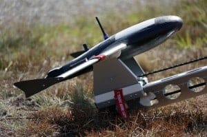
MLB Company – During the show, founder Stephen Morris showcased his company’s $150,000 Super Bat UAV. It’s a high-end drone model that can fly thousands of feet in the air and survey up to 55,000 acres in a single day. When it took to the skies for a demo, all heads turned because it was the only gas-engine-powered drone at the show. All others were electric, and their motors could barely be heard above the sound of wind, but of course they can’t fly nearly as long.
Pix4D – Pix4D is a software package used to convert the hundreds of aerial images that are taken by drones on survey flights into geo-referenced 2D mosaics and 3D surface models and point clouds similar to Autodesk ReCap 360. Their software is bundled by many UAS vendors – including SenseFly, which while on site, handed over the pictures from their demonstration flight earlier in the day. This gave Pix4D the opportunity to show a 3D surface model of a demonstration field. Pretty cool.
PrecisionHawk – PrecisionHawk’s fixed-wing Lancaster platform is impressive. Its lightweight design allows for swappable sensors, and it diagnoses and monitors in flight critical data like battery life, operational weather/wind limitations, structure cracks, and fatigue analysis. But as I have written about here, PrecisionHawk views itself as a data company, not a drone company. As such, it offers a service it calls PrecisionMapper, which is a cloud-based application that gives anyone the ability to upload, store, process, and share their aerial image data.
Precision Drone – Precision Drone LLC is an Indiana company that manufactures multirotor drones built specifically for crop surveillance. The company also offers Precision Vision™, a crop health imaging software package that delivers a composite video overlay showing the true health of a field in color contrast, which lets growers see how much sunlight is being absorbed by the crop canopy.
SenseFly – Of all the demos given at the show, SenseFly’s fixed-wing flight of its eBee Ag drone was truly impressive. The hand-launched and self-landing eBee is constructed of EPP foam and carbon fiber, with detachable wings. It can fly for 45 minutes to a radio-link range of 3 km (1.86 miles), driven by a LiPo battery-powered pusher propeller. eBee Ag can cover up to 1,000 hectares (2,470 acres) in a single flight.
In this small demo, the operator did a great job of explaining flight operations in real-time. For example, he programmed the aircraft to fly a lawn-mower pattern up and down the demo field. But when he commanded, the plane would divert off pattern to photograph an area of interest. When that diversion was complete, the plane would resume the pattern where it left off. Its images are great, too. The vehicle comes with a 12 megapixel Canon S110 NIR (near infrared) still camera as standard with various sensor options, each one electronically integrated in the aircraft’s autopilot.
Trimble – Similar to SenseFly, Trimble’s UX5 fixed wing aerial imaging solution is impressive. Their unit is fully autonomous, flight programmable, and comes with a dedicated Windows-based rugged tablet. It uses a Sony NEX-5 camera outfitted with a Voigtlander lens. This makes for very accurate imaging. But unfortunately they do not offer it for sale in the U.S. yet. Even so, they are working with teams that have regulatory approval for test flights and are perfecting their offering.
Not Present but Accounted For
3Robotics – Agribotix uses (and openly displayed) several 3D Robotics components, including the PixHawk flight controller. Precision Hawk admits it now ships more units with APM 2.6 open source autopilot system, supplanting Lockheed’s proprietary Kestrel autopilot.
DJI – This vendor’s name was mentioned by speakers and users more than any other. I saw more NAZA-M V2 controllers on vendors’ multirotor platforms than any other and the new app for flight planned missions was the topic of many conversations.
MaxMax – Here is where the vendors at the show go to buy an IR-Only, UV + IR + Visible or high resolution (HR) converted camera or send one for conversion.
Tetracam – The smaller and lighter the camera or image sensor, the longer the flight. That’s why Field of View’s multispectral imaging packages are equipped with Tetracam multispectral cameras.
Not Present and Not Accounted For (not a complete list)
Aerial Media Pros
AeroVironment
Aeryon Labs
Altavian
AutoCopter
CropQuest
Draganfly
Delair-Tech
HoneyComb
Lehmann Aviation
Lockheed Martin
MarcusUAV
Yamaha RMAX
It’s not clear why these and many other drone vendors ignore the growing popularity of these types of events. It may be that, like Trimble, they choose to avoid selling their products in the U.S. for fear of being implicated in any wrongdoing by a rogue operator. Or perhaps like PrecisionHawk, they are selling only to researchers who have and FAA certificate of Authorization or Waiver (otherwise known as a COA) as part of their strategy to be a friend of the FAA. Either way, they should have been here if even to get to make introductions and know their target market better.
Wrap-up
To reiterate a point in Mitch’s post amidst the curiosity and excitement at PAAS 2014 was a lot consternation about whether commercial drone operations for agriculture will ever happen. As I have written here, if regulations are too strict, this market will collapse. Some regulations on these types of small drones are due for release to comment by the end of this year. Let’s hope they are not too restrictive and we’ll be at an even bigger show next year.
Colin Snow is CEO and Founder of Drone Analyst– a research and consulting firm supporting all participants in the commercial UAS industry. He loves making, programming, and piloting small drones and got into this business because of his passion for photography, small business, industry research, and vendor analysis.
You can read more of Colin’s excellent insight into the commercial drone industry on his blog droneanalyst.com.
He is always open to field questions and comments so hit him up at colin@droneanalyst.com and follow him on Twitter @droneanalyst
Alan is serial entrepreneur, active angel investor, and a drone enthusiast. He co-founded DRONELIFE.com to address the emerging commercial market for drones and drone technology. Prior to DRONELIFE.com, Alan co-founded Where.com, ThinkingScreen Media, and Nurse.com. Recently, Alan has co-founded Crowditz.com, a leader in Equity Crowdfunding Data, Analytics, and Insights. Alan can be reached at alan(at)dronelife.com


Hi would you mind letting me know which hosting company you’re
working with? I’ve loaded your blog in 3 different browsers aand I must
say this blolg loads a lot faster then most. Can you recommend a good hosting provider at a reasonable price?
Cheers, I appreciate it!