
Correlator3D and Phase One Cameras Support Large-Scale Mapping Operations SimActive Inc.’s Correlator3D software is being used by Air Data Solutions (ADS) to map large oil and gas operations in South Texas. By integrating Phase One camera systems, ADS captures thousands of high-resolution images annually to produce detailed digital maps. Streamlining Aerial Mapping with … [Read more...] about SimActive and Air Data Solutions Enhance Oil & Gas Mapping with High-Resolution Aerial Imagery
orthomosaics
SimActive Enhances Cloud Productivity with Correlator3D Upgrade

Latest SimActive Upgrade of Correlator3D™ Boosts Cloud Capabilities for Enhanced Productivity SimActive Inc., a global leader in photogrammetry software development, has announced significant enhancements to its Correlator3D™ software, aimed at improving productivity in cloud environments. The upgrade allows clients to effortlessly scale their processing in alignment with … [Read more...] about SimActive Enhances Cloud Productivity with Correlator3D Upgrade
Simactive Works to Increase Value in Mining and Surveying Drone Market
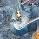
Canadian mapping software company SimActive has added additional capacity to be able to automatically assess multiple volumes of material (aggregates and other material) for projects and to report based upon the findings. If the same area is being flown, users can then compare the volumes and access differences over time. This allows companies to be able to better plan … [Read more...] about Simactive Works to Increase Value in Mining and Surveying Drone Market
Kyrgyz Republic: Terra Drone Subsidiary Launches School Inspections for World Bank

A subsidiary of Japanese drone provider Terra Drone is helping keep schools safe in the Kyrgyz Republic (aka Kyrgyzstan). The World Bank recently commissioned KazUAV to conduct drone inspections over older school buildings across the capital city of Bishek. So far, drones have mapped 12 schools in the nation’s capital and largest city. The pilot project, financed by … [Read more...] about Kyrgyz Republic: Terra Drone Subsidiary Launches School Inspections for World Bank
Wingtra’s New Drone Sets Benchmark in Precision Mapping
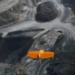
Swiss drone manufacturer Wingtra this week announced the launch of the WingtraOne PPK (Post-Processed Kinematics) model. Working with photogrammetry software provider Pix4D and PPK provider Septentrio, the company says it can now provide orthomosaics mapping and 3D models “with an absolute accuracy down to .4 inches.” Several industry sectors – mining, construction, … [Read more...] about Wingtra’s New Drone Sets Benchmark in Precision Mapping


