
AgEagle Aerial Systems Inc. (also known as EagleNXT) announced today that its multispectral imaging sensors are now compatible with the Inspired Flight Technologies (IFT) IF800 Tomcat and IF1200 UAS drones through IFT's new Smart Dovetail Kit. This integration represents a significant advancement in payload compatibility for professional drone operations. The Smart Dovetail … [Read more...] about EagleNXT Multispectral Sensors Now Compatible with IFT American-Made Drones
multispectral imaging
Optim and Kyuden Drone Service Use AI to Prevent Tree-Fall Disasters
This article published in collaboration with JUIDA, the Japan UAS Industrial Development Association. Japanese technology companies Optim and Kyuden Drone Service (KDS) have developed a new "Dead Tree Detection AI Service" that combines artificial intelligence with drone-mounted multispectral cameras to identify dying trees before they pose safety risks to … [Read more...] about Optim and Kyuden Drone Service Use AI to Prevent Tree-Fall Disasters
AgEagle Launches RedEdge-P Green Camera for Precision Agriculture
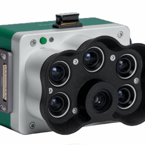
New multispectral sensor offers advanced imaging for farming, research, and environmental management AgEagle Aerial Systems Inc. (NYSE: UAVS) has announced the release of the RedEdge-P™ Green, a new multispectral camera designed to improve precision agriculture and related applications. The company says the sensor will provide farmers, researchers, and environmental managers … [Read more...] about AgEagle Launches RedEdge-P Green Camera for Precision Agriculture
Ascent AeroSystems and AgEagle Partner to Deliver Advanced Agricultural Drone Solution

RedEdge-P camera to be integrated with Spirit UAV, expanding U.S. drone capabilities for precision agriculture At AUVSI XPONENTIAL 2025, Ascent AeroSystems and AgEagle announced a strategic collaboration to integrate the RedEdge-P™ multispectral camera with Ascent’s rugged Spirit™ UAV. This partnership reflects the growing expansion of options in the U.S.-manufactured drone … [Read more...] about Ascent AeroSystems and AgEagle Partner to Deliver Advanced Agricultural Drone Solution
Drone Mapping is Getting Bigger and Better: SimActive’s Philippe Simard Talks Industry Trends

Philippe Simard, of Canada's SimActive mapping software, started out working directly with large mapping companies - or the military. With the growth of the drone industry, however, things have changed. “We used to only work with very highly qualified firms investing millions of dollars in planes – I can still remember the point at which those clients came to us … [Read more...] about Drone Mapping is Getting Bigger and Better: SimActive’s Philippe Simard Talks Industry Trends


