
By Dronelife Features Editor Jim Magill A catastrophic flash flood, which inundated a large swath of the Central Texas Hill Country in the early-morning hours of July 4, 2025, claimed the lives 135 people, a total that officials have said could have been much lower had an early-warning system been in place. Now a Texas-based research and development start-up is … [Read more...] about Drone Docking Stations on Poles Can Respond to Emergencies
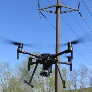
infrastructure inspection
Quantum Solutions Expands SWIR Drone Payload Lineup
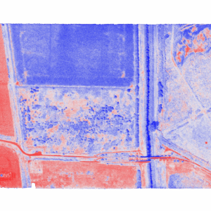
Quantum Solutions, a UK-based imaging technology company, has expanded its lineup of quantum-dot shortwave infrared (SWIR) drone payloads designed to capture data beyond the visible spectrum. The company's Q.Fly family now includes multiple mission-specific configurations—including the Q.Fly Water system for real-time moisture mapping—each built around proprietary quantum-dot … [Read more...] about Quantum Solutions Expands SWIR Drone Payload Lineup
Orkid Unveils All-in-One Drone Combining LiDAR, Photogrammetry, GNSS, and Starlink

Orkid has announced a new variant of its ORKID 260 vertical take-off and landing (VTOL) drone, bringing together four of the most advanced aerial data capture technologies into one integrated, NDAA-compliant system. The ORKID 260VTOL integrated drone combines LiDAR, photogrammetry, GNSS, and Starlink satellite connectivity onboard, allowing all systems to operate … [Read more...] about Orkid Unveils All-in-One Drone Combining LiDAR, Photogrammetry, GNSS, and Starlink
From the Floor of InterGeo 2025: Axpo’s LINIA Software Suite Offers Complete Drone Powerline Inspection Solutions
As grid operators worldwide harness drone technology for the crucial, time-and-labor-intensive process of powerline inspection, Swiss power company Axpo has acquired comprehensive in-house systems and now offers these solutions across Europe and worldwide. Axpo showcased their suite of software services at Intergeo 2025, demonstrating tools designed to streamline powerline … [Read more...] about From the Floor of InterGeo 2025: Axpo’s LINIA Software Suite Offers Complete Drone Powerline Inspection Solutions
Drone America and SpecTIR Partner to Expand Hyperspectral UAS Capabilities
Nevada-Based Companies Collaborate on Advanced Aerial Imaging for Government and Commercial Use A New Collaboration for Enhanced Aerial Sensing Drone America, a U.S. manufacturer of uncrewed aerial systems (UAS), and SpecTIR, a specialist in hyperspectral imaging technologies, have signed a new strategic agreement. The partnership will focus on delivering advanced aerial … [Read more...] about Drone America and SpecTIR Partner to Expand Hyperspectral UAS Capabilities


