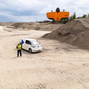
New Study Explores When Drone Mapping Can Reduce Ground Setup A new white paper from Swiss drone manufacturer Wingtra takes on a long-standing question in drone surveying: is it possible to achieve survey-grade accuracy without ground control points (GCPs)? The report, Repeat Accuracy Verification, presents results from 102 drone flights designed to test both accuracy and … [Read more...] about Can You Get Survey-Grade Accuracy Without Ground Control Points?
GNSS
Volatus Integrates Trimble PX-1 RTX for Precision Drone Delivery Operations

Volatus Aerospace Inc. has integrated the Trimble PX-1 RTX solution into its commercial delivery drone service, enabling accurate positioning and heading for fully-remote drone operations beyond visual line of sight (BVLOS). The integration provides clients with turnkey capabilities for highly-accurate aerial data acquisition and real-world mission deployment. The Trimble PX-1 … [Read more...] about Volatus Integrates Trimble PX-1 RTX for Precision Drone Delivery Operations
New GNSS Receiver Platform Boosts Mapping Accuracy and Efficiency: a Case Study

InTerra SmarTarget® streamlines high-precision workflows for commercial drone mappers Accuracy is critical in geospatial work. Drone operators also need systems that save time in the field and in the office. The InTerra SmarTarget® platform aims to deliver both. One commercial drone mapping provider in Nashville, reports major gains after adding the system to its … [Read more...] about New GNSS Receiver Platform Boosts Mapping Accuracy and Efficiency: a Case Study
From the Floor of Intergeo 2025: Trimble Announces Next-Generation Applanix Mobile Mapping Portfolios

Trimble unveiled two comprehensive positioning system portfolios at INTERGEO 2025, designed to meet evolving demands in the geospatial industry. The Applanix POS LVX+ and Applanix POS AVX RTX solutions deliver unparalleled accuracy and efficiency for land-based and airborne mobile mapping applications through next-generation technology. Both portfolios feature an all-in-one … [Read more...] about From the Floor of Intergeo 2025: Trimble Announces Next-Generation Applanix Mobile Mapping Portfolios
PPK for UAV Photogrammetry: the Optimal Workflow to Reduce GCP [Webinar]
Webinar: PPK for UAV Photogrammetry, THE optimal workflow to reduce GCP and maximize ROI – featuring DJI Phantom 4 RTK. Register here to attend this free webinar on July 1st, at 11:00 am EST in the U.S., 17:00 CEST (UTC+2) to join SBG Systems as they announce new features of their flagship INS/GNSS PPK software, Qinertia. This webinar will take viewers through an optimal … [Read more...] about PPK for UAV Photogrammetry: the Optimal Workflow to Reduce GCP [Webinar]


