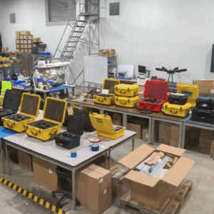
GeoCue, a leading provider of high-accuracy LiDAR mapping hardware and LP360 software, has announced a strategic distribution partnership with JGC Geoinformation System S.A. to bring TrueView LiDAR sensors and LP360 point cloud processing software to Greece, Cyprus, and Balkan countries. Drone LiDAR Mapping Technology for Regional Expansion The partnership positions JGC to … [Read more...] about GeoCue Partners with JGC Geoinformation Systems to Expand LiDAR Mapping Solutions in Greece and Balkans
GeoCue
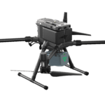
From the Floor Of Intergeo 2025: GeoCue Announces NDAA-Compliant TrueView 641 Aerial LiDAR Sensor

GeoCue unveiled the TrueView 641 at INTERGEO 2025, a new NDAA-compliant aerial LiDAR sensor designed to meet growing demand from surveying and engineering companies across the United States and worldwide. The engineering-grade sensor addresses the increasing number of Federal, State, Local, and Educational contracts requiring NDAA compliance while maintaining cost accessibility … [Read more...] about From the Floor Of Intergeo 2025: GeoCue Announces NDAA-Compliant TrueView 641 Aerial LiDAR Sensor
GeoCue Expands LP360 with Advanced Visualization Tools
New 3D Model Mesh and Gaussian Splatting Add-Ons Unveiled at INTERGEO 2025 GeoCue has introduced two new visualization features for its LP360 software platform at INTERGEO 2025. The company announced the release of the 3D Model Mesh Add-On and the Gaussian Splatting Add-On, designed to improve realism and deliverable quality for users working with the TrueView GO handheld … [Read more...] about GeoCue Expands LP360 with Advanced Visualization Tools
GeoCue Expands TrueView Lineup with TV1 and TV1 Lite: Affordable, High-Performance LiDAR for Drone Surveys

New survey-grade sensors offer precision mapping at accessible price points, bringing professional LiDAR technology to a wider audience. by DRONELIFE Staff Writer Ian J. McNabb Alabama-based LiDAR (Light Detection and Ranging) technology developer GeoCue announced their newest additions to their TrueView lineup of sensors- the TV1 and the TV1 Lite. These new, survey-grade … [Read more...] about GeoCue Expands TrueView Lineup with TV1 and TV1 Lite: Affordable, High-Performance LiDAR for Drone Surveys
GeoCue and CHC Navigation Unveil TrueView 540: LiDAR Innovation
GeoCue and CHC Navigation Unveil TrueView 540 at Geo Week 2024 GeoCue, a leading provider of geospatial hardware and software, and CHC Navigation, a pioneer in precision positioning solutions, have announced the launch of the TrueView 540 at Geo Week 2024. This innovative collaboration introduces a new, efficient, and flexible survey-grade LiDAR system to North America, … [Read more...] about GeoCue and CHC Navigation Unveil TrueView 540: LiDAR Innovation


