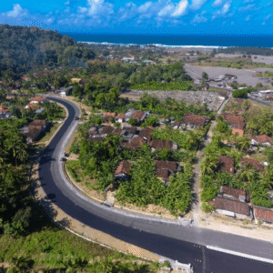
As governments invest in infrastructure to unlock tourism and regional growth, the challenge is no longer just building roads. It is building roads that can endure terrain, climate, and time. A recent case study from Blue Marble Geographics demonstrates how drone-based photogrammetry and watershed modeling are helping engineers design a more resilient transportation corridor … [Read more...] about Designing Resilient Roads on Java’s Southern Coast: A Blue Marble Geographics Case Study
drone photogrammetry
Managing Large Photogrammetry Projects Simultaneously: Can It Be Done?

How scalable workflows, automation, and distributed processing make managing large photogrammetry projects possible. DRONELIFE spoke with Philippe Simard, co-founder and CEO of SimActive, the Canadian company behind the Correlator3D photogrammetry suite, to explore one of the most pressing challenges in the aerial mapping industry: how to efficiently manage and process … [Read more...] about Managing Large Photogrammetry Projects Simultaneously: Can It Be Done?
Headed to INTERGEO 2025? Unmanned Systems Take Center Stage in Frankfurt

Exhibitors, product launches, and presentations highlight drones’ expanding role in mapping, monitoring, and emergency response. The world’s largest geospatial event, INTERGEO 2025, returns to Frankfurt from October 7–9, 2025. This year, drones and unmanned systems are in the spotlight across the exhibition floor and conference stages. From new product launches to in-depth … [Read more...] about Headed to INTERGEO 2025? Unmanned Systems Take Center Stage in Frankfurt
SimActive Enables 3D Calculations from Drone Imagery at Mining Sites

Correlator3D Software Streamlines Volume Measurements and Terrain Analysis SimActive Inc. has announced that its Correlator3D™ software is being used in Germany to generate volumetric calculations from drone imagery. The technology creates dense point clouds at mining sites, enabling accurate volume measurements and detailed terrain analysis. Improving Mining Operations … [Read more...] about SimActive Enables 3D Calculations from Drone Imagery at Mining Sites
DJI Terra 3D Modeling Software Now with 3D Gaussian Splatting – What’s That?

Next-gen reconstruction tech delivers faster, more accurate 3D modeling for large-scale and complex environments DJI Terra: A Powerful Tool for Aerial Data Processing DJI has expanded the capabilities of its Terra 3D modeling software with new reconstruction technologies, including 3D Gaussian Splatting. DJI Terra is designed to create accurate and detailed 2D and 3D models … [Read more...] about DJI Terra 3D Modeling Software Now with 3D Gaussian Splatting – What’s That?


