As defense budgets rise and geopolitical tensions reshape operational priorities, militaries are investing heavily in technologies that can turn raw data into timely, actionable intelligence. For photogrammetry company SimActive, that mission has been central since its founding. In a recent interview with DRONELIFE, CEO Dr. Philippe Simard discussed how the … [Read more...] about Rapid Mapping for a 24/7 Defense Environment: SimActive on Speed, Security, and Scalable Intelligence
drone mapping software
SimActive Software Supports Highway Ramp Expansion Through Integrated Lidar and Photogrammetry

SimActive Inc., a global developer of photogrammetry software, announced that its Correlator3D platform is being used by Settimio Consulting Services to support the engineering design of a major highway ramp expansion. The project leverages the integration of photogrammetry and lidar data to produce precise ground measurements essential for accurate infrastructure … [Read more...] about SimActive Software Supports Highway Ramp Expansion Through Integrated Lidar and Photogrammetry
Photogrammetry vs. LiDAR: Choosing the Right Tool for the Job, with Dr. Philippe Simard

SimActive Inc. has played a pivotal role in the evolution of geospatial data processing since its founding in 2003. Leading the company is Dr. Philippe Simard, a pioneer in the industry with a doctorate in electrical engineering from McGill University, specializing in computer vision. Under Dr. Simard’s leadership, SimActive’s flagship software, Correlator3D™, has become a … [Read more...] about Photogrammetry vs. LiDAR: Choosing the Right Tool for the Job, with Dr. Philippe Simard
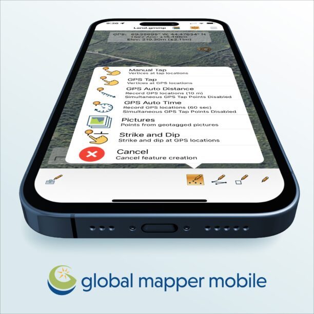
Check Out These New Features in Global Mapper v25 from Blue Marble
Top New Features in Global Mapper v25 Continue reading below, or listen: DroneLife · Blue - Marble - New - Features - Global - Mapper - Pro Blue Marble Geographic’s flagship software, Global Mapper Pro, is an all-in-one GIS package for analyzing and processing vector, terrain, image, and point cloud data. A comprehensive and easy-to-use GIS application that provides an … [Read more...] about Check Out These New Features in Global Mapper v25 from Blue Marble