Used for creating precise 3D models of terrain for mapping and more, LiDAR surveys are an important commercial application for the drone industry - but battery limitations and the associated short flight times remain a problem. Now, California-based Skyfront is working with European UAV LiDAR solution provider Routescene to explore the impact of increasing flight endurance, … [Read more...] about LiDAR Surveys by Drone: Increasing Flight Endurance for a Big Impact on Productivity
drone LiDAR
Visualskies: Meet the UK Studio Living Your Dream Job, Using Drones to Find Lost Cities

By DRONELIFE Staff Writer Jim Magill Using drones, 3D scanning technology, LIDAR and other state-of-the-art technology for measuring, interpreting and visualizing data, a UK-based company has done everything from uncovering lost civilizations to creating augmented reality for movies and television. Founded in 2014, Visualskies has grown from a company narrowly focused on … [Read more...] about Visualskies: Meet the UK Studio Living Your Dream Job, Using Drones to Find Lost Cities
Mapping and LiDAR: SimActive Integrated with LiDAR Solution for Drones

Drone-based mapping and LiDAR are a powerful combination. Now, Canada's SimActive Inc., a leading developer of photogrammetry software that can accommodate aerial imagery from satellite, manned aircraft, or drones, announces the integration of its Correlator3D™ product into LiDAR systems for drones developed by LiDAR USA. LiDARUSA, also known as Fagerman Technologies, is a … [Read more...] about Mapping and LiDAR: SimActive Integrated with LiDAR Solution for Drones
50 Ways to Love Your LiDAR: How LiDAR is Used in Commercial Drone Applications

LiDAR is one of the most important tools in the commercial drone industry. While it has been around since the 1960s when it was mounted to aircraft, its uses have expanded dramatically now that LiDAR can be used with commercial drones. What is LiDAR and how does it work? LiDAR is a remote sensing technology: sensors that are mounted to drones send a pulse from a laser … [Read more...] about 50 Ways to Love Your LiDAR: How LiDAR is Used in Commercial Drone Applications
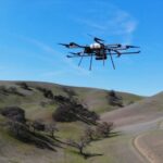
Endurance Flight without a Helicopter: Drone Tech Firm Harris Aerial Demonstrates LiDAR with Carrier H4 Hybrid
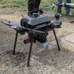
Aerial LiDAR surveys aren't new technology - but now U.S. - based Harris Aerial has demonstrated a new and ground-breaking way of performing them. LiDAR surveys provide critically accurate survey data, allowing for the creation of precise 3D models. LiDAR attached to a helicopter or other manned aircraft have been used for over 50 years in applications like natural hazard … [Read more...] about Endurance Flight without a Helicopter: Drone Tech Firm Harris Aerial Demonstrates LiDAR with Carrier H4 Hybrid


