
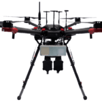
GeoCue unveiled the TrueView 641 at INTERGEO 2025, a new NDAA-compliant aerial LiDAR sensor designed to meet growing demand from surveying and engineering companies across the United States and worldwide. The engineering-grade sensor addresses the increasing number of Federal, State, Local, and Educational contracts requiring NDAA compliance while maintaining cost accessibility … [Read more...] about From the Floor Of Intergeo 2025: GeoCue Announces NDAA-Compliant TrueView 641 Aerial LiDAR Sensor
From the Floor Of Intergeo 2025: GeoCue Announces NDAA-Compliant TrueView 641 Aerial LiDAR Sensor
Ohio Launches Nation’s First Statewide Drone First Responder Program with SkyfireAI

A First for the Nation The State of Ohio has announced a milestone for public safety innovation: the launch of the first statewide Drone First Responder (DFR) program in the United States. The Ohio Department of Transportation (ODOT), through its DriveOhio UAS Center, has selected SkyfireAI to serve as program manager, with CAL Analytics acting as lead technical … [Read more...] about Ohio Launches Nation’s First Statewide Drone First Responder Program with SkyfireAI
Surge in cUAS Procurement Highlights Heightened Focus on Airspace Awareness in Europe, Middle East
As drone-related disruptions mount across Europe, the spotlight on counter-unmanned aircraft systems (cUAS) and airspace awareness technologies has grown more intense. A recent announcement from Fortem Technologies underscores how nations are moving beyond incident response toward preemptive systems deployment to protect critical infrastructure and civil aviation. Fortem’s … [Read more...] about Surge in cUAS Procurement Highlights Heightened Focus on Airspace Awareness in Europe, Middle East
Blue Marble Geographics Unveils Global Mapper® v26.2 at Intergeo 2025

New update delivers user-driven interface improvements, expanded visualization tools, and enhanced file format support. Blue Marble Geographics has announced the release of Global Mapper® v26.2, the latest version of its all-in-one GIS software. The update was introduced this week at Intergeo 2025, the international mapping conference taking place in Frankfurt, Germany this … [Read more...] about Blue Marble Geographics Unveils Global Mapper® v26.2 at Intergeo 2025
From the Floor of Intergeo 2025: Xer Showcases Their Hybrid-Electric X8 Infrastructure Inspection Drone

Swiss manufacturer Xer Technologies presented its Xer X8 hybrid-electric unmanned aircraft system at Intergeo 2025 in Frankfurt, demonstrating the platform's advanced capabilities for large-scale infrastructure monitoring operations. The Xer X8 addresses critical operational limitations of battery-powered drones through innovative hybrid propulsion technology. Xer X8 Technical … [Read more...] about From the Floor of Intergeo 2025: Xer Showcases Their Hybrid-Electric X8 Infrastructure Inspection Drone


