
Appeals Court Upholds Ban on Aerial Mapping by Non-Surveyors A three-judge panel of the 4th U.S. Circuit Court of Appeals has ruled that North Carolina can prohibit the creation of aerial maps by anyone other than licensed land surveyors. This decision affects Michael Jones, a drone operator based in Goldsboro, North Carolina, as well as other entrepreneurs in the state. … [Read more...] about North Carolina Drone Operator to Seek Further Review in First Amendment Lawsuit
Surveying
Pix4D Releases Enhanced PIX4Dcatch 2.0 with AR Features
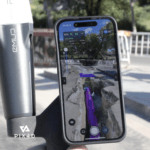
Latest update integrates professional augmented reality tools for improved precision in AEC sectors. Swiss-based Pix4D, a leading provider of drone and terrestrial mapping solutions, announced today the release of the upgraded version of their mobile scanning app, PIX4Dcatch 2.0. This update introduces augmented reality (AR) capabilities and expands compatibility with … [Read more...] about Pix4D Releases Enhanced PIX4Dcatch 2.0 with AR Features
SimActive Photogrammetry Software: Enabling Users to Meet Accuracy Standards for Over 20 Years
Mastering Precision: Navigating the Evolving Landscape of Photogrammetry with SimActive SimActive, a Montreal-based photogrammetry software company with over 20 years serving the mapping community. From satellites to aircraft and drones, one software for all acquisition platforms, designed to support all sizes of professional photogrammetry providers. Accuracy standards are … [Read more...] about SimActive Photogrammetry Software: Enabling Users to Meet Accuracy Standards for Over 20 Years
Event 38 Unmanned Systems Incorporates Advanced LiDAR Technology into E455 Drone
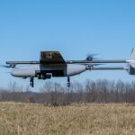
Event 38 Unmanned Systems Integrates Advanced LiDAR onto E455 Drone Event 38 Unmanned Systems, a global leader in the manufacturing of unmanned aerial vehicles, has announced a significant upgrade to their Heavy VTOL E455 Drone. The drone can now be equipped with multiple LiDAR systems, including the Resepi Hesai LIDAR XT-32 developed by Inertial Labs. The integration of … [Read more...] about Event 38 Unmanned Systems Incorporates Advanced LiDAR Technology into E455 Drone
Breaking Barriers: Censys Technologies Soars to New Heights with 30-Mile BVLOS Flight Milestone
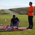
Censys Technologies Achieves 30-Mile BVLOS Flight Milestone with Sentaero 5 Censys Technologies conducted a 30-mile beyond visual line of sight (BVLOS) operation on November 17th, successfully flying the Sentaero 5 over a cellular network in South Florida adjacent to Lake Okeechobee. This milestone was achieved by leveraging a performance-based, non-geo constrained shielded … [Read more...] about Breaking Barriers: Censys Technologies Soars to New Heights with 30-Mile BVLOS Flight Milestone


