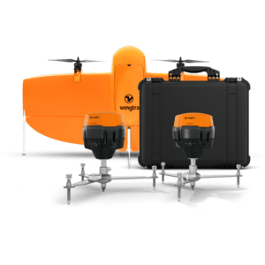
New all-in-one system integrates drone, field setup, and processing to simplify high-accuracy aerial mapping for surveyors of all experience levels. by DRONELIFE Staff Writer Ian J. McNabb Zurich, Switzerland-based drone developers Wingtra recently announced their new WingtraGROUND system, a new ground-control solution designed for the surveying space that combines “drone, … [Read more...] about Wingtra Unveils WingtraGROUND: A Seamless Ground Control Solution for Drone Surveying
Survey
SimActive Photogrammetry Software: Enabling Users to Meet Accuracy Standards for Over 20 Years
Mastering Precision: Navigating the Evolving Landscape of Photogrammetry with SimActive SimActive, a Montreal-based photogrammetry software company with over 20 years serving the mapping community. From satellites to aircraft and drones, one software for all acquisition platforms, designed to support all sizes of professional photogrammetry providers. Accuracy standards are … [Read more...] about SimActive Photogrammetry Software: Enabling Users to Meet Accuracy Standards for Over 20 Years
Skydio, Trimble Partner to Bring Centimeter Level Accuracy to the X10
Skydio and Trimble Collaborate on New Integration for Utilities, Construction and State Transportation Agencies by DRONELIFE Staff Writer Ian J. McNabb Skydio, a California-based drone and UAV manufacturer focused on autonomy, recently announced a new strategic partnership with Trimble to create new integrated workflows designed to unite data capture, data visualization, and … [Read more...] about Skydio, Trimble Partner to Bring Centimeter Level Accuracy to the X10
Virtual Surveyor Releases Newest Version of Smart Drone Surveying Software: Now with Photogrammetry
Virtual Surveyor Releases New Photogrammetry App: Completing Drone Survey Workflow Continue reading below, or listen: DroneLife · Virtual - Surveyor - Adds - Photogrammetry - To - Drone - Surveying - Package by DRONELIFE Staff Writer Ian M. Crosby Software company Virtual Surveyor has updated the newest version of its smart drone surveying software to include drone … [Read more...] about Virtual Surveyor Releases Newest Version of Smart Drone Surveying Software: Now with Photogrammetry
Gremsy Launches Pixy LR: Gimbal for New Sony ILX-LR1 Camera
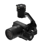
Gremsy, a leading manufacturer of camera gimbal stabilizers for drones, announces the Pixy LR: a purpose-built gimbal for the Sony ILX-LR1. The Sony ILX-LR1 is a major release for the drone industry: a 61 MP full-frame mirrorless camera in a small, lightweight form factor. Sony's SDK enable more features and better performance for aerial surveying and inspection. "Pixy … [Read more...] about Gremsy Launches Pixy LR: Gimbal for New Sony ILX-LR1 Camera


