
As drone incursions at sporting events surge, stadium operators and law enforcement push for Congressional action on counter-UAS measures. By DRONELIFE Features Editor Jim Magill This is the fourth in a series of articles, examining the problems posed to critical infrastructure sites and other significant potential targets of drone incursions by hostile actors. Previous … [Read more...] about Super Bowl Security: The Growing Challenge of Unauthorized Drones Over Stadiums
Drone News Feeds
Advexure and MatrixSpace Partner to Enhance Drone Operations and Security

Collaboration Expands Capabilities for Public Safety, Infrastructure, and Utilitie Advexure, a U.S.-based provider of drone systems and technology solutions, has announced a partnership with MatrixSpace, a company specializing in AI-enhanced radar sensing. This collaboration aims to improve drone operations and perimeter security for public safety, infrastructure, and utility … [Read more...] about Advexure and MatrixSpace Partner to Enhance Drone Operations and Security
DIC Corporation’s HAGAMOSphere™ Wins CES Innovation Award for Cutting-Edge Multicopter Design
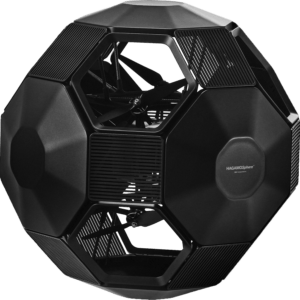
With a unique omnidirectional propulsion system and AI-driven flight capabilities, the HAGAMOSphere™ sets new standards for maneuverability and precision in drone technology. by DRONELIFE Staff Writer Ian J. McNabb This article published in collaboration with JUIDA, the Japan UAS Industrial Development Association. Japanese technology firm DIC Corporation recently … [Read more...] about DIC Corporation’s HAGAMOSphere™ Wins CES Innovation Award for Cutting-Edge Multicopter Design
Meteomatics Introduces High-Resolution Weather Model for U.S. Market
New 1km Weather Model Provides Hyper-Local Forecasting for Businesses Companies in energy, insurance, aviation, and agriculture can now track weather events at a street-level resolution with Meteomatics' new U.S. weather model. The model, which covers the contiguous U.S. at a resolution of 1 kilometer, offers nine times the detail of current leading weather solutions that … [Read more...] about Meteomatics Introduces High-Resolution Weather Model for U.S. Market
GeoCue and Clogworks Technologies Announce Partnership to Expand LiDAR Drone Mapping Solutions
New Collaboration Enhances Aerial Surveying Capabilities with Integrated LiDAR and Software Solutions GeoCue has announced a new partnership with UK-based drone manufacturer Clogworks Technologies Limited. This collaboration integrates GeoCue’s TrueView LiDAR and LP360 software with Clogworks’ Dark Matter series of UAVs. The partnership aims to provide surveyors and mapping … [Read more...] about GeoCue and Clogworks Technologies Announce Partnership to Expand LiDAR Drone Mapping Solutions


