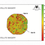
The Commercial Drone Fund, a venture capital fund launched by Airware focused on investing in promising commercial drone businesses around the world, announced it has invested in Raptor Maps, a Cambridge-based company developing a drone-enabled technology platform for the agriculture sector. Integrating drones, tractor-mounted sensors and software, Raptor Maps has developed … [Read more...] about Commercial Drone Fund Invests in Raptor Maps, a Drone-Enabled Platform for Agriculture Yield Management
Agriculture
Can AeroVironment Compete in the Commercial Drone Market?

AeroVironment’s new drone and cloud-based analytics platform squarely targets the commercial sector, but are they targeting the wrong vertical, too late in the game? QuickTake THE FACTS: Earlier this month, the military and tactical unmanned aircraft systems manufacturer AeroVironment (NASDAQ:AVAV) proudly unveiled its new QuantixTM drone and a cloud-based analytics … [Read more...] about Can AeroVironment Compete in the Commercial Drone Market?
AeroVironment Unveils Quantix, an Industrial Strength Drone for Commercial Markets
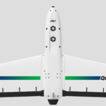
At Drone World Expo Aerovironment unveiled the Qunatix, an industrial strength fixed wing drone for the commercial market. The Quantix is a key piece to a larger end to end solution AeroVironment has developed to meet the needs of the agriculture, energy, and transportation industries, among others. The solution which includes the drone and a complete cloud based analytics … [Read more...] about AeroVironment Unveils Quantix, an Industrial Strength Drone for Commercial Markets
Aeromapper Drone Helps Map Wildfire Damage

With the devastating scourge of wildfires that have plagued western states, coupled with the recent outbreaks in the southern Appalachian region, government officials are turning to drones again to assess damage and plan for more efficient recovery. This past week, Canadian drone company Aeromao announced that the USDA Ungulate Disease and Damage research project will use … [Read more...] about Aeromapper Drone Helps Map Wildfire Damage
DJI Raises Ante in Industrial Space with Addition of Zoom Camera, Zenmuse Z30
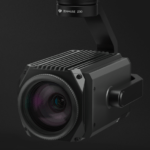
DJI has announced the Zenmuse Z30, an aerial zoom camera that can be easily snapped into DJI's Matrice airframes. The high end imaging capability that the Z30 brings to the table will have applicability to a number of commercial markets including traffic, construction, inspections, and disaster relief such as search and rescue and damage assessment. Designed to seamlessly … [Read more...] about DJI Raises Ante in Industrial Space with Addition of Zoom Camera, Zenmuse Z30


