• Skip to main content
  • Skip to secondary menu
  • Skip to primary sidebar
  • Skip to secondary sidebar
  • Skip to footer
  • DroneRacingLife
  • DroneFlyers
  • Newsletter
DroneLife

DRONELIFE

Stay up to date on all the latest Drone News

  • News
  • Products
  • Industries
    • Agriculture
    • Construction
    • Delivery
    • Dual Use
    • Inspection
    • Public Safety
    • Surveying
  • Enthusiasts
  • Regulations
  • Business
  • Video
  • Podcasts

Drones to Manage Powerline Vegetation: Routescene UAV LiDAR

October 10, 2021 by Miriam McNabb 6 Comments

Routescene drones for managing powerline vegetationRoutescene case study demonstrates the benefits of using drones to manage powerline vegetation.

by DRONELIFE Staff Writer Ian M. Crosby

The latest in a series of forestry based case studies conducted by Routescene showcases the value of remote sensing techniques like UAV LiDAR for identifying diseased or damaged trees and overgrown vegetation close to powerlines to prevent outages or forest fires.

The project at Pound Farm in Suffolk, UK sought to identify ailing trees and overgrown vegetation that posed a risk of damaging the 33kV power lines running through the 120 acre forest. Routescene collaborated with 2Excel Geo, Fera Science and Dielmo 3D in order to provide the results to the Woodland Trust that owns the land.

In recent years, the forest has been affected by the highly destructive fungal disease known as Ash dieback. Capable of killing ash trees quickly, its symptoms include a blackening and wilting of leaves in mid to late summer.

LiDAR, RGB, Multispectral and Hyperspectral imaging techniques were each employed to determine their ability to identify signs of Ash dieback.

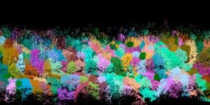
The vegetation penetration capabilities of the Routescene LiDAR system allowed for the compilation of a profile of individual trees from ground level to the canopy to examine health. Density analysis of the LiDAR data gathered from the crown of the trees was to be used to identify disease. LiDAR was also able to easily capture the thin powerlines to establish the proximity of surrounding vegetation.

In-depth processing of the LiDAR data was conducted with Routescene’s LidarViewer post- processing software . The team created a Digital Terrain Model (DTM) to locate power lines and pylons and a Digital Surface Model (DSM) to ascertain the height of the trees. This was used to calculate the normalized height and help identify individual trees.

“The high density point cloud from the Routescene UAV LiDAR system facilitated the improved detection of individual trees within the woodland,” stated Dr. Chloe Barnes of 2Excel Geo. “The structural information provided by the LiDAR also provided complimentary datasets to the spectral information from the airborne imagery for tree health and species classification.”

The addition of RGB imagery made it easy to view the colour of the leaves to determine tree health. Merging RGB imagery with LiDAR data gave each LiDAR point an RGB value, to colourise the point cloud, providing true colour to the LiDAR images that render them easier to interpret.

Hyperspectral and Multispectral imaging data was gathered by light aircraft and drones. Used to capture data beyond the range of human vision, when statistically analyzed this data can help to identify the species, health and stress of the trees. 18 vegetation indexes were used to check tree health, including the Normalised Difference Vegetation Index (NDVI), which is a function of red and near-infrared energy that can indicate leaf area index, plant biomass and growth vigor.

The LiDAR point cloud was combined with the Multispectral and Hyperspectral imagery using a series of machine learning approaches. The various vegetation indices, color and point cloud densities were analyzed to look for evidence of disease, such as individual trees without leaves, with different leaf colors, different vegetation index results or lower point cloud density values in the top layer of the canopy. Density analysis of the LiDAR data and Hyperspectral data was then carried out, using data from the top 2 meters of the tree crown, to identify disease.

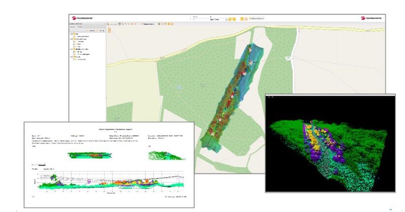
Lastly, the team needed to provide outputs which could be interpreted easily by the Woodland Trust. LiDAR data was exported to Dielmo 3D’s web based portal for visualization and reporting. These results were used to locate areas at risk along the powerline. The analysis focused on trees in close proximity to the powerline to create an overgrown vegetation and Ash dieback risk map.

“This project showcased how useful and practical the outputs created from UAV LiDAR data can be to recognize areas of disease within a woodland,” said Gert Riemersma, CTO and founder of Routescene. “It also demonstrated perfectly how high resolution UAV LIDAR surveys can be used to identify individual power lines and determine which trees and vegetation may cause damage either as a result of growth or disease.”

See more about drones in forestry here, or more about drone-based LiDAR here.

Ian attended Dominican University of California, where he received a BA in English in 2019. With a lifelong passion for writing and storytelling and a keen interest in technology, he is now contributing to DroneLife as a staff writer


Miriam McNabb

Miriam McNabb is the Editor-in-Chief of DRONELIFE and CEO of JobForDrones, a professional drone services marketplace, and a fascinated observer of the emerging drone industry and the regulatory environment for drones. Miriam has penned over 3,000 articles focused on the commercial drone space and is an international speaker and recognized figure in the industry.  Miriam has a degree from the University of Chicago and over 20 years of experience in high tech sales and marketing for new technologies.
For drone industry consulting or writing, Email Miriam.

TWITTER:@spaldingbarker

Subscribe to DroneLife here.

Filed Under: Drone News Feeds, News Tagged With: drone based LiDAR, LiDAR UAV, managing powerline vegetation, Routescene

Reader Interactions

Trackbacks

  1. Drones to Manage Powerline Vegetation: Routescene UAV LiDAR | taktik(z) GDI (Government Defense Infrastructure) says:
    October 12, 2021 at 12:28 am

    […] DroneLife source|articles […]

    Reply
  2. Drones to Manage Powerline Vegetation: Routescene UAV LiDAR | Remote Control Vehicle World says:
    October 11, 2021 at 11:04 am

    […] post Drones to Manage Powerline Vegetation: Routescene UAV LiDAR appeared first on […]

    Reply
  3. Drones to Manage Powerline Vegetation: Routescene UAV LiDAR - DronesOnline.site says:
    October 11, 2021 at 1:20 am

    […] post Drones to Manage Powerline Vegetation: Routescene UAV LiDAR appeared first on […]

    Reply
  4. Drones to Manage Powerline Vegetation – Dronestagram Blog says:
    October 10, 2021 at 7:44 pm

    […] More… […]

    Reply
  5. Drones to Manage Powerline Vegetation – Game Up News says:
    October 10, 2021 at 6:37 pm

    […] Source link […]

    Reply
  6. Drones to Manage Powerline Vegetation: Routescene UAV LiDAR | Drone Films Limited says:
    October 10, 2021 at 6:16 pm

    […] post Drones to Manage Powerline Vegetation: Routescene UAV LiDAR appeared first on […]

    Reply

Leave a Reply Cancel reply

Your email address will not be published. Required fields are marked *

Primary Sidebar

LATEST

Teledyne FLIR OEM Upgrades Prism SKR Software for Autonomous Target Recognition

New release combines mission execution and intelligent supervision in a single autonomy platform Teledyne FLIR OEM has announced an upgrade…

Continue Reading Teledyne FLIR OEM Upgrades Prism SKR Software for Autonomous Target Recognition

Drone Operations Software Company AirHub Closes €4.4M Series A

AirHub, a European drone operations software company based in The Hague, has closed a €4.4 million Series A funding round.…

Continue Reading Drone Operations Software Company AirHub Closes €4.4M Series A

Arrive AI Patents Shared Drone Delivery Endpoint With Tenth U.S. Patent

Arrive AI (NASDAQ: ARAI) has secured its tenth U.S. patent, strengthening its intellectual property portfolio for autonomous drone delivery infrastructure.…

Continue Reading Arrive AI Patents Shared Drone Delivery Endpoint With Tenth U.S. Patent

Korean eVTOL Developer Airbility Partners on UAV Public Safety in Thailand

South Korean eVTOL developer Airbility has signed a four-party Memorandum of Understanding to deploy UAV systems for public safety and…

Continue Reading Korean eVTOL Developer Airbility Partners on UAV Public Safety in Thailand

Is U.S. Manufacturing the Answer? SKYROVER Signals a New Strategy as FCC Pressure Mounts

A Hong Kong-based drone company outlines a five-year U.S. roadmap, raising questions about compliance, supply chains, and market access A…

Continue Reading Is U.S. Manufacturing the Answer? SKYROVER Signals a New Strategy as FCC Pressure Mounts

Blue Marble Geographics and Avenza Systems Combine to Create Unified Geospatial Platform

Merger connects office-based analysis with field operations for end-to-end spatial workflows Blue Marble Geographics and Avenza Systems, Inc. have announced…

Continue Reading Blue Marble Geographics and Avenza Systems Combine to Create Unified Geospatial Platform

Amazon Prime Air Adjusts Course After Richardson Setbacks

After rocky start in Texas city, Amazon Air service flying high By DRONELIFE Features Editor Jim Magill After only a…

Continue Reading Amazon Prime Air Adjusts Course After Richardson Setbacks

Airspace Security at 2026 JUNO Awards

RF-Cyber counter-drone system enables non-disruptive protection for large public event D-Fend Solutions announced that its EnforceAir counter-drone system was deployed…

Continue Reading Airspace Security at 2026 JUNO Awards

Will States Be Ready with Counter Drone Tech for the FIFA World Cup?

Funding snafu, other issues delay counter-UAS ramp-up in Maryland, elsewhere By DRONELIFE Features Editor Jim Magill (Editor’s note: This is…

Continue Reading Will States Be Ready with Counter Drone Tech for the FIFA World Cup?

Strait of Hormuz Tensions Highlight a Growing Role for Small Drone Surveillance

Maritime risk, insurance pressure, and degraded navigation signals point to new use cases for commercial UAV systems Ongoing tension in…

Continue Reading Strait of Hormuz Tensions Highlight a Growing Role for Small Drone Surveillance

Secondary Sidebar

Footer

SPONSORED

Inspired Flight Gremsy IF800 VIO F1 drones geo week

What Will It Take to Strengthen U.S. Drone Manufacturing? A Conversation with Inspired Flight’s CEO

Global Mapper Mobile data collection

Collection Ground Control Points with Global Mapper Mobile

Military Drone Mapping Solutions

How SimActive’s Correlator3D™ is Revolutionizing Military Mapping: An Exclusive Interview with CEO Philippe Simard

Photogrammetry Accuracy Standards

SimActive Photogrammetry Software: Enabling Users to Meet Accuracy Standards for Over 20 Years

NACT Engineering Parrot ANAFI tether indoor shot

Smart Tether for Parrot ANAFI USA from NACT Engineering

Blue Marble, features global mapper, features Blue Marble

Check Out These New Features in Global Mapper v25 from Blue Marble

About Us | Contact Us | Advertise With Us | Write for Us | Privacy Policy | Terms of Service

The Trusted Source for the Business of Drones.

This website uses cookies and third party services. By clicking OK, you are agreeing to our privacy policy. ACCEPT

Manage consent

Privacy Overview

This website uses cookies to improve your experience while you navigate through the website. Out of these, the cookies that are categorized as necessary are stored on your browser as they are essential for the working of basic functionalities of the website. We also use third-party cookies that help us analyze and understand how you use this website. These cookies will be stored in your browser only with your consent. You also have the option to opt-out of these cookies. But opting out of some of these cookies may affect your browsing experience.
Necessary
Always Enabled
Necessary cookies are absolutely essential for the website to function properly. These cookies ensure basic functionalities and security features of the website, anonymously.
CookieDurationDescription
cookielawinfo-checkbox-analytics11 monthsThis cookie is set by GDPR Cookie Consent plugin. The cookie is used to store the user consent for the cookies in the category "Analytics".
cookielawinfo-checkbox-functional11 monthsThe cookie is set by GDPR cookie consent to record the user consent for the cookies in the category "Functional".
cookielawinfo-checkbox-necessary11 monthsThis cookie is set by GDPR Cookie Consent plugin. The cookies is used to store the user consent for the cookies in the category "Necessary".
cookielawinfo-checkbox-others11 monthsThis cookie is set by GDPR Cookie Consent plugin. The cookie is used to store the user consent for the cookies in the category "Other.
cookielawinfo-checkbox-performance11 monthsThis cookie is set by GDPR Cookie Consent plugin. The cookie is used to store the user consent for the cookies in the category "Performance".
viewed_cookie_policy11 monthsThe cookie is set by the GDPR Cookie Consent plugin and is used to store whether or not user has consented to the use of cookies. It does not store any personal data.
Functional
Functional cookies help to perform certain functionalities like sharing the content of the website on social media platforms, collect feedbacks, and other third-party features.
Performance
Performance cookies are used to understand and analyze the key performance indexes of the website which helps in delivering a better user experience for the visitors.
Analytics
Analytical cookies are used to understand how visitors interact with the website. These cookies help provide information on metrics the number of visitors, bounce rate, traffic source, etc.
Advertisement
Advertisement cookies are used to provide visitors with relevant ads and marketing campaigns. These cookies track visitors across websites and collect information to provide customized ads.
Others
Other uncategorized cookies are those that are being analyzed and have not been classified into a category as yet.
SAVE & ACCEPT