
• Skip to main content
  • Skip to secondary menu
  • Skip to primary sidebar
  • Skip to secondary sidebar
  • Skip to footer
  • DroneRacingLife
  • DroneFlyers
  • Newsletter
DroneLife

DRONELIFE

Stay up to date on all the latest Drone News

  • News
  • Products
  • Industries
    • Agriculture
    • Construction
    • Delivery
    • Dual Use
    • Inspection
    • Public Safety
    • Surveying
  • Enthusiasts
  • Regulations
  • Business
  • Video
  • Podcasts

Drones Take Science to New Heights: UAF Research at AGU24

December 1, 2024 by Miriam McNabb Leave a Comment

Exploring Snow, Sea Ice, and Remote Education with UAV Technology

Scientists from the University of Alaska Fairbanks (UAF) Geophysical Institute are leveraging drone technology to push the boundaries of research in challenging environments. At the 2024 American Geophysical Union (AGU) Fall Meeting, UAF researchers will present innovative projects showcasing drones’ capabilities in measuring snow and sea ice, surveying the sea floor, and educating remote communities in Alaska.

Drones in Polar Research
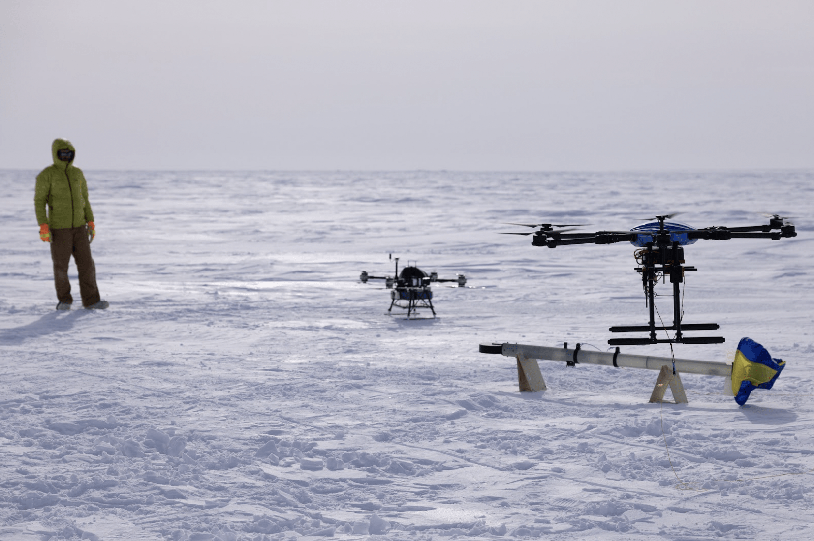
The Long-range Airborne Snow and Sea Ice Thickness Observing System being tested on Alaska’s Arctic coast. UAF photo by Bryan Whitten

Measuring Snow and Sea Ice Depth by UAV

The Long-range Airborne Snow and Sea Ice Thickness Observing System (LASSITOS) is tackling the challenges of polar research. Led by postdoctoral fellow Achille Capelli, the project aims to improve measurements of snow cover and sea ice thickness, crucial for understanding polar changes and supporting activities like marine navigation and ice road transportation.

“Unmanned aerial vehicles can fly over ice inaccessible to surface travel, allow flexible deployment from land and marine platforms, and cause less disturbance than manned aircrafts,” Capelli explains. This innovative sensor system is set to provide accurate data while addressing the complexities of working in remote polar regions.

Capelli will present the LASSITOS project during the AGU meeting’s poster session on Monday, Dec. 9, from 1:40 to 5:30 p.m.

For more information about UAF’s polar research, visit the Geophysical Institute’s website.

Drone’s Eye View of the Sea Floor

Assistant professor Michael Roddewig is revolutionizing coastal mapping with a drone-borne maritime lidar system. Unlike traditional maritime lidars, which require costly and manned aircraft, this new technology operates on a fixed-wing unmanned aerial vehicle managed by UAF’s Alaska Center for Unmanned Aerial System Integration.

“Alaska’s remoteness, inclement weather, and limited personnel capacity provide unique challenges to data gathering with traditional maritime lidar,” Roddewig notes. The UAV-based lidar offers a cost-effective and adaptable solution for mapping coastal bathymetry, surveying fish populations, and studying plankton.

Roddewig will share insights on this project during the AGU meeting on Tuesday, Dec. 10, from 1:40 to 5:30 p.m.

Learn more about UAF’s advances in lidar technology in the abstract, here.

Inspiring Remote Alaska Students with Drone Technology

Helena Buurman of the Alaska Satellite Facility will present the “Drones on Ice!” program, which introduces K-12 students in remote Alaska communities to drone technology. Funded by NASA, this program combines academic concepts with traditional and Indigenous knowledge, offering students hands-on learning and opportunities to address local challenges like identifying open water on frozen rivers.

“Taught as a three-day workshop in Alaska’s remote villages, the program activities tie academic concepts into traditional and Indigenous knowledge and education systems to create a relevant and impactful learning experience for students,” Buurman explains.

Communities such as Venetie, Shageluk, and Utqiaġvik have welcomed the program, which plans to expand into geospatial technologies. Buurman will share details during the AGU meeting on Tuesday, Dec. 10, from 1:40 to 5:30 p.m.

For more details on the program, see the abstract here.

Want DRONELIFE news delivered to your inbox every weekday?  Sign up here.

Read more:

  • Drone Cargo Delivery: University of Alaska to Build New Hangar for Base of Operations
  • A 45 Mile, Airport-to-Airport Drone Delivery in Alaska
  • Launching Alaska’ First Large Drone Operation from an International Airport: University of Alaska
Miriam McNabb

Miriam McNabb is the Editor-in-Chief of DRONELIFE and CEO of JobForDrones, a professional drone services marketplace, and a fascinated observer of the emerging drone industry and the regulatory environment for drones. Miriam has penned over 3,000 articles focused on the commercial drone space and is an international speaker and recognized figure in the industry.  Miriam has a degree from the University of Chicago and over 20 years of experience in high tech sales and marketing for new technologies.
For drone industry consulting or writing, Email Miriam.

TWITTER:@spaldingbarker

Subscribe to DroneLife here.
Filed Under: Drone News, Drone News Feeds, Drones in the News, Featured, News Tagged With: Alaska Geophysical Institute, coastal mapping, Drone Education, drones, K-12 STEM, maritime lidar, polar research, remote learning, sea ice measurement, UAV technology

Reader Interactions

Leave a Reply Cancel reply

Your email address will not be published. Required fields are marked *

Primary Sidebar

LATEST

Can Commercial Drones Survive Electronic Warfare? U.S. Army Expands Testing Opportunities

New Army testing events give drone manufacturers access to realistic GPS jamming and communications interference, with three sessions scheduled for…

Continue Reading Can Commercial Drones Survive Electronic Warfare? U.S. Army Expands Testing Opportunities

Satellite Connectivity for Drones Moves Closer to Commercial Scale

New agreement advances the commercial infrastructure needed to deliver and manage satellite communications for drones and advanced air mobility Galaxy…

Continue Reading Satellite Connectivity for Drones Moves Closer to Commercial Scale

ETH Zurich Develops Flexible Drone That Can Survive Collisions

New FlexiQuad design could improve drone operations in confined spaces, search and rescue missions, and challenging environments. Researchers at ETH…

Continue Reading ETH Zurich Develops Flexible Drone That Can Survive Collisions

SimActive and Phase One Streamline Large-Scale Defense Mapping

Integration helps defense organizations process thousands of high-resolution aerial images faster, reducing manual work and speeding up map production. SimActive…

Continue Reading SimActive and Phase One Streamline Large-Scale Defense Mapping

Alpha Unmanned Systems Closes €4 Million Financing Round

The Madrid company, which builds unmanned tactical helicopters, will use the funds for a new production plant, more staff and…

Continue Reading Alpha Unmanned Systems Closes €4 Million Financing Round

Purdue’s Windracers ULTRA First Flyer in Indiana Drone Corridor

The heavy-lift aircraft flew more than 50 miles during the corridor’s opening event at Terre Haute. Purdue will make it…

Continue Reading Purdue’s Windracers ULTRA First Flyer in Indiana Drone Corridor

Is Trump’s Plan to Build a U.S. Drone Industry Working?

Foreign manufacturers are pursuing U.S. production, domestic companies are attracting investment, and Pentagon orders are growing. But can the industry…

Continue Reading Is Trump’s Plan to Build a U.S. Drone Industry Working?

Drone Activity Disrupts Jersey Airport for Two Consecutive Nights

Police are appealing for witnesses after multiple drones entered restricted airspace on October 30 and 31. The Government of Jersey…

Continue Reading Drone Activity Disrupts Jersey Airport for Two Consecutive Nights

Navy DRPM RAS Seeks Cargo Drones for Marine Corps

The new robotic and autonomous systems portfolio office will host a cargo drone demonstration in Huntsville in early 2027. Strong…

Continue Reading Navy DRPM RAS Seeks Cargo Drones for Marine Corps

Blue Marble Geographics Introduces New Global Mapper Subscription for GIS and Drone Mapping

Three subscription tiers bring mapping, terrain analysis, lidar processing, and photogrammetry tools into a unified offering. Blue Marble Geographics has…

Continue Reading Blue Marble Geographics Introduces New Global Mapper Subscription for GIS and Drone Mapping

Secondary Sidebar

Footer

SPONSORED

drone cleaning

Do Cleaning Drones Actually Work? 15 Apellix Before-and-After Jobs Show the Results

What Is the Best Commercial Cleaning Drone in 2026? Specs, Prices, and a Head-to-Head Comparison

Inspired Flight Gremsy IF800 VIO F1 drones geo week

What Will It Take to Strengthen U.S. Drone Manufacturing? A Conversation with Inspired Flight’s CEO

Global Mapper Mobile data collection

Collection Ground Control Points with Global Mapper Mobile

Military Drone Mapping Solutions

How SimActive’s Correlator3D™ is Revolutionizing Military Mapping: An Exclusive Interview with CEO Philippe Simard

Photogrammetry Accuracy Standards

SimActive Photogrammetry Software: Enabling Users to Meet Accuracy Standards for Over 20 Years

About Us | Contact Us | Advertise With Us | Write for Us | Privacy Policy | Terms of Service

The Trusted Source for the Business of Drones.

This website uses cookies and third party services. By clicking OK, you are agreeing to our privacy policy. ACCEPT

Manage consent

Privacy Overview

This website uses cookies to improve your experience while you navigate through the website. Out of these, the cookies that are categorized as necessary are stored on your browser as they are essential for the working of basic functionalities of the website. We also use third-party cookies that help us analyze and understand how you use this website. These cookies will be stored in your browser only with your consent. You also have the option to opt-out of these cookies. But opting out of some of these cookies may affect your browsing experience.
Necessary
Always Enabled
Necessary cookies are absolutely essential for the website to function properly. These cookies ensure basic functionalities and security features of the website, anonymously.
CookieDurationDescription
cookielawinfo-checkbox-analytics11 monthsThis cookie is set by GDPR Cookie Consent plugin. The cookie is used to store the user consent for the cookies in the category "Analytics".
cookielawinfo-checkbox-functional11 monthsThe cookie is set by GDPR cookie consent to record the user consent for the cookies in the category "Functional".
cookielawinfo-checkbox-necessary11 monthsThis cookie is set by GDPR Cookie Consent plugin. The cookies is used to store the user consent for the cookies in the category "Necessary".
cookielawinfo-checkbox-others11 monthsThis cookie is set by GDPR Cookie Consent plugin. The cookie is used to store the user consent for the cookies in the category "Other.
cookielawinfo-checkbox-performance11 monthsThis cookie is set by GDPR Cookie Consent plugin. The cookie is used to store the user consent for the cookies in the category "Performance".
viewed_cookie_policy11 monthsThe cookie is set by the GDPR Cookie Consent plugin and is used to store whether or not user has consented to the use of cookies. It does not store any personal data.
Functional
Functional cookies help to perform certain functionalities like sharing the content of the website on social media platforms, collect feedbacks, and other third-party features.
Performance
Performance cookies are used to understand and analyze the key performance indexes of the website which helps in delivering a better user experience for the visitors.
Analytics
Analytical cookies are used to understand how visitors interact with the website. These cookies help provide information on metrics the number of visitors, bounce rate, traffic source, etc.
Advertisement
Advertisement cookies are used to provide visitors with relevant ads and marketing campaigns. These cookies track visitors across websites and collect information to provide customized ads.
Others
Other uncategorized cookies are those that are being analyzed and have not been classified into a category as yet.
SAVE & ACCEPT