• Skip to main content
  • Skip to secondary menu
  • Skip to primary sidebar
  • Skip to secondary sidebar
  • Skip to footer
  • DroneRacingLife
  • DroneFlyers
  • Newsletter
DroneLife

DRONELIFE

Stay up to date on all the latest Drone News

  • News
  • Products
  • Industries
    • Agriculture
    • Construction
    • Delivery
    • Dual Use
    • Inspection
    • Public Safety
    • Surveying
  • Enthusiasts
  • Regulations
  • Business
  • Video
  • Podcasts

Collection Ground Control Points with Global Mapper Mobile

July 28, 2024 by Miriam McNabb Leave a Comment

Effortless Field Data Collection with Global Mapper Mobile

Global Mapper Mobile brings data collection into the palm of your hand, making it easy to record ground control points and other key features on site when collecting drone-images for processing in Global Mapper desktop’s Pixels to Points tool. Available on iOS and Android mobile operating systems, Global Mapper Mobile is a small yet reliable application designed to extend workflows into the field with support for data viewing, data collection and editing, and even a few analysis tools.

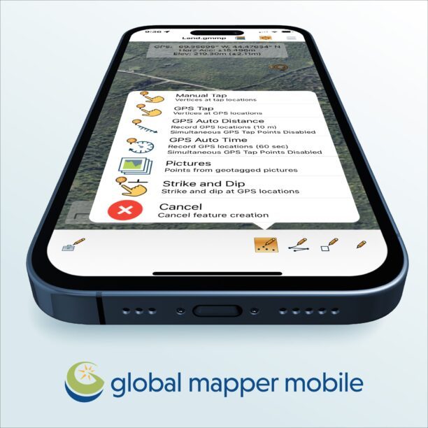
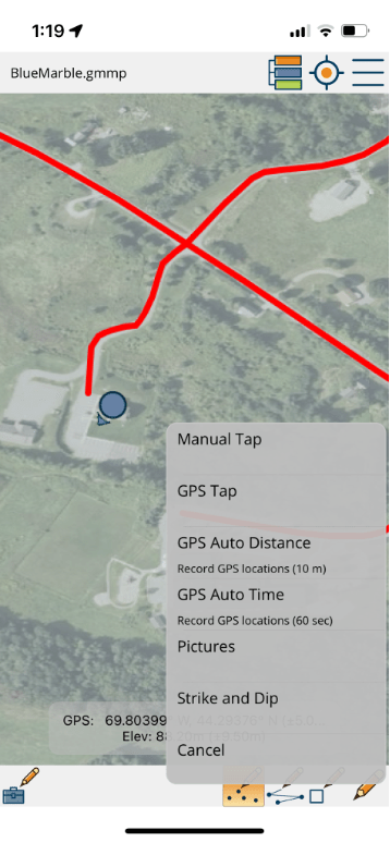
Global Mapper Mobile, a free download from the App Store and Google Play Store, allows users to begin collecting data using the internal location services of the mobile device. This can be done in an empty map space or with a basemap from an online source loaded. Vector feature digitizing in Global Mapper Mobile includes methods for manual drawing on the map as well as GPS informed point, line, and area feature creation. Once added to the map attributes and images can be added, and edited, to store additional field information.

To take the use of Global Mapper Mobile further, consider adding the Pro Module. A yearly subscription at a nominal fee, the Pro module unlocks a variety of useful tools for field GIS work including Advanced GPS connection to external GNSS devices, geocoding, quick data analysis tools, and more!

While the use of a mobile device internal location services is convenient, for high-accuracy ground control point collection, a higher-end external positioning device can be used with Global Mapper Mobile Pro. By connecting an external GNSS device via bluetooth or IP port configuration, Global Mapper Mobile will use the position from the external device, even applying RTK correction if compatible and setup though the app’s built-in NTRIP client. With each version of Global Mapper Mobile the tested and supported list of external positioning devices grows. More information on supported devices can be found in the iOS and Android help pages for the app.

Expanding on the utility of Global Mapper Mobile in the field, the Pro Module contains a small set of analysis tools. These tools include viewshed analysis, volume calculation, and, in the new version 3.0 of the app, contour generation. Mimicking the versions of these tools one would find in the Global Mapper Pro desktop software, the mobile version of these tools are optimized for quick use in the field. Viewshed analysis, volume calculation, and contour generation all rely on a terrain data layer in the mobile map to provide information and context about the area when working in the field.

To explore Global Mapper Mobile download the app from the iOS App Store or Google Play Store today! Find out more about Global Mapper Mobile, the Pro Module, and other software products from Blue Marble Geographics at www.bluemarblegeo.com.

Read more:

  • Check Out These New Features in Global Mapper v25 from Blue Marble
  • From the Floor of Intergeo: Blue Marble Global Mapper V24, More Resolution, More Speed
Miriam McNabb

Miriam McNabb is the Editor-in-Chief of DRONELIFE and CEO of JobForDrones, a professional drone services marketplace, and a fascinated observer of the emerging drone industry and the regulatory environment for drones. Miriam has penned over 3,000 articles focused on the commercial drone space and is an international speaker and recognized figure in the industry.  Miriam has a degree from the University of Chicago and over 20 years of experience in high tech sales and marketing for new technologies.
For drone industry consulting or writing, Email Miriam.

TWITTER:@spaldingbarker

Subscribe to DroneLife here.

Filed Under: News, Sponsored Content Tagged With: Android GIS app, Blue Marble Geographics, drone data collection, GIS field tools, Global Mapper Mobile, GPS mapping app, high-accuracy ground control points, iOS GIS app, mobile GIS software, Pro Module features

Reader Interactions

Leave a Reply Cancel reply

Your email address will not be published. Required fields are marked *

Primary Sidebar

LATEST

FCC Updates Covered List, Introduces First Conditional Approvals for Drone Systems

Four systems receive time-limited approvals as a new case-by-case pathway takes shape News and Commentary.  The Federal Communications Commission (FCC)…

Continue Reading FCC Updates Covered List, Introduces First Conditional Approvals for Drone Systems

Volatus Aerospace Graduates to Toronto Stock Exchange

Volatus Aerospace Inc. will graduate to the Toronto Stock Exchange on March 20, 2026, trading under the symbol FLT. The…

Continue Reading Volatus Aerospace Graduates to Toronto Stock Exchange

Windracers ULTRA to Map Greenland’s Petermann Glacier

By Dronelife Features Editor Jim Magill An international team of researchers plans to deploy Windracers’ dual-use heavy-lift drone technology to…

Continue Reading Windracers ULTRA to Map Greenland’s Petermann Glacier

Africa Pavilion to Debut at XPONENTIAL Europe 2026

African Drone Forum initiative highlights growing role of African innovators in global autonomy ecosystem The African Drone Forum (ADF) has…

Continue Reading Africa Pavilion to Debut at XPONENTIAL Europe 2026

Everdrone Raises SEK 36 Million to Expand Drone-Based Emergency Healthcare Services

Funding supports commercialization and expansion of drone-delivered medical response systems across Europe Everdrone has raised SEK 36 million in a…

Continue Reading Everdrone Raises SEK 36 Million to Expand Drone-Based Emergency Healthcare Services

Palantir, Ondas, and World View Partner on Multi-Domain ISR Integration

Palantir Technologies, Ondas Inc., and World View Enterprises have announced a strategic partnership to develop an AI-enabled operational architecture for multi-domain…

Continue Reading Palantir, Ondas, and World View Partner on Multi-Domain ISR Integration

Alpine Eagle Scales Counter-Drone Production as European Demand Grows

Sentinel system expansion reflects rising need for deployable, cost-effective air defense solutions Alpine Eagle, a European counter-drone technology company, is…

Continue Reading Alpine Eagle Scales Counter-Drone Production as European Demand Grows

Fortem DroneHunter and TrueView Radar Join Lockheed Martin Sanctum

Fortem Technologies has announced a new contract with Lockheed Martin to deploy autonomous counter-drone systems for critical infrastructure protection. The…

Continue Reading Fortem DroneHunter and TrueView Radar Join Lockheed Martin Sanctum

DHS Taps Fortem for Kinetic Counter-UAS Systems at World Cup Venues

By Dronelife Features Editor Jim Magill (Editor’s note: This story is part of a series of reports on efforts to…

Continue Reading DHS Taps Fortem for Kinetic Counter-UAS Systems at World Cup Venues

DroneShield Integrates Robin Radar for Layered Drone Airspace Protection

DroneShield has announced a new partnership with Robin Radar Systems to expand its counter-UAS sensor ecosystem. The agreement integrates Robin’s…

Continue Reading DroneShield Integrates Robin Radar for Layered Drone Airspace Protection

Secondary Sidebar

Footer

SPONSORED

Inspired Flight Gremsy IF800 VIO F1 drones geo week

What Will It Take to Strengthen U.S. Drone Manufacturing? A Conversation with Inspired Flight’s CEO

Military Drone Mapping Solutions

How SimActive’s Correlator3D™ is Revolutionizing Military Mapping: An Exclusive Interview with CEO Philippe Simard

Photogrammetry Accuracy Standards

SimActive Photogrammetry Software: Enabling Users to Meet Accuracy Standards for Over 20 Years

NACT Engineering Parrot ANAFI tether indoor shot

Smart Tether for Parrot ANAFI USA from NACT Engineering

Blue Marble, features global mapper, features Blue Marble

Check Out These New Features in Global Mapper v25 from Blue Marble

Blue Marble Graphics, Blue Marble Mobile Mapper

Global Mapper Mobile: Streamlining Data Collection and Processing

About Us | Contact Us | Advertise With Us | Write for Us | Privacy Policy | Terms of Service

The Trusted Source for the Business of Drones.

This website uses cookies and third party services. By clicking OK, you are agreeing to our privacy policy. ACCEPT

Manage consent

Privacy Overview

This website uses cookies to improve your experience while you navigate through the website. Out of these, the cookies that are categorized as necessary are stored on your browser as they are essential for the working of basic functionalities of the website. We also use third-party cookies that help us analyze and understand how you use this website. These cookies will be stored in your browser only with your consent. You also have the option to opt-out of these cookies. But opting out of some of these cookies may affect your browsing experience.
Necessary
Always Enabled
Necessary cookies are absolutely essential for the website to function properly. These cookies ensure basic functionalities and security features of the website, anonymously.
CookieDurationDescription
cookielawinfo-checkbox-analytics11 monthsThis cookie is set by GDPR Cookie Consent plugin. The cookie is used to store the user consent for the cookies in the category "Analytics".
cookielawinfo-checkbox-functional11 monthsThe cookie is set by GDPR cookie consent to record the user consent for the cookies in the category "Functional".
cookielawinfo-checkbox-necessary11 monthsThis cookie is set by GDPR Cookie Consent plugin. The cookies is used to store the user consent for the cookies in the category "Necessary".
cookielawinfo-checkbox-others11 monthsThis cookie is set by GDPR Cookie Consent plugin. The cookie is used to store the user consent for the cookies in the category "Other.
cookielawinfo-checkbox-performance11 monthsThis cookie is set by GDPR Cookie Consent plugin. The cookie is used to store the user consent for the cookies in the category "Performance".
viewed_cookie_policy11 monthsThe cookie is set by the GDPR Cookie Consent plugin and is used to store whether or not user has consented to the use of cookies. It does not store any personal data.
Functional
Functional cookies help to perform certain functionalities like sharing the content of the website on social media platforms, collect feedbacks, and other third-party features.
Performance
Performance cookies are used to understand and analyze the key performance indexes of the website which helps in delivering a better user experience for the visitors.
Analytics
Analytical cookies are used to understand how visitors interact with the website. These cookies help provide information on metrics the number of visitors, bounce rate, traffic source, etc.
Advertisement
Advertisement cookies are used to provide visitors with relevant ads and marketing campaigns. These cookies track visitors across websites and collect information to provide customized ads.
Others
Other uncategorized cookies are those that are being analyzed and have not been classified into a category as yet.
SAVE & ACCEPT