 Drones Dominated the Geo Week ‘24 Floor
By: Dawn Zoldi
Geo Week distinguishes itself as the leading event fostering improved cooperation among specialists in the built environment, advanced airborne/terrestrial technologies and enthusiasts of commercial 3D technology. The event originated in response to the evolving needs of professionals in the built world and geospatial domains and continues to illustrate the evolutionary integration of a wide variety of technologies. Across the nearly 200 top companies and organizations in the industry showcased this year’s expo hall, drones stood at the epicenter. Want to know which drones geospatial professionals use as their go-tos? Check out this overview of the drones that dominated on the Geo Week floor.
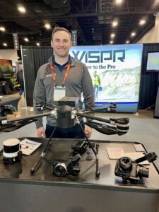 WISPR Systems – SkyScout
At Geo Week, WISPR introduced its new revolutionary SkyScout drone. Boasting an impressive flight time of 26-30 minutes with smart and plane-safe hot-swappable batteries that enable uninterrupted operations, the company equipped this high resolution mapping drone with a failsafe feature that triggers at 25% battery level for enhanced safety and reliability. Additive to its endurance profile, the SkyScout weighs in at only 4.7 lbs. This compact form factor makes for easy portability and effortless transport to almost any location. This drone combines intelligence into this sleek design. With Here4 and HerePro GNSS antenna options, it offers precise RTK and PPK geotagging capabilities that ensure accurate data collection. The SkyScout drone also provides versatility with multiple payload options that allow for its use across a wide range of aerial missions such as the WISPR 24MP Mapper, the company’s cutting-edge imaging solution.
Microdrones – The EasyOne
Microdrones unveiled its latest offering at Geo Week, the EasyOne, its most advanced LiDAR drone surveying equipment yet. A few distributors, like Colorado-based Vectors Inc., featured this compact drone crafted for survey-grade tasks, this one is chock full of cutting-edge features and cutting-edge 4th-generation drone technology. For example, it comes with a “Real Time Terrain Follow” function for heightened precision and seamless integration with Microdrones’ LP360 software for accurate LiDAR data processing. This drone suits diverse applications and simplifies the entire process of planning, flying, collecting, processing, and visualizing your geospatial data projects. Users will also enjoy the convenience of acquiring the entire system, consisting of the drone, payload, controller, and battery, all within a single, compact 35 pound package.
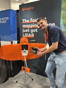 Wingtra – WingtraOne Gen II
The distinctive features of the autonomous eVTOL fixed-wing WingtraOne GEN II mapping drone include its ability to fly at a speed of 16 m/s (36 mph) for up to 59 minutes per flight, allowing for extensive coverage of large areas. The system features easy-to-swap payloads covering the entire range of a typical project workflow, including oblique and a high-efficiency 61 MP camera. With its onboard high-precision PPK GNSS receiver, the WingtraOne enables capture of more accurate location information per picture, across large coverage areas per flight. This drone also boasts data collection speeds up to 11 times faster than multicopter drones and up to twice as fast as standard fixed-wing drones. At Geo Week, Wingtra announced the launch of its new Wingtra LiDAR drone payload, which provides users with a total solution—from site planning all the way through to management and maintenance. Through the integration of leading-edge components such as a top-tier Hesai scanner, Inertial Labs IMU, and NovAtel GNSS, this LIDAR package diminishes the necessity for labor-intensive post-processing strip alignment and streamlines field operations with one-minute push-button calibration and initialization. With its user-friendly app and automated features, Wingtra LIDAR echoes a key Wingtra objective of making data capture simple, even for beginners. In fact, it saves a minimum of one hour per survey compared to other similar systems.
Quantum Systems – Trinity Pro
Quantum Systems’ globally proven eVTOL mapping solution, the Trinity Pro, provides a dependable, user-friendly and secure platform for aerial data collection. Introduced to the market in 2018, users have logged in more than 75,000 flight hours with this drone on a global scale. Given the company’s work with the U.S. Department of Defense and other militaries, the Trinity Pro includes advanced capabilities such as a cutting-edge autopilot (the Quantum-Skynode) with an onboard Linux mission computer, expanded internal storage, enhanced connectivity and readiness for downstream AI applications.
At the show, the company also introduced its next-gen LiDAR Scanner, the Qube 640. According to Claudia Steinhoff Head of Corporate Communications & Marketing for Quantum Systems (live from the Geo Week floor), “Paired with our Trinity Pro fixed-wing eVTOL, this is the most efficient drone-based LiDAR system in the market. Quantum Systems is committed to bring cutting edge technology to aerial surveyors and enhance decision making in a variety of industries, including the U.S. DoD.”
 Skyfront – Perimeter 8+
Skyfront’s Perimeter 8+, a large fuel-injected hybrid long endurance drone, boasts impressive capabilities. The company showcased its even more enhanced capabilities. Now capable of accommodating payloads exceeding 11 pounds (5 kilograms) for 2-3 hours, this drone supports various form factors, including LiDAR units, visual and thermal cameras, and other equipment. With no payload, the Perimeter 8+ has an overall flight endurance of over 5 hours. Its video and control range spans 60 miles (or 100 kilometers). Optional drone add-ons include: GPS jamming defense and data link anti-jamming capabilities to operate in GNSS/GPS and communication-denied areas; hot weather operation features for extreme environments with temperatures reaching up to 50°C; command and control (C2) handoff capability; navigational RTK GNSS systems for centimeter-level accuracy; active terrain following with active RADAR altimeters to maintain precise altitude above ground level; and battery-only flight time options for extended reserve flight times. With a setup time of less than 5 minutes, this easy-to-use hybrid drone’s combination of heavy-lifting capability and extended endurance significantly cuts down field time from days to hours, across a variety of tasks and applications.
Harris Aerial – Carrier H6
Harris Aerial featured its Carrier H6 family of drones, a high-capacity hexacopter that comes in multiple configurations all popular for LiDAR surveying, photogrammetry, utility inspections, large corridor mapping, surveillance and more. This adaptable platform supports three power formats: gasoline, hydrogen-electric (Hydrone) and fully electric.The company’s Carrier H6 Hybrid Electronic Fuel Injection (EFI) configuration is powered by a 2-stroke gasoline H2400EFI generator that can sustain flights of up to 2.5 hours with a 5kg payload. The Carrier H6 Electric features an innovative battery rack system and is powered by advanced lithium polymer smart 12S1P 16,000 mAh Lithium Polymer batteries, enabling it to deliver flight times of up to 48 minutes. The Carrier H6 Hydrone with Phoenix LiDAR Option, the company’s latest hybrid electric drone, features a hydrogen fuel cell power source: Intelligent Energy’s 2.4kw FCPM. It can fly for up to 2.5 hours with a recommended 3kg payload or up to 1.5 hours with a maximum 5kg payload. Harris Aerial’s versatile Carrier platforms will support various payloads, including scientific-grade sensors like multispectral cameras, professional DSLRs for cinematography, and LiDAR. And all three of these drones can seamlessly adapt with any of the Carrier H6 power formats in just minutes.
FreeFly Systems – AltaX and Astro
Frontier Precision, the pre-eminent reseller – distributor serving survey, mapping, engineering, construction, GIS professionals throughout the western U.S., had several drones (and other robots, and LiDARs and the “Spot” Q-UGV etc.) in their booth at Geo Week. Among these, the company featured FreeFly Systems’ AltaX and Astro. The AltaXdrone operates using just two batteries that deliver up to 50 minutes of flight time without a payload and 22 minutes with a 20-pound payload. Its other impressive features include: a max payload capacity of 35 pounds; quick-release payload mounting system; adjustable Vibration Isolation options; Long Range Data link; extensive accessory ecosystem; 33-inch vibration-minimizing blades (ActiveBlade technology); quick-folding capability (it folds to half its size with one-finger folding!); and flexible software stack equally (Auterion Enterprise PX4, supporting the MAVSDK).
The Astro is FreeFly’s more compact industrial drone. Featuring flight durations of 37 minutes without a payload and up to 25 minutes with a 1.5kg payload, this platform is outfitted with RTK capability, a 61-megapixel Sony camera, LTE cloud connectivity, a mission computer and additional advanced features. This drone also folds to 16” x 16” x 6” for ease of transport.
Skydio – X10
Frontier Precision also hosted Skydio’s X10. With superior megapixels and enhanced optics compared to drones of similar dimensions, the Skydio X10 showcases high-resolution visual and radiometric cameras housed within a modular sensor package. This AI-enabled smart drone uses an innovative Spatial AI Engine which intuitively detects and comprehends the objects being scanned to seamlessly generate 2D maps and 3D models directly onboard, in real-time – all while getting smarter over time. Alternatively, surveying and mapping users can also export data to platforms like Pix4D, Bentley iTwin Capture, DroneDeploy, or ESRI SiteScan for further analysis and visualization. Users can also integrate the X10 with the Skydio 3D Scan™ App to create digital twins, whether indoors or outdoors. Supported by an onboard NVIDIA Jetson Orin GPU, the X10 utilizes unparalleled computational capabilities to make instantaneous decisions. With six specially crafted navigation lenses offering complete 360-degree visibility, the X10 eradicates navigational blind spots in any setting.
 Inspired Flight – IF800 Tomcat
Inspired Flight’s IF800 Tomcat medium lift drone comes equipped with impressive capabilities for extended mapping and surveying aerial operations. With a maximum flight time of 54 minutes, it can carry a maximum payload capacity of 6.6 pounds while accommodating various payloads for diverse applications. With a top speed of 49 miles per hour and a maximum wind resistance of 23 knots, the IF800 Tomcat delivers swift and stable performance even in challenging conditions. It provides a selection of pre-integrated payloads, including optical, EO/IR and LiDAR, all tailored to individual industries. For LiDAR operators, this platform is known for its stability, and minimal vibration characteristics ideal for these delicate payloads. For photogrammetry, the Tomcat automatically embeds geotagged metadata onto images and camera SD cards as well as supports an optional RTK/PPK module for mapping and surveying accuracy down to centimeter-level precision.
And More…
To be sure, Geo Week featured other drones and tech not described here. The boundaries of geospatial technologies and their myriad applications extend well beyond drones in the sky. Companies offer services that use equipment and vehicles that traverse the land and water – including subsurface – all equipped with a wide variety of advanced sensors and software. This seamless integration of high-tech tools has simplified critical geospatial data acquisition and utilization like never before. Even so, drones absolutely dominated the show floor this year…and will undoubtedly continue to soar in the field.
 Dawn M.K. Zoldi (Colonel, USAF, Retired) is a licensed attorney with 28 years of combined active duty military and federal civil service to the U.S. Air Force. She is the CEO & Founder of P3 Tech Consulting and an internationally recognized expert on uncrewed aircraft system law and policy. Zoldi contributes to several magazines and hosts popular tech podcasts. Zoldi is also an Adjunct Professor for two universities, at the undergraduate and graduate levels. In 2022, she received the Airwards People’s Choice Industry Impactor Award, was recognized as one of the Top Women to Follow on LinkedIn and listed in the eVTOL Insights 2022 PowerBook. For more information, follow her on social media and visit her website at: https://www.
Read more:
- Skydio X10’s Custom Thermal Payload: 48% Less Weight, More Resolution
- Wingtra Introduces Advanced LIDAR Drone Solution for Precision Mapping
- Skyfront Perimeter 8 Receives First Green UAS Certification from AUVSI
- The New IF 800 TOMCAT is Newest and Best of Inspired Flight’s Technology

Miriam McNabb is the Editor-in-Chief of DRONELIFE and CEO of JobForDrones, a professional drone services marketplace, and a fascinated observer of the emerging drone industry and the regulatory environment for drones. Miriam has penned over 3,000 articles focused on the commercial drone space and is an international speaker and recognized figure in the industry. Miriam has a degree from the University of Chicago and over 20 years of experience in high tech sales and marketing for new technologies.
For drone industry consulting or writing, Email Miriam.
TWITTER:@spaldingbarker
Subscribe to DroneLife here.


[…] Источник […]