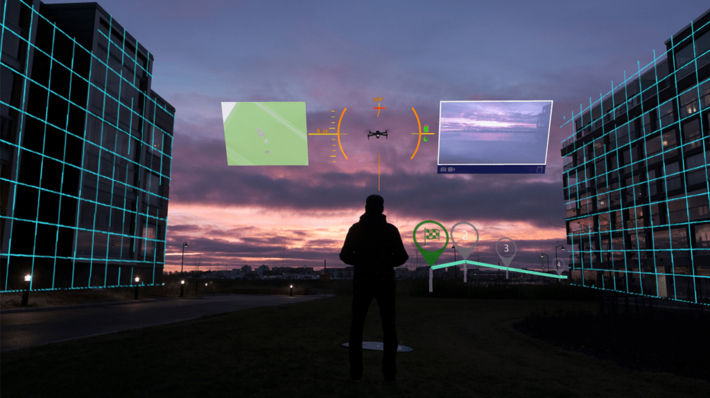
The concept of drone flight within visual line of sight or with visual observers points out a significant issue for drone pilots. Pilots must maintain an understanding of the data on their controller while also being aware of where the drone is in real space. The Anarky Labs’ AIRHUD augmented realityplatform offers an elegant solution: putting the airspace awareness data that pilots need into the sky with a “heads up” display.
DRONELIFE spoke with Hannu Lesonen, Founder and CEO of Anarky Labs, and expert drone pilot Stephen Sutton of FlyBy Guys. We also had the opportunity to experience AIRHUD for ourselves on the floor of Amsterdam Drone Week.
The Heads Up Display: Visual Understanding of Airspace, Ground Context, and More
AIRHUD is a subscription software product installed on smart controller and glasses including MetaQuest Pro or Microsoft Hololens 2. It’s a feature rich solution that offers pilots an easy way of absorbing the information they need for safety – and for a precise and effective flight for their customer.
With AIRHUD, pilots can see their drone in the context of spatial reality and regulations. (Regulations are integrated from UTM providers, including Altitude Angel and Aviamaps.) Visual indicators pinpoint the drone in the sky with elements including height and heading, so pilots never again have to guess which way their drone is pointing. All the basics like battery life are clear, as are regulatory limitations: an altitude limit becomes a red ceiling over the drone, while the appropriate distance to maintain from a structure is a visual wall. The real time video displays beside the aircraft; and a map of the area, showing streets and structures, indicates where the drone is in real geography. You can see waypoints in their positions on the map, evaluating the safety of a waypoint mission that may have trees or buildings in the vicinity – or drop a point on the map with your finger to note a place of interest.
“It’s about understanding where the drone actually is,” says Lesonen. “It’s about making totally abstract things more concrete.”
With a few minutes of practice, DRONELIFE got the hang of toggling back and forth between options and absorbing data through the VR glasses. For beginners or training applications, it’s an incredibly easy way to visually understand regulations in context with drone flight. For experienced pilots working on precise inspection applications, public safety, or other jobs, the AIRHUD offers a tool that takes operations to the next level.
Stephen Sutton is Chief Pilot at FlyBy Guys, a full stack drone consultancy offering services that range from inspection to drone shows. Sutton says that AIRHUD is a game changer for commercial applications.
“It’s all about the data, and what you can see in the sky,” says Sutton. “When you are doing industrial inspections, being able to see the drone constantly is really important – you’re always making sure that you are a sufficient distance from turbines, or the right distance from the mast. With AIRHUD, we’re able to keep our eyes in the sky, instead of looking up and down… It’s incredible situational awareness, and it’s immensely helpful in making flights more effective.”
In addition to asset inspection use cases, several national law enforcement agencies around the world are testing the system. For public safety agencies flying BVLOS, being able to use contextual information like the city map to “see through” buildings, and to see where the drone is in relation to buildings or trees, is a major benefit. Incident commanders can use the map function combined with the streaming video to better understand the likely path of a moving suspect, or an evolving traffic or vehicle related incident: or to plan security missions.
Drone training is another huge opportunity for AIRHUD, and several national-level programs are evaluating the system now. “The AIRHUD is by far one of the most realistic ways to visualize drone flight and be visually aware of the regulations,” says Lesonen. “In the classroom, you can use real sticks with a virtual drone in a virtual environment; outdoors, you can use real sticks with a virtual drone in a virtual environment; and pilots can work towards using a real drone in real environment.”
“It’s totally safe, and totally convincing,” he comments.
Ultimately, AIRHUD makes missions more effective – but improved operational safety may be the biggest selling point. “This definitely enhances safety,” says Sutton. “You never have to panic when you see an oncoming aircraft, because you know exactly where your drone is. You know where you are and which way your drone is pointing. It makes it so much easier.”
AIRHUD is available now on commercial DJI drones including the Mavic family: AIRHUD is platform agnostic, and will support most commercial platforms with SDK.
Check out this video of the AirHUD augmented reality platform:
Read more:
- Is AR the Future of BVLOS Flight? The Flyby Guys and Anarky Labs Unveil Drone AR Solution for DJI [VIDEO]
- FlyBy Guys Expand to Dubai: Drone Expertise Going Global
- Pharmacy Drone Delivery: Flyby Guys Lead Pilot Project in Helsinki
- This is Cool: Echodyne Demonstrates Augmented Reality for Airspace Awareness
- Epson’s Augmented Reality Glasses Are a Revolution in Drone Tech
Miriam McNabb is the Editor-in-Chief of DRONELIFE and CEO of JobForDrones, a professional drone services marketplace, and a fascinated observer of the emerging drone industry and the regulatory environment for drones. Miriam has penned over 3,000 articles focused on the commercial drone space and is an international speaker and recognized figure in the industry. Miriam has a degree from the University of Chicago and over 20 years of experience in high tech sales and marketing for new technologies.
For drone industry consulting or writing, Email Miriam.
TWITTER:@spaldingbarker
Subscribe to DroneLife here.
