• Skip to main content
  • Skip to secondary menu
  • Skip to primary sidebar
  • Skip to secondary sidebar
  • Skip to footer
  • DroneRacingLife
  • DroneFlyers
  • Newsletter
DroneLife

DRONELIFE

Stay up to date on all the latest Drone News

  • News
  • Products
  • Industries
    • Agriculture
    • Construction
    • Delivery
    • Dual Use
    • Inspection
    • Public Safety
    • Surveying
  • Enthusiasts
  • Regulations
  • Business
  • Video
  • Podcasts

TOPODRONE Launches AQUAMAPPER: Airborne Bathymetric Surveying Solution

October 19, 2022 by Miriam McNabb 10 Comments

TOPODRONE Launches AQUAMAPPER Airborne Bathymetric Surveying Solution

by DRONELIFE Staff Writer Ian M. Crosby

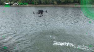
At global mapping show INTERGEO this week, LiDAR equipment company TOPODRONE has launched AQUAMAPPER, a UAV-based solution for bathymetric surveying and marine construction.  Bathymetric surveying is the underwater equivalent of topographic surveying, mapping the floor of rivers, lakes and oceans.  The new multitasking data collecting device has been successfully deployed alongside TOPODRONE LiDAR ULTRA equipment for the airborne surveying of a Romanian highway construction project in order to provide a digital twin of a scanned area.

The new AQUAMAPPER hardware integrates with other technology to form a comprehensive set of photogrammetry, LiDAR and bathymetry surveying solutions. Upon being mounted to a UAV, AQUAMAPPER offers high speed efficiency (up to 14 km/h) and accuracy. The PPK ready solution is also compatible with DJI Matrice 300 RTK. The hardware can be deployed for a wide range of use cases, including an open sea bathymetric survey up to 100m depth, quantity survey and calculation of sediments, and periodic maintenance survey of storage pools.

TOPODRONE AQUAMAPPER and LiDAR ULTRA have been deployed in an airborne surveying mission at “Autostrada Sibiu – Pitești, Secțiunea 2: Boița – Cornetu”, a European road construction project. The project seeks to construct a highway in one of Romania’s most rugged environments, and incorporates 7 tunnels, 24 bridges and 18 viaducts. The drone LiDAR corridor and bathymetric survey was conducted by Romanian company GRAPHEIN TOPO SA in order to produce accurate maps and current information regarding terrain level, buildings, roads, power line networks, cadastral boundaries, and rivers. TOPODRPONE’s LiDAR ULTRA was deployed on board a DJI M300 drone, and was utilized to collect laser scanning data from 100 – 120 meters above the forested terrain, covering a 32 km long and 400 meters wide corridor over the course of 14 flights. At the same time, AQUAMAPPER hardware attached to the same drone conducted a bathymetry survey over 6 river crossings.

“The key advantage of the new bathymetric equipment from TOPODRONE is the ability to capture a riverbed with centimeters level accuracy with high speed in fully automatic mode and without using any boat. It allows us to work in hard to access and shallow water areas,” said Andrei Sueran, GRAPHEIN TOPO SA. “The same drone carrier can be used for both LiDAR & bathymetry surveys. The combination of an echosounder, GNSS and Inertial measurement system helps to get accurate results after data post processing.”

Read more about drone payloads for aquatic missions:

  • From the Floor of Intergeo: Amuse Oneself, Green Light LiDAR for Aquatic Applications
  • Robonomics Floats Aquatic Drones to Scan Water Quality
  • Aquabotix Signs Deal to Deploy Mine-hunting Aquatic Drones
  • NOAA Launches Autonomous Drones to Study the Bering Sea

Ian attended Dominican University of California, where he received a BA in English in 2019. With a lifelong passion for writing and storytelling and a keen interest in technology, he is now contributing to DroneLife as a staff writer.


Miriam McNabb

Miriam McNabb is the Editor-in-Chief of DRONELIFE and CEO of JobForDrones, a professional drone services marketplace, and a fascinated observer of the emerging drone industry and the regulatory environment for drones. Miriam has penned over 3,000 articles focused on the commercial drone space and is an international speaker and recognized figure in the industry.  Miriam has a degree from the University of Chicago and over 20 years of experience in high tech sales and marketing for new technologies.
For drone industry consulting or writing, Email Miriam.

TWITTER:@spaldingbarker

Subscribe to DroneLife here.

Filed Under: Drone News, Drone News Feeds, News

Reader Interactions

Trackbacks

  1. Drone Information of the Week October 21 says:
    October 22, 2022 at 11:26 am

    […] TOPODRONE Launches AQUAMAPPER: Airborne Bathymetric Surveying Resolution […]

    Reply
  2. Drone News of the Week, October 21: DRONELIFE Headlines, All in One Place to Read or Listen - SkyDance Imaging says:
    October 21, 2022 at 3:02 pm

    […] TOPODRONE Launches AQUAMAPPER: Airborne Bathymetric Surveying Solution […]

    Reply
  3. Drone Information of the Week October 21 - Natli Tech says:
    October 21, 2022 at 10:04 am

    […] TOPODRONE Launches AQUAMAPPER: Airborne Bathymetric Surveying Answer […]

    Reply
  4. Drone Information of the Week October 21 says:
    October 21, 2022 at 7:29 am

    […] TOPODRONE Launches AQUAMAPPER: Airborne Bathymetric Surveying Answer […]

    Reply
  5. TOPODRONE Launches AQUAMAPPER: Airborne Bathymetric Surveying Solution – FPVSKY says:
    October 21, 2022 at 6:58 am

    […] post TOPODRONE Launches AQUAMAPPER: Airborne Bathymetric Surveying Solution appeared first on […]

    Reply
  6. TOPODRONE Launches AQUAMAPPER – DRONELIFE says:
    October 20, 2022 at 10:12 am

    […] More… […]

    Reply
  7. TOPODRONE Launches AQUAMAPPER - DRONELIFE - Fantastin says:
    October 20, 2022 at 1:29 am

    […] Source link […]

    Reply
  8. TOPODRONE Launches AQUAMAPPER – DRONELIFE – dagoldinfo says:
    October 19, 2022 at 2:35 pm

    […] Miriam McNabb is the Editor-in-Chief of DRONELIFE and CEO of JobForDrones, a professional drone services marketplace, and a fascinated observer of the emerging drone industry and the regulatory environment for drones. Miriam has penned over 3,000 articles focused on the commercial drone space and is an international speaker and recognized figure in the industry.  Miriam has a degree from the University of Chicago and over 20 years of experience in high tech sales and marketing for new technologies.For drone industry consulting or writing, Email Miriam. […]

    Reply
  9. TOPODRONE Launches AQUAMAPPER - DRONELIFE - Game Up News says:
    October 19, 2022 at 2:00 pm

    […] Source link […]

    Reply
  10. TOPODRONE Launches AQUAMAPPER: Airborne Bathymetric Surveying Solution - UAV FL says:
    October 19, 2022 at 1:48 pm

    […] post TOPODRONE Launches AQUAMAPPER: Airborne Bathymetric Surveying Solution appeared first on […]

    Reply

Leave a Reply Cancel reply

Your email address will not be published. Required fields are marked *

Primary Sidebar

LATEST

BRINC Launch Signals Next Phase of U.S. Public Safety Drone Industry

New Guardian platform and Seattle factory highlight scaling pressure, public safety adoption, and policy shifts shaping the U.S. drone market.…

Continue Reading BRINC Launch Signals Next Phase of U.S. Public Safety Drone Industry

Red Force as a Service Brings Realistic Counter-UAS Testing to Pendleton

Pendleton UAS Range (PUR) and Gambit have partnered to deliver Red Force as a Service for counter-UAS testing, validation, and…

Continue Reading Red Force as a Service Brings Realistic Counter-UAS Testing to Pendleton

Unifly Expands European Drone Consulting with New Acquisition

Unifly acquires EuroUSC-Benelux to expand drone regulatory and compliance consulting across Belgium, the Netherlands, Luxembourg, and France. Unifly, a global…

Continue Reading Unifly Expands European Drone Consulting with New Acquisition

Photojournalist Challenges FAA Temporary Flight Restriction as First Amendment Violation

By Dronelife Features Editor Jim Magill A drone pilot has sued the FAA, claiming that an FAA temporary flight restriction…

Continue Reading Photojournalist Challenges FAA Temporary Flight Restriction as First Amendment Violation

Terra Drone Announces Entry into Defense Market with Planned U.S. Subsidiary

Company outlines strategy to expand unmanned systems across global defense markets Tokyo-based Terra Drone Corporation has announced a full-scale entry…

Continue Reading Terra Drone Announces Entry into Defense Market with Planned U.S. Subsidiary

China Leads Global Surge in Counter-Drone Patents as Security Concerns Grow

New data highlights rising investment in jamming, laser, and microwave systems as governments and industry seek scalable drone defense solutions…

Continue Reading China Leads Global Surge in Counter-Drone Patents as Security Concerns Grow

Texas A&M Team Uses Drones to Map Ocean Currents

By Dronelife Features Editor Jim Magill When an offshore platform experiences a massive blowout resulting in an oil spill covering…

Continue Reading Texas A&M Team Uses Drones to Map Ocean Currents

ePropelled Opens UK Hub to Scale UAV Propulsion

ePropelled has opened its new Global Innovation Centre in Coventry, expanding capacity for UAV propulsion and power systems. The facility…

Continue Reading ePropelled Opens UK Hub to Scale UAV Propulsion

FCC Updates Covered List, Introduces First Conditional Approvals for Drone Systems

Four systems receive time-limited approvals as a new case-by-case pathway takes shape News and Commentary.  The Federal Communications Commission (FCC)…

Continue Reading FCC Updates Covered List, Introduces First Conditional Approvals for Drone Systems

Volatus Aerospace Graduates to Toronto Stock Exchange

Volatus Aerospace Inc. will graduate to the Toronto Stock Exchange on March 20, 2026, trading under the symbol FLT. The…

Continue Reading Volatus Aerospace Graduates to Toronto Stock Exchange

Secondary Sidebar

Footer

SPONSORED

Inspired Flight Gremsy IF800 VIO F1 drones geo week

What Will It Take to Strengthen U.S. Drone Manufacturing? A Conversation with Inspired Flight’s CEO

Global Mapper Mobile data collection

Collection Ground Control Points with Global Mapper Mobile

Military Drone Mapping Solutions

How SimActive’s Correlator3D™ is Revolutionizing Military Mapping: An Exclusive Interview with CEO Philippe Simard

Photogrammetry Accuracy Standards

SimActive Photogrammetry Software: Enabling Users to Meet Accuracy Standards for Over 20 Years

NACT Engineering Parrot ANAFI tether indoor shot

Smart Tether for Parrot ANAFI USA from NACT Engineering

Blue Marble, features global mapper, features Blue Marble

Check Out These New Features in Global Mapper v25 from Blue Marble

About Us | Contact Us | Advertise With Us | Write for Us | Privacy Policy | Terms of Service

The Trusted Source for the Business of Drones.

This website uses cookies and third party services. By clicking OK, you are agreeing to our privacy policy. ACCEPT

Manage consent

Privacy Overview

This website uses cookies to improve your experience while you navigate through the website. Out of these, the cookies that are categorized as necessary are stored on your browser as they are essential for the working of basic functionalities of the website. We also use third-party cookies that help us analyze and understand how you use this website. These cookies will be stored in your browser only with your consent. You also have the option to opt-out of these cookies. But opting out of some of these cookies may affect your browsing experience.
Necessary
Always Enabled
Necessary cookies are absolutely essential for the website to function properly. These cookies ensure basic functionalities and security features of the website, anonymously.
CookieDurationDescription
cookielawinfo-checkbox-analytics11 monthsThis cookie is set by GDPR Cookie Consent plugin. The cookie is used to store the user consent for the cookies in the category "Analytics".
cookielawinfo-checkbox-functional11 monthsThe cookie is set by GDPR cookie consent to record the user consent for the cookies in the category "Functional".
cookielawinfo-checkbox-necessary11 monthsThis cookie is set by GDPR Cookie Consent plugin. The cookies is used to store the user consent for the cookies in the category "Necessary".
cookielawinfo-checkbox-others11 monthsThis cookie is set by GDPR Cookie Consent plugin. The cookie is used to store the user consent for the cookies in the category "Other.
cookielawinfo-checkbox-performance11 monthsThis cookie is set by GDPR Cookie Consent plugin. The cookie is used to store the user consent for the cookies in the category "Performance".
viewed_cookie_policy11 monthsThe cookie is set by the GDPR Cookie Consent plugin and is used to store whether or not user has consented to the use of cookies. It does not store any personal data.
Functional
Functional cookies help to perform certain functionalities like sharing the content of the website on social media platforms, collect feedbacks, and other third-party features.
Performance
Performance cookies are used to understand and analyze the key performance indexes of the website which helps in delivering a better user experience for the visitors.
Analytics
Analytical cookies are used to understand how visitors interact with the website. These cookies help provide information on metrics the number of visitors, bounce rate, traffic source, etc.
Advertisement
Advertisement cookies are used to provide visitors with relevant ads and marketing campaigns. These cookies track visitors across websites and collect information to provide customized ads.
Others
Other uncategorized cookies are those that are being analyzed and have not been classified into a category as yet.
SAVE & ACCEPT