• Skip to main content
  • Skip to secondary menu
  • Skip to primary sidebar
  • Skip to secondary sidebar
  • Skip to footer
  • DroneRacingLife
  • DroneFlyers
  • Newsletter
DroneLife

DRONELIFE

Stay up to date on all the latest Drone News

  • News
  • Products
  • Industries
    • Agriculture
    • Construction
    • Delivery
    • Dual Use
    • Inspection
    • Public Safety
    • Surveying
  • Enthusiasts
  • Regulations
  • Business
  • Video
  • Podcasts

Drones and High Resolution Lenses Protect Wildlife Around the World: Quantum Systems and Wilderness International in Peru

June 8, 2022 by Miriam McNabb 6 Comments

drones and high resolution lensesDrones equipped with high resolution lenses are a powerful tool in the fight to protect wildlife around the world.  Here, Yasuo Baba of Sony Digital Imaging gives us the specifics of the project between Quantum-Systems and Wilderness International.

The following is a guest post by Yasuo Baba, Director, Digital Imaging and European Product Marketing, Sony Digital Imaging Europe.  DRONELIFE neither accepts nor receives payment for guest posts.

Protecting natural areas with drones and high-resolution lenses

Continue reading below or listen: 

DroneLife · Drones – Equipped – With – High – Resolution – Lenses – Protect – Wildlife – Around – The – World

Wildlife, natural spaces, and rainforests are integral to our planet. They are not simply beautiful spaces; behind the scenes, an ecosystem is busy absorbing carbon dioxide, releasing oxygen, and providing water, shelter and food. Crucially, the nature on earth is a vital element in fighting climate change and keeping the planet healthy.

Despite its inextricable link with the planet’s health, biodiversity across the globe is under threat. Species are rapidly declining, with the WWF reporting at least 10,000 becoming extinct every year. Added to this, deforestation continues to rage across our earth, and in 2019 alone, we lost 12.2 million hectares of tropical forest, according to the World Resources Institute.

Wildlife needs safeguarding, and with the technology we have today, methods of protection that were unimaginable just a few decades ago are now possible.

An aerial view

Rainforests are vast by nature: the Amazon Rainforest is home to 10% of all wildlife species. In the past, the sheer size of rainforests has posed difficulties for conservation teams – even with the introduction of manned aircraft, mapping the health of rainforests to ground-level precision couldn’t be done.

However, technological advancements now mean teams can monitor spaces remotely, with ease. Unmanned aerial vehicles (UAVs) offer a cost-effective solution to mapping extensive rainforest areas with a high level of accuracy while using significantly fewer emissions than a manned aircraft, further protecting the environment.

Key to the success of the UAV is its camera and lens selection. A wide-angle lens will capture as large an area as possible and to guarantee the drone can fly as high as it needs, the lens must also be lightweight and compact. Add to the mix an Extra-low Dispersion (ED) and Super ED glass you will ensure excellent colour quality, contrast and resolution.

With the right lens and camera onboard, the UAV captures images to a centimetre-level ground resolution, making mapping dense forest light work. And once all the images are collected, researchers can view accurate, geo-referenced data that is regularly kept up-to-date.

Harnessing data with LiDAR and Multispectral 

In addition to high-resolution lenses, UAVs equipped with LiDAR and multispectral cameras are also transforming how conservation teams protect wildlife. LiDAR, a technology that emits pulses of laser light, enables the drone to generate an accurate 3D image of the environment, allowing you to measure the height and biomass of trees and other plant life. Then data collected from the multispectral camera helps scientists to identify species.

drones and high resolution lenses

Rather than trekking into a rainforest, to isolated and sometimes dangerous locations, conservationists can answer crucial questions on biodiversity, all from the images captured by drones. Suppose something is growing at a slower rate than it should, or an invasive species is present, threatening the life of other plants. With up-to-date data available, organisations can identify it remotely and act on the info immediately. This way, potential problems are captured as quickly as possible and resolved before posing a threat to the area’s biodiversity.

Protecting tropical rainforests 

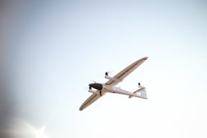
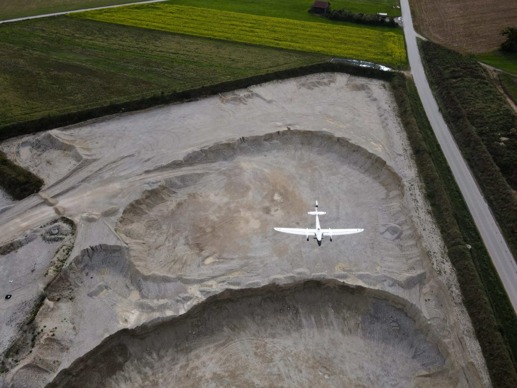
Quantum-Systems’ work with Wilderness International showcases precisely how important this technology is in protecting wildlife. Tasked with mapping tropical rainforests in Peru, Quantum Systems used its Trinity F90+ drone carrying either the RX1 or UMC, Sony RGB camera.

drones and high resolution lenses

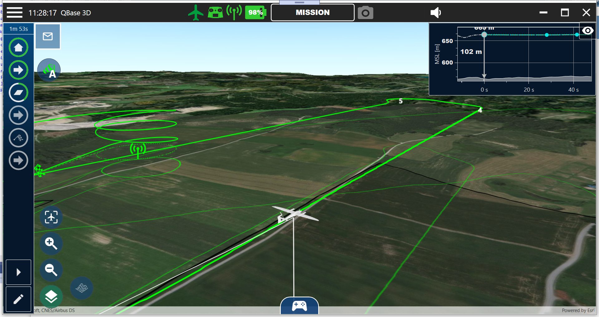
Offering up to 42MP and achieving 5304 x 7952 pixels with a full-frame image sensor, the cameras, used alongside a 35mm lens, can capture 102m by 68m areas with centimetre ground resolution in just one image. The pictures are taken with an 80% overlap, and then post-flight photogrammetry creates a georeferenced ‘map’ of the protected site.

The image quality and skill of the drones allow Wilderness International to monitor five million square meters of endangered rainforest. So, without being present in every location at all times, through ground-resolution mapping, the team can still detect changes in the environment as though they were on site.

Wilderness International also uses the images captured to track which area is protected by which donation, creating a personable experience in which donors can see the real impact of the project.

With flights scheduled every two to three years, organisations can use comparative images to observe changes, such as areas of illegal deforestation and natural occurrences like the migration of a river. By sharing the data with local scientists and charities, the health of plants and wildlife can be further analysed by the correct expert – ultimately, safeguarding not just the protected area but also the future health of our planet.

Read more about drones for conservation and wildlife protection:

  • From Drone Light Shows to Environmental Conservation: UgCS Drone Fleet Software Helps Scientists Count Penguin Chicks
  • Drones, Thermal Images and Koala Conservation
  • Drones for Environmental Protection: Oceans Unmanned and The Ocean Cleanup Join Forces
  • Drones for the Environment: Battling Trash in San Francisco Estuaries
  • World Oceans Day: Developing Drone Technology to Protect Marine Wildlife

Yasuo Baba has over 20 years of experience in the digital imaging industry. He has been responsible for Sony Digital Imaging Business Solutions in Europe since 2018.

In 2018, Baba-San was appointed as Director of Marketing at Sony Digital Imaging Business Solutions. His aim is to grow the business and increase market share by focusing on professional photography and to establish Sony as the photographic brand of choice among professionals.


Miriam McNabb

Miriam McNabb is the Editor-in-Chief of DRONELIFE and CEO of JobForDrones, a professional drone services marketplace, and a fascinated observer of the emerging drone industry and the regulatory environment for drones. Miriam has penned over 3,000 articles focused on the commercial drone space and is an international speaker and recognized figure in the industry.  Miriam has a degree from the University of Chicago and over 20 years of experience in high tech sales and marketing for new technologies.
For drone industry consulting or writing, Email Miriam.

TWITTER:@spaldingbarker

Subscribe to DroneLife here.

Filed Under: DL Exclusive, Drone News, Drone News Feeds, Featured, Imaging, News, Products, Selected - Products, Sensors Tagged With: drone imaging, drones for agriculture, drones for conservation, LIDAR, Lidar drone applications, Quantum-Systems, Sony, wildlife international

Reader Interactions

Trackbacks

  1. Drones and High Resolution Lenses Protect Wildlife says:
    June 12, 2022 at 1:41 am

    […] More… […]

    Reply
  2. Drones and High Resolution Lenses Protect Wildlife Around the World: Quantum Systems and Wilderness International in Peru - DroneLife - Wisata Bukit Lawang says:
    June 9, 2022 at 1:34 am

    […] source […]

    Reply
  3. Drones and High Resolution Lenses Protect Wildlife Around the World: Quantum Systems and Wilderness International in Peru – DroneLife says:
    June 8, 2022 at 9:50 pm

    […] source […]

    Reply
  4. Drones and High Resolution Lenses Protect Wildlife – my web says:
    June 8, 2022 at 3:32 pm

    […] Miriam McNabb is the Editor-in-Chief of DRONELIFE and CEO of JobForDrones, a professional drone services marketplace, and a fascinated observer of the emerging drone industry and the regulatory environment for drones. Miriam has penned over 3,000 articles focused on the commercial drone space and is an international speaker and recognized figure in the industry.  Miriam has a degree from the University of Chicago and over 20 years of experience in high tech sales and marketing for new technologies.For drone industry consulting or writing, Email Miriam. […]

    Reply
  5. Drones and High Resolution Lenses Protect Wildlife Around the World: Quantum Systems and Wilderness International in Peru | taktik(z) GDI (Government Defense Infrastructure) says:
    June 8, 2022 at 2:51 pm

    […] post Drones and High Resolution Lenses Protect Wildlife Around the World: Quantum Systems and Wilderness … appeared first on […]

    Reply
  6. Drones and High Resolution Lenses Protect Wildlife – Game Up News says:
    June 8, 2022 at 10:52 am

    […] Source link […]

    Reply

Leave a Reply Cancel reply

Your email address will not be published. Required fields are marked *

Primary Sidebar

LATEST

Walmart and Wing Launch Major Drone Delivery Expansion from Houston

By Dronelife Features Editor Jim Magill Eighteen lightweight UAVs sit on takeoff pads in the parking lot of a Walmart…

Continue Reading Walmart and Wing Launch Major Drone Delivery Expansion from Houston

Windracers ULTRA Achieves 2,000km Range with Heavy-Lift Payload Capability

British drone manufacturer Windracers has announced that its ULTRA heavy-lift drone can now fly up to 2,000km in a single…

Continue Reading Windracers ULTRA Achieves 2,000km Range with Heavy-Lift Payload Capability

NPSA Launches 2026 Counter-UAS Equipment Evaluations for UK Manufacturers

The National Protective Security Authority (NPSA) has opened expressions of interest for manufacturers and suppliers to participate in its independent…

Continue Reading NPSA Launches 2026 Counter-UAS Equipment Evaluations for UK Manufacturers

ISight Drone Services Achieves Statewide BVLOS Authorization for Vantis System in North Dakota

ISight Drone Services has received FAA approval to conduct beyond-visual-line-of-sight (BVLOS) operations across all four operational volumes of Vantis, North…

Continue Reading ISight Drone Services Achieves Statewide BVLOS Authorization for Vantis System in North Dakota

Unifly Completes FAA-Led Detect-and-Avoid Safety Standards Project

Terra Drone’s subsidiary Unifly has completed validation of “Well Clear Requirements” for drone Detect-and-Avoid (DAA) systems under the FAA’s ASSURE…

Continue Reading Unifly Completes FAA-Led Detect-and-Avoid Safety Standards Project

Meteodrones Provide New Data to National Weather Service

Switzerland-based meteorology data company Meteomatics has announced a partnership with NOAA’s National Mesonet Program (NMP) to integrate operational weather drone…

Continue Reading Meteodrones Provide New Data to National Weather Service

AURA Network Systems Conducts BVLOS Communications Tests

In collaboration with the Northern Plains UAS Test Site (NPUASTS) and the Federal Aviation Administration (FAA), AURA Network Systems has…

Continue Reading AURA Network Systems Conducts BVLOS Communications Tests

JIATF Awards First Replicator 2 Contract for C-UAS System

The Joint Interagency Task Force 401 (JIATF 401) has awarded its first contract under the Replicator 2 initiative, procuring two…

Continue Reading JIATF Awards First Replicator 2 Contract for C-UAS System

FAA Adds Two New UAS Test Sites to Advance Drone Integration

The U.S. Department of Transportation and the Federal Aviation Administration have announced two new UAS Test Sites in partnership with…

Continue Reading FAA Adds Two New UAS Test Sites to Advance Drone Integration

Kansas, Missouri Funding Counter-UAS at World Cup Events

By Dronelife Features Editor Jim Magill (Editor’s note: This is the second in a series of stories on efforts to…

Continue Reading Kansas, Missouri Funding Counter-UAS at World Cup Events

Secondary Sidebar

Footer

SPONSORED

Inspired Flight Gremsy IF800 VIO F1 drones geo week

What Will It Take to Strengthen U.S. Drone Manufacturing? A Conversation with Inspired Flight’s CEO

Global Mapper Mobile data collection

Collection Ground Control Points with Global Mapper Mobile

Military Drone Mapping Solutions

How SimActive’s Correlator3D™ is Revolutionizing Military Mapping: An Exclusive Interview with CEO Philippe Simard

Photogrammetry Accuracy Standards

SimActive Photogrammetry Software: Enabling Users to Meet Accuracy Standards for Over 20 Years

NACT Engineering Parrot ANAFI tether indoor shot

Smart Tether for Parrot ANAFI USA from NACT Engineering

Blue Marble, features global mapper, features Blue Marble

Check Out These New Features in Global Mapper v25 from Blue Marble

About Us | Contact Us | Advertise With Us | Write for Us | Privacy Policy | Terms of Service

The Trusted Source for the Business of Drones.

This website uses cookies and third party services. By clicking OK, you are agreeing to our privacy policy. ACCEPT

Manage consent

Privacy Overview

This website uses cookies to improve your experience while you navigate through the website. Out of these, the cookies that are categorized as necessary are stored on your browser as they are essential for the working of basic functionalities of the website. We also use third-party cookies that help us analyze and understand how you use this website. These cookies will be stored in your browser only with your consent. You also have the option to opt-out of these cookies. But opting out of some of these cookies may affect your browsing experience.
Necessary
Always Enabled
Necessary cookies are absolutely essential for the website to function properly. These cookies ensure basic functionalities and security features of the website, anonymously.
CookieDurationDescription
cookielawinfo-checkbox-analytics11 monthsThis cookie is set by GDPR Cookie Consent plugin. The cookie is used to store the user consent for the cookies in the category "Analytics".
cookielawinfo-checkbox-functional11 monthsThe cookie is set by GDPR cookie consent to record the user consent for the cookies in the category "Functional".
cookielawinfo-checkbox-necessary11 monthsThis cookie is set by GDPR Cookie Consent plugin. The cookies is used to store the user consent for the cookies in the category "Necessary".
cookielawinfo-checkbox-others11 monthsThis cookie is set by GDPR Cookie Consent plugin. The cookie is used to store the user consent for the cookies in the category "Other.
cookielawinfo-checkbox-performance11 monthsThis cookie is set by GDPR Cookie Consent plugin. The cookie is used to store the user consent for the cookies in the category "Performance".
viewed_cookie_policy11 monthsThe cookie is set by the GDPR Cookie Consent plugin and is used to store whether or not user has consented to the use of cookies. It does not store any personal data.
Functional
Functional cookies help to perform certain functionalities like sharing the content of the website on social media platforms, collect feedbacks, and other third-party features.
Performance
Performance cookies are used to understand and analyze the key performance indexes of the website which helps in delivering a better user experience for the visitors.
Analytics
Analytical cookies are used to understand how visitors interact with the website. These cookies help provide information on metrics the number of visitors, bounce rate, traffic source, etc.
Advertisement
Advertisement cookies are used to provide visitors with relevant ads and marketing campaigns. These cookies track visitors across websites and collect information to provide customized ads.
Others
Other uncategorized cookies are those that are being analyzed and have not been classified into a category as yet.
SAVE & ACCEPT