
• Skip to main content
  • Skip to secondary menu
  • Skip to primary sidebar
  • Skip to secondary sidebar
  • Skip to footer
  • DroneRacingLife
  • DroneFlyers
  • Newsletter
DroneLife

DRONELIFE

Stay up to date on all the latest Drone News

  • News
  • Products
  • Industries
    • Agriculture
    • Construction
    • Delivery
    • Dual Use
    • Inspection
    • Public Safety
    • Surveying
  • Enthusiasts
  • Regulations
  • Business
  • Video
  • Podcasts

DroneSense: Teaming Up with Texas Law Enforcement

March 17, 2021 by staff 11 Comments

DroneSenseTexas law teams up with Austin-based drone software company
By DRONELIFE Staff Writer Jim Magill

Picture a search and rescue mission in which a hiker is lost in a remote brush-covered region of West Texas. The state’s premier law enforcement agency, the Department of Public Safety, launches several drones to conduct the search, as does the local sheriff’s department.

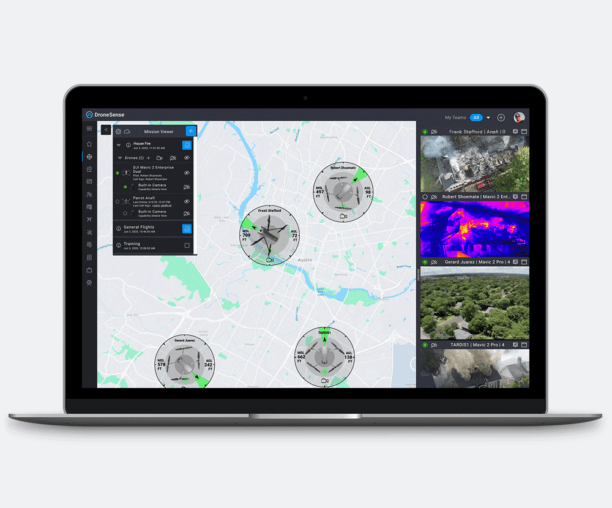
An application provided by Austin-based drone software developer DroneSense is helping incident commanders on the ground to coordinate the flight of the multiple unmanned aerial vehicles, and providing greater situational awareness of the entire scene.

On Tuesday the company announced that DPS had awarded DroneSense a multi-year contract to provide the agency the tools “to improve situational awareness by centralizing and integrating massive data sets, and creating the ideal environment for multiple agencies to collaborate and work together effectively to face any public safety crisis.”

The DroneSense platform allows drone “pilots, operators and administrators to communicate easily and effectively with one another and share mission-critical information.” The software is hardware-agnostic, meaning it can be used by agencies operating drones produced by multiple manufacturers, including DJI, Parrot and Autel. It can also be run on both iOS and Android phones and tablets.

“There’s an entire collaboration piece that allows pilots to collaborate in real time, not only from one agency, but they can connect with multiple agencies on the same scene and they can be sharing video and telemetry and geospatial information,” DroneSense CEO Chris Eyhorn said in an interview.

Eyhorn said the software provider has had a “laser-beam focus on public safety” since its founding in 2015. “We believe the use of drones in their space can fundamentally change how fire service, police agencies and emergency management services do their jobs,” he said.

The DPS, which has a fleet of more than 100 small unmanned aerial vehicles, uses drones across its broad range of missions including: law enforcement, counterterrorism, disaster response and search and rescue. The agency also offers drone operation training at its facility in Florence, Texas, where UAS operators from agencies across the state and country are trained in real-world situations including night operations, search and rescue and clearing buildings.

DPS “has really been a leader in the public safety space,” Eyhorn said. The agency is at the forefront of adopting and operationalizing the drone-related technology.

Contract continues existing cooperation

The agreement announced this week continues an existing relationship between DPS and DroneSense.

“The contract allows us to more quickly add more drones and more products to the platform,” Eyhorn said. “For us as a company, the contract is also an endorsement of the value that we’re bringing them and the value that they’re able to show the state of Texas in having a large program like this.”

In order to ensure its applications can run in conjunction with drones produced by different manufacturers, DroneSense’s software implements each manufacturers’ software development kit (SDK).

“We translate that into our own DroneSense SDK,” Eyhorn said. “The rest of the platform and every other feature is built on top of our SDK. When we have a new drone from a manufacturer that we’d like to support, all we have to do is translate its software development kit into the DroneSense SDK and then all of a sudden, it fully participates in the rest of the ecosystem.”

In its contract with DPS, the agency deploys the DroneSense software to increase its situational awareness in a number of different kinds of operations where drones are deployed: search and rescue, overwatch of a SWAT raid, or apprehending fleeing suspects.

“During a disaster response, everybody’s running DroneSense. If they have multiple drones up, it allows them to geospatially see where all the drones are but more importantly, to see where they have been,” he said. The software allows incident commanders on the ground to tie together into a single picture the flight paths flown by all the drones involved in the operation during a given period of time.

“It makes multi-drone operations very seamless, where without a tool like this, it becomes very complex,” Eyhorn said. “The commanders are able to get a clear picture of where they’ve flown and where they haven’t.”

Software aids in search operations

In the case of a search and rescue operation in which a hiker calls 9-1-1 after falling and breaking his leg, the dispatcher gives the drone pilot the correct latitude/longitude position and the pilot can quickly punch the data into the application, marking the location of the incident.

“That marker will be shared with all the other pilots in the ops center and they can click a button and [the drone] will fly autonomously to that maker and they can have real-time video feed and help guide the rescue teams,” Eyhorn said.

DroneSense recently released a mobile streaming and tracking app, which can run on mobile devices, allowing searchers on the ground – even four-footed ones – to transmit video and be tracked in real time in the same way the aerial vehicles are.

“We can now bring in non-drone assets and be able to livestream the video from those devices all into the back end,” Eyhorn said.

Using this app, searchers can strap a cell phone onto the neck of a search and rescue dog and let the dog loose to find the injured party. “The pilot can see exactly where the dog is and can fly the drone to follow it.”


Filed Under: Drone News Feeds, News Tagged With: DPS, Drone Software, drones for law enforcement, dronesense

Reader Interactions

Trackbacks

  1. Austin PD Drones: Department to Launch Robotics Unit | taktik(z) GDI (Government Defense Infrastructure) says:
    September 27, 2021 at 5:22 pm

    […] its drone-collected data, the department employs the DroneSense software platform, which offers a Department of Defense-rated encrypted network, not accessible to unauthorized persons. The software tracks and records every drone flight, which […]

    Reply
  2. DroneSense: Teaming Up with Texas Law Enforcement - DronesOnline.site says:
    March 21, 2021 at 12:50 am

    […] post DroneSense: Teaming Up with Texas Law Enforcement appeared first on […]

    Reply
  3. DroneSense is Helping TX Law Enforcement - Go Drones Blog says:
    March 17, 2021 at 6:10 pm

    […] DroneSense, a Texas-based drone software company, helps the Department of Public Safety to bring drone capabilities into the field. Source […]

    Reply
  4. DroneSense is Helping TX Law Enforcement - kameratalk.com says:
    March 17, 2021 at 3:51 pm

    […] Source link […]

    Reply
  5. DroneSense is Helping TX Law Enforcement | Aerial Division says:
    March 17, 2021 at 1:08 pm

    […] Source link […]

    Reply
  6. DroneSense is Helping TX Law Enforcement – Game of Drones says:
    March 17, 2021 at 10:37 am

    […] Article Source […]

    Reply
  7. DroneSense is Helping TX Law Enforcement – Dronestagram Blog says:
    March 17, 2021 at 10:19 am

    […] More… […]

    Reply
  8. DroneSense: Teaming Up with Texas Law Enforcement – Drones Crunch says:
    March 17, 2021 at 9:40 am

    […] DRONELIFE […]

    Reply
  9. DroneSense: Teaming Up with Texas Law Enforcement – DronePilots.News says:
    March 17, 2021 at 9:26 am

    […] Source […]

    Reply
  10. DroneSense is Helping TX Law Enforcement – Drone Observer says:
    March 17, 2021 at 9:25 am

    […] Source link […]

    Reply
  11. DroneSense: Teaming Up with Texas Law Enforcement | Drone Magazine says:
    March 17, 2021 at 9:00 am

    […] Source […]

    Reply

Leave a Reply Cancel reply

Your email address will not be published. Required fields are marked *

Primary Sidebar

LATEST

FCC Expands Conditional Approvals for Foreign-Made Drone Systems

Blueflite, Verity, and Air VEV Added to Growing List of Exempted Aircraft Under FCC Covered List Rules The Federal Communications…

Continue Reading FCC Expands Conditional Approvals for Foreign-Made Drone Systems

Public Safety Drone Review June 2, 2026: Michelle Duquette of 3 MAD Air on the Future of Integrated Airspace

Join us Tuesday, June 2 at 3pm EST for the next edition of the Public Safety Drone Review, presented by…

Continue Reading Public Safety Drone Review June 2, 2026: Michelle Duquette of 3 MAD Air on the Future of Integrated Airspace

A2Z Drone Delivery Joins Kazakhstan’s Alatau City Urban Air Mobility Project

The Torrance, California drone maker partners with Alatau Advance Air Group on next-generation drone infrastructure at the new UAM Test…

Continue Reading A2Z Drone Delivery Joins Kazakhstan’s Alatau City Urban Air Mobility Project

Texas DPS Launches Counter-UAS Strategy for World Cup

By Dronelife Features Editor Jim Magill Texas DPS deploys counter-drone tech for World Cup. (Editor’s note: This story is part…

Continue Reading Texas DPS Launches Counter-UAS Strategy for World Cup

Smart Materials and the Rise of Ornithopters: on this episode of the Drone Radio Show!

Dr. Onur Bilgen,  Associate Professor in the Department of Mechanical and Aerospace Engineering at Rutgers University. talks about the future…

Continue Reading Smart Materials and the Rise of Ornithopters: on this episode of the Drone Radio Show!

NOAA Sends Autonomous Surface Vehicles Into Hurricanes to Study Rapid Intensification

Long-running partnership with Saildrone aims to improve hurricane forecasting and rapid intensification models Saildrone announced plans to deploy 10 Saildrone…

Continue Reading NOAA Sends Autonomous Surface Vehicles Into Hurricanes to Study Rapid Intensification

If Pilots Stop Trusting Safety Broadcasts, What Happens to Universal Conspicuity?

AOPA’s opposition to ADS-B billing highlights a growing issue for both crewed and uncrewed aviation News and Commentary. A new…

Continue Reading If Pilots Stop Trusting Safety Broadcasts, What Happens to Universal Conspicuity?

The Drone Industry’s Battery Problem Has a New Challenger

Factorial Expands Solid-State Drone Battery Partnerships Across Three Continents New collaborations aim to improve drone endurance, power, and cold-weather performance…

Continue Reading The Drone Industry’s Battery Problem Has a New Challenger

Commercial UAV Expo Releases 2026 Conference Program Focused on “Actionable Insights”

Community feedback shapes event agenda centered on real-world drone operations and practical takeaways Commercial UAV Expo has announced its 2026…

Continue Reading Commercial UAV Expo Releases 2026 Conference Program Focused on “Actionable Insights”

US Drone Makers Are Building a Different Kind of Factory

Additive Manufacturing Helps Build Flexibility, Scale, and Supply Chain Resilience At AUVSI’s XPONENTIAL 2026 conference in Detroit, one theme surfaced…

Continue Reading US Drone Makers Are Building a Different Kind of Factory

Secondary Sidebar

Footer

SPONSORED

Inspired Flight Gremsy IF800 VIO F1 drones geo week

What Will It Take to Strengthen U.S. Drone Manufacturing? A Conversation with Inspired Flight’s CEO

Global Mapper Mobile data collection

Collection Ground Control Points with Global Mapper Mobile

Military Drone Mapping Solutions

How SimActive’s Correlator3D™ is Revolutionizing Military Mapping: An Exclusive Interview with CEO Philippe Simard

Photogrammetry Accuracy Standards

SimActive Photogrammetry Software: Enabling Users to Meet Accuracy Standards for Over 20 Years

NACT Engineering Parrot ANAFI tether indoor shot

Smart Tether for Parrot ANAFI USA from NACT Engineering

Blue Marble, features global mapper, features Blue Marble

Check Out These New Features in Global Mapper v25 from Blue Marble

About Us | Contact Us | Advertise With Us | Write for Us | Privacy Policy | Terms of Service

The Trusted Source for the Business of Drones.

This website uses cookies and third party services. By clicking OK, you are agreeing to our privacy policy. ACCEPT

Manage consent

Privacy Overview

This website uses cookies to improve your experience while you navigate through the website. Out of these, the cookies that are categorized as necessary are stored on your browser as they are essential for the working of basic functionalities of the website. We also use third-party cookies that help us analyze and understand how you use this website. These cookies will be stored in your browser only with your consent. You also have the option to opt-out of these cookies. But opting out of some of these cookies may affect your browsing experience.
Necessary
Always Enabled
Necessary cookies are absolutely essential for the website to function properly. These cookies ensure basic functionalities and security features of the website, anonymously.
CookieDurationDescription
cookielawinfo-checkbox-analytics11 monthsThis cookie is set by GDPR Cookie Consent plugin. The cookie is used to store the user consent for the cookies in the category "Analytics".
cookielawinfo-checkbox-functional11 monthsThe cookie is set by GDPR cookie consent to record the user consent for the cookies in the category "Functional".
cookielawinfo-checkbox-necessary11 monthsThis cookie is set by GDPR Cookie Consent plugin. The cookies is used to store the user consent for the cookies in the category "Necessary".
cookielawinfo-checkbox-others11 monthsThis cookie is set by GDPR Cookie Consent plugin. The cookie is used to store the user consent for the cookies in the category "Other.
cookielawinfo-checkbox-performance11 monthsThis cookie is set by GDPR Cookie Consent plugin. The cookie is used to store the user consent for the cookies in the category "Performance".
viewed_cookie_policy11 monthsThe cookie is set by the GDPR Cookie Consent plugin and is used to store whether or not user has consented to the use of cookies. It does not store any personal data.
Functional
Functional cookies help to perform certain functionalities like sharing the content of the website on social media platforms, collect feedbacks, and other third-party features.
Performance
Performance cookies are used to understand and analyze the key performance indexes of the website which helps in delivering a better user experience for the visitors.
Analytics
Analytical cookies are used to understand how visitors interact with the website. These cookies help provide information on metrics the number of visitors, bounce rate, traffic source, etc.
Advertisement
Advertisement cookies are used to provide visitors with relevant ads and marketing campaigns. These cookies track visitors across websites and collect information to provide customized ads.
Others
Other uncategorized cookies are those that are being analyzed and have not been classified into a category as yet.
SAVE & ACCEPT



