 The following is press release from PrecisionHawk.
PrecisionHawk’s Low Altitude Traffic and Airspace Safety (LATAS) platform to replace AirMap
PrecisionHawk, Inc. today announced a partnership with DJI, the world’s leader in civilian drones and aerial imaging technology, to improve its geofencing technology. Leveraging PrecisionHawk’s Low Altitude Traffic and Airspace Safety (LATAS) platform, DJI will be able to refine airspace limitations for drone flights near airports in order to provide smarter protection for drones in critical areas and clarify restrictions.
This partnership will go into effect as DJI releases its Geospatial Environment Online (GEO) Version 2.0. To obtain reliable geospatial information for the enhanced shapes in GEO 2.0, DJI will use data from PrecisionHawk’s LATAS platform, replacing DJI’s previous geospatial data provider AirMap. LATAS will provide DJI’s customers with critical airspace information that will position them to fly safely in North America.
“PrecisionHawk has an unwavering commitment to safely integrating drones into the airspace and enabling complex operations. Through our work under the FAA Pathfinder Program, we have shown how technology such as LATAS can play a critical role in unlocking advanced operations, including beyond visual line of sight flight,” said Diana Cooper, senior vice president of policy and strategy at PrecisionHawk. “After years of development and testing, we are excited to leverage our LATAS platform to support DJI’s customers in conducting safe drone operations across North America.”
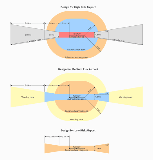
LATAS data supports detailed three-dimensional “bow tie” safety zones surrounding runway flight paths and uses complex polygon shapes around other sensitive facilities, rather than just simple circles. These new restrictions better reflect the actual safety risk posed in those areas, while allowing more flights to the side of runways where risk is substantially lower.

“DJI is pleased to partner with companies that support our vision of safe skies that are open to innovation,” said Brendan Schulman, DJI vice president of policy & legal affairs. “DJI pioneered geofencing for drones, as well as automatic altitude limitations, collision avoidance sensors and a mandatory knowledge quiz about safe flight rules. PrecisionHawk shares DJI’s commitment to ensuring that safety technology enhances the ability of recreational and commercial drone pilots to fly.”
Assistive technology plays a critical role in supporting operators as they comply with safety standards. LATAS, which was tested under the FAA Pathfinder Program to facilitate safe beyond visual line of sight operations, brings a combined set of geospatial and software tools to the market. In addition to providing improved geospatial data, the LATAS platform features specialized display elements, including telemetry and access to the Harris real-time manned aircraft feed. Using these elements pilots can easily observe the relative altitude and horizontal separation of intruding aircraft and other mission-critical measures.
The updated GEO Version 2.0 will be phased in starting later this month, when the revised zones will take effect for airspace around airports in the United States.


[…] The following is press release from PrecisionHawk. PrecisionHawk’s Low Altitude Traffic and Airspace Safety (LATAS) platform to replace AirMap PrecisionHawk, Inc. today announced a partnership with DJI, the world’s leader in civilian drones and aerial imaging technology, to improve its geofencing technology. Leveraging PrecisionHawk’s Low Altitude Traffic and Airspace Safety (LATAS) platform, DJI will be […] The post PrecisionHawk Announces DJI Partnership appeared first on DRONELIFE. <bSee Original Article […]