Parrot, the UAV technology firm, has announced two new drones that broaden its enterprise offerings. The new UAVs, the Parrot Bluegrass and the Parrot Bebop-Pro Thermal, are aimed at the commercial agriculture, construction and public safety markets.
It’s a strong signal from a firm that is clearly looking to stay competitive with DJI by offering a full suite of drone offerings that run the gamut from consumer to prosumer to enterprise markets. As Chris Roberts, Global Chief Marketing Officer for Parrot said in a call with DroneLife:
[quote]
“These drones provide a bridge between our BeBop and Dicco Pro. Parrot is always pushing boundaries of innovation. With the Bebop Pro-thermal and Bluegrass we continue our focus on vertical real time solutions, These new drones are dedicated to three verticals: agriculture, construction, and public safety.”
[/quote]
They also round out Parrot’s existing portfolio which includes the Sensefly fixed wing UAV and Pix4D the imaging firm.
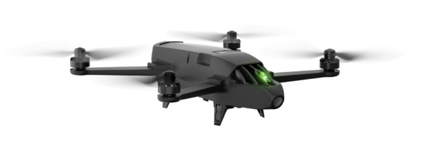
The Parrot Bluegrass
 Priced at $5,000, the Bluegrass is the first Parrot quadcopter specifically targeted for agriculture. With the launch of Parrot Bluegrass, Parrot upping its commitment to providing solutions for business, with UAV’s, sensors and software.
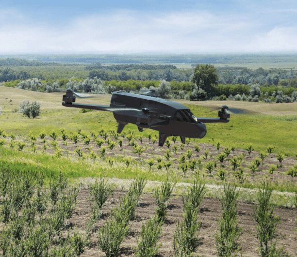
The Bluegrass is a multipurpose quadcopter designed for agriculture that uses 2 embedded cameras; video camera and multispectral sensor. Its front full HD video camera helps farmers visually monitor a farm’s infrastructure, the land and herds. It also enables farmers to obtain an overview and detect problem areas in all types of crop fields, thanks to its multispectral sensor.
The drone can cover up to 30 hectares at 70 m / 230 ft. flight altitude per battery and fly at low altitudes optimizing scouting fruit crops that require more mapping precision. It weighs 1.9 kg and is equipped with an on-board computing system, as well as embedding the Parrot Sequoia, an advanced multispectral sensor.
Parrot Bluegrass Agricultural Solution includes:
- A powerful and easy to handle quadcopter equipped with a full HD front camera & embedded Parrot Sequoia advanced multispectral sensor.
- Flight planning mobile application with Pix4Dcapture
- Data processing with AIRINOV FIRST+ cloud platform
- A long range remote control Parrot Skycontroller 2
Pix4Dcapture is a planning app that enables farmers to precisely define the specific plot they want to map. The user adapts the flight parameters according to the precision needed and the type of crops. The entire flight, from take-off to landing, is done autonomously by the quadcopter and the images captured by frontal Full HD 14MP camera are streamed live on the tablet’s screen.
The Bluegrass can also be piloted manually using the included Parrot Skycontroller 2 Wi-Fi remote control, which provides a 2km range, with the capability to statically hover and inspect.
The Parrot Sequoia which is included is a multispectral sensor with GPS that automatically records images of crops in four distinct spectral bands: green (500nm Bandwidth 40nm), red (660nm Bandwidth 40nm), red-Edge (735nm Bandwidth 10nm) and near Infrared (790nm Bandwidth 40nm). It is equipped with a RGB camera (16 MP); a 64GB internal memory to store captured images and a luminosity sensor (‘sunshine’ sensor) that records lighting conditions and automatically calibrates collected data with the multispectral sensor data during the computer processing phase.
Data analytics is handled by Parrot’s AIRINOV FIRST+, the mapping and analysing platform for multispectral images captured by Parrot Sequoia.
With the Bluegrass a farmer receives a turnkey report composed of orthomosaic NDVI maps (absolute and adjusted) and zoning (simple and detailed). This provides a precise view of the biomass (density of vegetation) and relative health of the crops, helping professionals to determine which areas need specific attention. Professionals can use these insights to inform corrective actions and track the effects and evolution of the farm with high precision.
The Parrot Bluegrass will be available during November 2017 at drone resellers, general farming outlets, agricultural tech specialists’ and www.parrot.com.
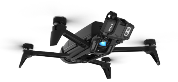
The Parrot Bebop-Pro THERMAL
The Parrot Bebop-Pro Thermal expands the Parrot Professional range of business solutions launched earlier this year with Parrot Disco-Pro AG & Parrot Bebop Pro-3D Modeling, and Parrot Bluegrass.
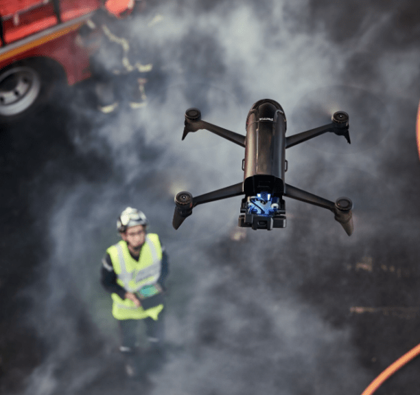
It is an all-in-one quadcopter thermal imaging solution designed for small construction businesses, thermal inspection professionals and public safety services; enabling them to safely carry out inspections with its 2 embedded cameras: video camera and thermal imaging camera.
With its front full HD video camera this solution helps the construction user or rescue service to visually monitor a structure or a specific area, while the thermal camera enables to get precise and detailed thermal images thanks to the dedicated FreeFlight Thermal app.
he compact drone is has a compact form factor and is designed to be user friendly, easy to set up, easy to fly and easy to repair. Users can live stream or record videos and take pictures of buildings, roofs, solar panels or specific areas in visual or thermal image mode.
The Bebop-Pro Thermal solution includes:
- A compact quadcopter with a Full HD stabilized front facing camera, a FLIR ONE® Pro thermal camera and a 32Gb memory
- Parrot FreeFlight Thermal app, which innovatively transmits and analyses images captured by the quadcopter’s cameras
- A long range remote control Parrot Skycontroller 2
Parrot Bebop-Pro Thermal is based on the Parrot Bebop 2 Power quadcopter, which has been modified to benefit professionals. Images are captured by the Parrot Bebop-Pro’s Full HD 14MP front camera and the thermal camera positioned in a dedicated module at the back of the drone.
The FreeFlight Thermal app streams images from both cameras (front and thermal) directly to a connected tablet. At any time during flight, the pilot can switch from a thermal image to a HD image, record video footage, and store captured content to the drone’s 32GB memory.
The thermal camera is lightweight (36.5 gr) and comes equipped with two sensors: a RGB sensor (1440x1080p), capturing what the drone can visibly see, and a thermal sensor (160x120p), which measures temperature differences.
Data from both sensors are combined by the FreeFlight Thermal app to create precise and detailed images. Edge surrounding details are highlighted in the image, areas with thermal loose or hot spots can be immediately identified. Touching one part of the connected tablet’s screen will show the estimated thermal temperature captured by the sensors.
There are 3 imaging thermal setting modes* available:
- Standard: Thermal images, from red (160°) to blue (10°) scale are displayed, for quick identification of thermal losses.
- Dynamic: The thermal color scale is adapted to the ambient temperature. This allows the user to benefit from an accurate view of the thermal losses. High temperatures are highlighted in red, and cooler temperatures are displayed in blue.
- Hotspot: This mode is adapted for fire safety professionals and emergency search and rescue specialists. Only the highest temperatures recorded are highlighted and combined with the RGB image.
*Users can play video recorded using another color scale setting and export them in a standard video format
The HD 14MPx front facing stabilised camera of the Parrot Bebop-Pro Thermal enables a visual inspection of a building, and enables the pilot to obtain videos and pictures to understand the condition of a building. Files can be saved and used to provide evidence of a building’s damage and estimate costs.
Frank Schroth is editor in chief of DroneLife, the authoritative source for news and analysis on the drone industry: it’s people, products, trends, and events.
Email Frank
TWITTER:@fschroth


[…] mind. Parrot’s made some interesting moves in recent times. I had wrongly assumed that adapting the Bebop 2 and Disco drones for business use was a sign of things to come, that the company was moving the way of 3DR and shifting […]