 Skyguide, Switzerland’s air navigation service provider, and its project partners demonstrated today in Geneva how drones can be safely and efficiently integrated into the existing airspace. The partners say that the demonstration shows that drone integration is ready for deployment in Europe now.
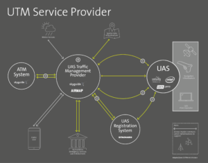
The group of partners included AirMap, SITAONAIR, SenseFly and PX4. The partners represent varying aspects of UTM technology, from operating platforms to drone manufacturers and drone autopilot systems. The project that they worked on is called U-Space: it’s the digital infrastructure, services, and procedures for drone integration into European airspace, a concept supported by the European Commission, SESAR, and EASA.
“The live demonstration of the so called U-space …proves that the air navigation services are ready for the next stage of drone integration,” says the company. “It could also open up the global market.”
The partners “performed three live missions flown by senseFly’s albris and eBee Plus drones and a drone with pre-programmed PX4 flight controller to demonstrate how drones can be easily announced to the air navigation service provider through e-registration and e-identification,” says the announcement. “The integration with air traffic control, flight planning and airspace authorization as well as live tracking/telemetry and dynamic situational awareness were also part of the live demonstration.”
The September 14th event was the region’s first real-time demonstration of U1 (e-registration, e-identification, and geofencing) and U2 (flight planning, flight approval, and dynamic airspace awareness) U-space capabilities – the first two of four planned milestones in the evolution of U-space.
While U1 capabilities are expected to be operational in 2019, the partners say that the demonstration proves that U1 and U2 services are ready to be deployed immediately.
 During the demonstration, the participants exhibited:
- Drone registration with a blockchain-based database managed by SITAONAIR
- Authentication of identifying information shared by senseFly by AirMap against the SITAONAIR registration database
- Integration with air traffic control & digital airspace approval from skyguide through the AirMap platform
- Flight planning and real-time drone telemetry data sent by senseFly drones, visualized on AirMap U-space dashboard, and displayed on senseFly’s ground control station
Representatives from the European aviation and drone community, the director of the Federal Office of Civil Aviation, Christian Hegner, and representatives from Geneva State Council for Security and Economy attended the demonstration.
“We see ourselves as an enabler to the drone industry. The U-space can only develop successfully if the different players collaborate efficiently together and embrace innovation. The demonstrator shows that this is possible. I look forward to us taking the next steps together with our partners as soon as possible.” said Alex Bristol, CEO of skyguide.
“This is an important step forward for the entire drone ecosystem, in Europe and beyond,” said Ben Marcus, CEO of AirMap. “U-space will make it possible for millions of drones and countless commercial drone enterprises to take flight in European skies. We’re proud to help pave the way for U-space with skyguide, SITAONAIR, senseFly, and PX4 – part of our worldwide efforts to open more airspace for drones.”

Miriam McNabb is the Editor-in-Chief of DRONELIFE and CEO of JobForDrones, a professional drone services marketplace, and a fascinated observer of the emerging drone industry and the regulatory environment for drones. Miriam has penned over 3,000 articles focused on the commercial drone space and is an international speaker and recognized figure in the industry. Miriam has a degree from the University of Chicago and over 20 years of experience in high tech sales and marketing for new technologies.
For drone industry consulting or writing, Email Miriam.
TWITTER:@spaldingbarker
Subscribe to DroneLife here.


[…] Source link […]