• Skip to main content
  • Skip to secondary menu
  • Skip to primary sidebar
  • Skip to secondary sidebar
  • Skip to footer
  • DroneRacingLife
  • DroneFlyers
  • Newsletter
DroneLife

DRONELIFE

Stay up to date on all the latest Drone News

  • News
  • Products
  • Industries
    • Agriculture
    • Construction
    • Delivery
    • Dual Use
    • Inspection
    • Public Safety
    • Surveying
  • Enthusiasts
  • Regulations
  • Business
  • Video
  • Podcasts

Where Can I Fly My Drone? These 5 Apps Will Help

March 14, 2017 by Malek Murison 6 Comments

Whatever country you’re based in, it’s likely that there are regulations in place surrounding recreational and commercial drone flights. Some are fairly common-sense, such as the need to avoid airports, prisons and military bases. Others are less clear cut, like national parks or what constitutes a ‘public event’. Either way, the responsible thing to do is check whether it’s safe and legal to fly before your drone leaves the ground.

This is especially the case if you’re flying for commercial reasons. Not only is your insurance likely to be void in the event of flying in a no-fly zone, but your license could be revoked and your source of income stripped away. Better safe than sorry.

Luckily, wherever you live and work there’s a good chance that a simple application on your smartphone can give you all the information you need to make an informed decision. Here’s our rundown of the apps you need so that you can fly your drone within the rules.

Handy drone apps available worldwide

UAV Forecast

UAV Forecast is a great app that pilots, whether professional or recreational, should add to their arsenal. Few ‘Where Can I fly?’ apps offer this level of coverage. As well as giving you up to date forecasts regarding weather and wind speed, UAV Forecast shows you real-time flight restrictions and clearly identifies no-fly zones  near your chosen location.
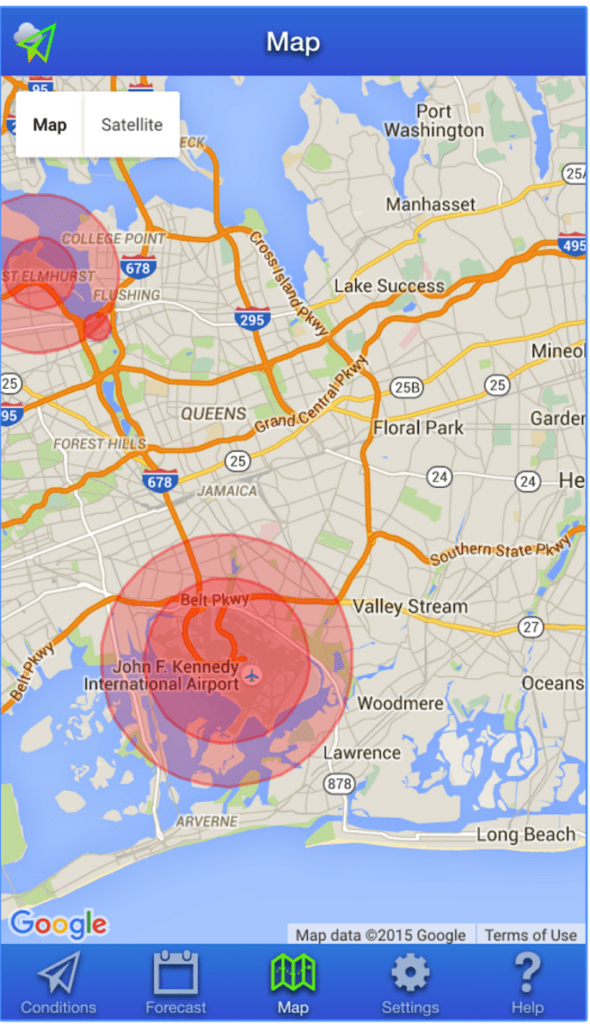
where can I fly apps drone
UAV Forecast

Price: Free

Available on: Andriod and iOS.

Hover

hover app for phantom
Hover

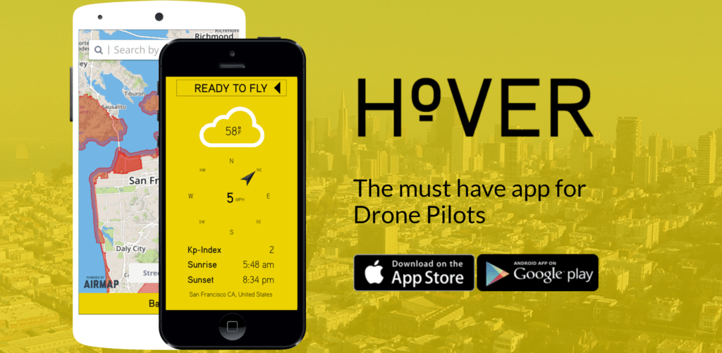
We’ve featured Hover several times in our ‘Top App‘ articles – and for good reason. The team at Hover has developed a drone app that’s easy to use and informative no matter what the purpose of your flight.

It’s also a lot more than just a map detailing no-fly zones. A few features of the Hover app include:

  • International No-fly Zone Maps provided by AirMap.io
  • An intuitive interface to help you navigate the skies safely
  • Current weather conditions and forecasts, with a detailed breakdown of wind speed and direction, rain or shine, and temperature
  • Flight Logs: Individuals and teams can seamlessly track, log, and maintain their drone fleet. Manage drones, equipment, and personnel
  • Flight Readiness Indicator: An easy to understand flight status to let you know if it’s safe to fly your drone depending on the location and conditions
  • News Feed, including coverage from DroneLife.com, helping pilots stay up to date with what’s going on in the drone industry

Price: Free

Available on: Android and iOS

USA Only

B4UFLY

The FAA’s B4UFLY app.

B4UFLY is the FAA’s own app designed to keep pilots and their drones operating within the law. Don’t expect any of the nice touches found in Hover of UAV Forecast – this is purely about keeping drone flyers up to date with legislation, helping them determine whether there are any restrictions or requirements in effect at the location where they want to fly.

Key features of the B4UFLY app include:

  • A clear “status” indicator that immediately informs the operator about the current or planned location. For example, it shows flying in the Special Flight Rules Area around Washington, D.C. is prohibited.
  • Information on the parameters that drive the status indicator
  • A “Planner Mode” for future flights in different locations
  • Informative, interactive maps with filtering options
  • Links to other FAA UAS resources and regulatory information

Price: Free

Available: App Store for iOS and Google Play store for Android.

AirMap

AirMap fly safely apps
AirMap

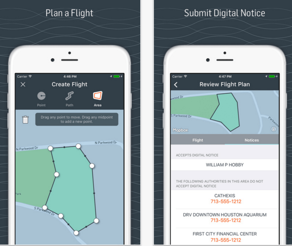
AirMap is the provider of airspace maps to the FAA’s Know Before You Fly Campaign. The AirMap app was released to make drone operations safer by connecting UAV pilots to airport operators and air traffic controllers.

As of last year, AirMap had 75 airports onboard with the application, providing airport managers with a dashboard from which they can grant permission for drone flights and set specific automated policies for certain areas near their airports.

Arguably more for commercial than recreational use, AirMap gives pilots a clear view of nearby aerospace information and allows them to report when and where they’re going to fly. That information is given to airports so that accidents can be avoided.

AirMap offers these features and more:

– View Airspace Data
– Toggle Airspace Information & Advisory Map Overlays
– Super Fast Vector Maps
– Pilot Profile View
– Manage UAV Aircraft
– Create & Manage Flights (incl. Future Flights)
– File Digital Flight Notifications (D-NAS)
– View Public Flights
– RealtimeReal-time Alerts
– Toggle between Four Different Map Styles
– Search Map by Place or Location

Price: Free

Available on: Android and iOS.

UK Only

Drone Assist

Drone Assist uk australia app
Drone Assist

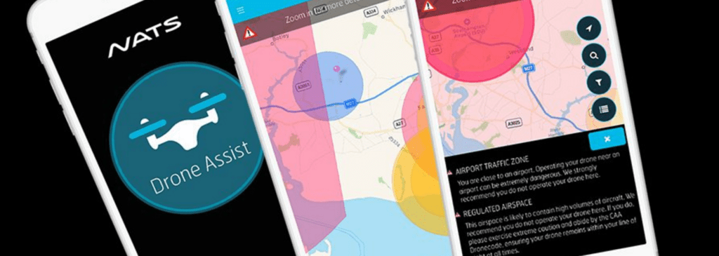
Since the UK’s Civil Aviation Authority teamed up with the National Air Traffic Control Services to launch Drone Assist, UK drone pilots have downloaded the app in their thousands.

The CAA app gives users access to an interactive map of UK airspace, which is also used and updated by commercial air traffic. This gives pilots warning of areas to avoid or in which extreme caution should be exercised, as well as ground hazards that may pose safety, security or privacy risks when you’re out flying your drone.

It also contains a ‘Fly Now’ feature that enables you to share your drone flight location with other app users and the wider drone community, helping to reduce the risk of a drone-related incident in UK’ airspace.

Price: Free

Available on: iOS and Android

Any ‘Where Can I Fly?’ apps that we’ve missed off our list? Let us know in the comments below.

Malek Murison
Malek Murison

Malek Murison is a freelance writer and editor with a passion for tech trends and innovation. He handles product reviews, major releases and keeps an eye on the enthusiast market for DroneLife.
Email Malek
Twitter:@malekmurison

Subscribe to DroneLife here.

Filed Under: Business and Finance, Drone News Feeds, Featured - Enthusiasts, Fire and Police, News Tagged With: best apps, CAA, FAA, hover, uav forecast, where can I fly

Reader Interactions

Trackbacks

  1. Which drone to buy? — Things to know before buying: Drones says:
    December 9, 2020 at 12:11 pm

    […] I recommend using AirMap or Hover as they are easy to understand and very user friendly. Check out this article by dronelife for a great run down on the different functionality between these […]

    Reply
  2. Dron para principiantes | beco says:
    November 11, 2020 at 1:16 pm

    […] sé consciente que hay espacios prohibidos para volarlo, respétalas. DJI las incluye en su app, pero hay más. […]

    Reply
  3. Pro Tips That Will Improve Your Drone Photography | Pixinfocus says:
    January 27, 2019 at 6:39 pm

    […] I live in Sydney, Australia and I know exactly where I can and cannot fly my drone. I know exactly what is the maximum altitude I can reach and the limitations I have. Every Country or City can have different rules. Do not break them. It’s not worth it trust me. First of all you can cause harm to yourself and other people, drones can disturb animals and it should be prohibited in National Parks (it is here in New South Wales).I use the official app released by the Australian Government. It tells you where you can fly and the rules for that area, it’s for Australia only and you can find it at this linkwww.casa.gov.auYou can find other useful apps and resources if you live outside Australia by searching on Google, but I found this list of apps posted on DroneLife. It’s good list and you can find it here: Where can I fly my drone apps […]

    Reply
  4. Dron para principiantes – beco says:
    August 5, 2018 at 1:52 pm

    […] sé consciente que hay espacios prohibidos para volarlo, respétalas. DJI las incluye en su app, pero hay más. […]

    Reply
  5. Dron para principiantes – b3co says:
    December 11, 2017 at 6:32 pm

    […] sé consciente que hay espacios prohibidos para volarlo, respétalas. DJI las incluye en su app, pero hay más. […]

    Reply
  6. These Apps Show You Where It’s Legal And Safe To Fly Your Drone – Fat Lama says:
    May 4, 2017 at 5:35 am

    […] a raven’s eye view of the Tower of London? Fortunately, like most things in life, there are now a few apps for that. Here are three we think you should know about. Better still, they’re all free and […]

    Reply

Leave a Reply Cancel reply

Your email address will not be published. Required fields are marked *

Primary Sidebar

LATEST

FAA’s DiSCVR System Helps Law Enforcement Identify Drones in Flight

New FAA data tool connects Remote ID broadcasts with registration and airspace authorization records As drone use continues to grow…

Continue Reading FAA’s DiSCVR System Helps Law Enforcement Identify Drones in Flight

National League of Cities and BRINC Launch National Drone as First Responder Initiative

Partnership aims to help cities deploy drones to 911 calls and modernize emergency response The National League of Cities (NLC)…

Continue Reading National League of Cities and BRINC Launch National Drone as First Responder Initiative

AeroVironment Acquires ESAero in $200M Deal, Expanding Engineering Capabilities for Defense and Autonomous Aircraft

Acquisition adds advanced aircraft design and manufacturing expertise as the defense drone industry continues to consolidate. U.S. drone manufacturer AeroVironment…

Continue Reading AeroVironment Acquires ESAero in $200M Deal, Expanding Engineering Capabilities for Defense and Autonomous Aircraft

Vector, SR2 to Localize Attritable Drone Systems in Saudi Arabia

Vector and Saudi Arabia’s SR2 Defense Systems have signed a Memorandum of Understanding (MoU) to localize production of attritable drone…

Continue Reading Vector, SR2 to Localize Attritable Drone Systems in Saudi Arabia

Apellix Names Drone Clean UK as Exclusive Cleaning Drone Distributor

Apellix has named Drone Clean UK as the exclusive distributor for its autonomous cleaning drones in the United Kingdom. The…

Continue Reading Apellix Names Drone Clean UK as Exclusive Cleaning Drone Distributor

DOT and FAA Launch eVTOL Integration Pilot Program

By Dronelife Features Editor Jim Magill Although the future of jet-propelled cars whizzing across the sky, as portrayed in The…

Continue Reading DOT and FAA Launch eVTOL Integration Pilot Program

FDNY Explores Convergence of Robotics for Public Safety Operations

At DRONERESPONDERS conference, FDNY’s Mike Leo discusses integrating drones, ground robots, and other robotic systems to improve situational awareness Public…

Continue Reading FDNY Explores Convergence of Robotics for Public Safety Operations

Counter-Drone Systems Are Moving From Experiments to Real Infrastructure

New deployments, interceptor drones, and layered defense strategies show how counter-UAS technology is evolving into a structured global security architecture.…

Continue Reading Counter-Drone Systems Are Moving From Experiments to Real Infrastructure

Hydrogen-powered Z1 UAS Enters U.S. Army Acquisition Pipeline

Heven AeroTech has secured a Basic Ordering Agreement (BOA) with the U.S. Army Contracting Command – Redstone Arsenal for its…

Continue Reading Hydrogen-powered Z1 UAS Enters U.S. Army Acquisition Pipeline

Dublin Hospitals Test High-Speed Drone Delivery With Manna

A new simulation in Dublin highlights how medical drone delivery could reshape inter-hospital transport of critical supplies in Ireland. Rotunda Hospital led…

Continue Reading Dublin Hospitals Test High-Speed Drone Delivery With Manna

Secondary Sidebar

Footer

SPONSORED

Inspired Flight Gremsy IF800 VIO F1 drones geo week

What Will It Take to Strengthen U.S. Drone Manufacturing? A Conversation with Inspired Flight’s CEO

Global Mapper Mobile data collection

Collection Ground Control Points with Global Mapper Mobile

Military Drone Mapping Solutions

How SimActive’s Correlator3D™ is Revolutionizing Military Mapping: An Exclusive Interview with CEO Philippe Simard

Photogrammetry Accuracy Standards

SimActive Photogrammetry Software: Enabling Users to Meet Accuracy Standards for Over 20 Years

NACT Engineering Parrot ANAFI tether indoor shot

Smart Tether for Parrot ANAFI USA from NACT Engineering

Blue Marble, features global mapper, features Blue Marble

Check Out These New Features in Global Mapper v25 from Blue Marble

About Us | Contact Us | Advertise With Us | Write for Us | Privacy Policy | Terms of Service

The Trusted Source for the Business of Drones.

This website uses cookies and third party services. By clicking OK, you are agreeing to our privacy policy. ACCEPT

Manage consent

Privacy Overview

This website uses cookies to improve your experience while you navigate through the website. Out of these, the cookies that are categorized as necessary are stored on your browser as they are essential for the working of basic functionalities of the website. We also use third-party cookies that help us analyze and understand how you use this website. These cookies will be stored in your browser only with your consent. You also have the option to opt-out of these cookies. But opting out of some of these cookies may affect your browsing experience.
Necessary
Always Enabled
Necessary cookies are absolutely essential for the website to function properly. These cookies ensure basic functionalities and security features of the website, anonymously.
CookieDurationDescription
cookielawinfo-checkbox-analytics11 monthsThis cookie is set by GDPR Cookie Consent plugin. The cookie is used to store the user consent for the cookies in the category "Analytics".
cookielawinfo-checkbox-functional11 monthsThe cookie is set by GDPR cookie consent to record the user consent for the cookies in the category "Functional".
cookielawinfo-checkbox-necessary11 monthsThis cookie is set by GDPR Cookie Consent plugin. The cookies is used to store the user consent for the cookies in the category "Necessary".
cookielawinfo-checkbox-others11 monthsThis cookie is set by GDPR Cookie Consent plugin. The cookie is used to store the user consent for the cookies in the category "Other.
cookielawinfo-checkbox-performance11 monthsThis cookie is set by GDPR Cookie Consent plugin. The cookie is used to store the user consent for the cookies in the category "Performance".
viewed_cookie_policy11 monthsThe cookie is set by the GDPR Cookie Consent plugin and is used to store whether or not user has consented to the use of cookies. It does not store any personal data.
Functional
Functional cookies help to perform certain functionalities like sharing the content of the website on social media platforms, collect feedbacks, and other third-party features.
Performance
Performance cookies are used to understand and analyze the key performance indexes of the website which helps in delivering a better user experience for the visitors.
Analytics
Analytical cookies are used to understand how visitors interact with the website. These cookies help provide information on metrics the number of visitors, bounce rate, traffic source, etc.
Advertisement
Advertisement cookies are used to provide visitors with relevant ads and marketing campaigns. These cookies track visitors across websites and collect information to provide customized ads.
Others
Other uncategorized cookies are those that are being analyzed and have not been classified into a category as yet.
SAVE & ACCEPT