• Skip to main content
  • Skip to secondary menu
  • Skip to primary sidebar
  • Skip to secondary sidebar
  • Skip to footer
  • DroneRacingLife
  • DroneFlyers
  • Newsletter
DroneLife

DRONELIFE

Stay up to date on all the latest Drone News

  • News
  • Products
  • Industries
    • Agriculture
    • Construction
    • Delivery
    • Dual Use
    • Inspection
    • Public Safety
    • Surveying
  • Enthusiasts
  • Regulations
  • Business
  • Video
  • Podcasts

senseFly Partners with Air Navigation Pro to Avoid Flight Collisions

August 18, 2016 by Frank Schroth Leave a Comment

senseFly Safer Together screen shotsenseFly, manufacturer of the eBee line of drones, has partnered with Air Navigation Pro to launch Safer Together. This joint initiative targets an important UAV issue:  the risk of mid-air collision.

The goal of Safer Together to make the skies a safer place by providing pilots and drone operators with awareness of each other’s airborne activities, giving them the knowledge required to take action if needed to avoid mid-air incidents around 200 – 400 feet (60 – 120 m) above ground level, where most light-weight drones currently fly.

They intend to roll out the project in two phases during 2016:

Phase 1: Drone awareness for airplane pilots

In the coming weeks, senseFly will release new GA functionality for its eMotion flight planning software. This will enable operators of its drones—such as the albris inspection UAS and popular eBee mapping platforms—to create a special ‘advisory’ when activating their automated drone flights.

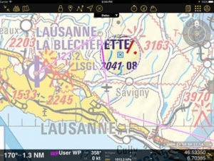
Then, eMotion will transmit this advisory—a batch of flight information—via the internet, to Air Navigation Pro’s server. Air Navigation Pro will then push this information out to all smart devices of connected Air Navigation users, enabling them to see details of the senseFly operator’s planned drone working area, such as its location, likely timings, height above the ground, type of drone, etc.—both prior to, and during* the GA pilot’s flight.

Phase 2: Airplane awareness for drone operators

In the coming months, senseFly drone operators will, in turn, gain the ability to view the Air Navigation users’ flights in real time**—making the Safer Together project the first system to provide bi-directional awareness of aerial activity for GA pilots and drone operators.

“At senseFly our background is in aviation,” said Cyril Halter, the COO of senseFly and a graduate of the Empire Test Pilot School. “Many of our founders and team members are pilots, so we understand how crucial ‘see and avoid’ awareness is for operational safety. Since we approach the development of our drones from a safety-first standpoint, it was a logical next step for us to join forces with Air Navigation Pro on Safer Together. This collaboration is about bridging the awareness gap between operators of our UAS—such as civil engineers, surveyors and agricultural professionals—and Air Navigation Pro’s community of GA users.”

“With the increasing number of vehicles in the air, it is essential that we focus on the improvement and awareness of mid-air safety,” said Johann Huguenin, the CEO of Air Navigation Pro. “It all starts with communication between the drone-operator and the pilot, which we are making possible with Safer Together. With senseFly’s aviation-style dedication to safety, and its global customer reach, it was the obvious partner for us to collaborate with first. However we strongly urge other drone makers to get in touch too, so that together we can continue to expand the benefits that Safer Together offers by allowing GA pilots to view the activity of every drone operation, whatever the brand of UAS”.

You can learn more about Safer Together here.

Here is a promotional video on the service.


* Requires the smart device running Air Navigation Pro to have an internet connection during flight.

** Requires the device running eMotion to have an internet connection.

Frank Schroth
Frank Schroth

Frank Schroth is editor in chief of DroneLife, the authoritative source for news and analysis on the drone industry: it’s people, products, trends, and events.
Email Frank
TWITTER:@fschroth

Filed Under: Applications, News Tagged With: Collision Avoidance, Collision Avoidance System, Safer Together, senseFly

Reader Interactions

Leave a Reply Cancel reply

Your email address will not be published. Required fields are marked *

Primary Sidebar

LATEST

Teledyne FLIR OEM Upgrades Prism SKR Software for Autonomous Target Recognition

New release combines mission execution and intelligent supervision in a single autonomy platform Teledyne FLIR OEM has announced an upgrade…

Continue Reading Teledyne FLIR OEM Upgrades Prism SKR Software for Autonomous Target Recognition

Drone Operations Software Company AirHub Closes €4.4M Series A

AirHub, a European drone operations software company based in The Hague, has closed a €4.4 million Series A funding round.…

Continue Reading Drone Operations Software Company AirHub Closes €4.4M Series A

Arrive AI Patents Shared Drone Delivery Endpoint With Tenth U.S. Patent

Arrive AI (NASDAQ: ARAI) has secured its tenth U.S. patent, strengthening its intellectual property portfolio for autonomous drone delivery infrastructure.…

Continue Reading Arrive AI Patents Shared Drone Delivery Endpoint With Tenth U.S. Patent

Korean eVTOL Developer Airbility Partners on UAV Public Safety in Thailand

South Korean eVTOL developer Airbility has signed a four-party Memorandum of Understanding to deploy UAV systems for public safety and…

Continue Reading Korean eVTOL Developer Airbility Partners on UAV Public Safety in Thailand

Is U.S. Manufacturing the Answer? SKYROVER Signals a New Strategy as FCC Pressure Mounts

A Hong Kong-based drone company outlines a five-year U.S. roadmap, raising questions about compliance, supply chains, and market access A…

Continue Reading Is U.S. Manufacturing the Answer? SKYROVER Signals a New Strategy as FCC Pressure Mounts

Blue Marble Geographics and Avenza Systems Combine to Create Unified Geospatial Platform

Merger connects office-based analysis with field operations for end-to-end spatial workflows Blue Marble Geographics and Avenza Systems, Inc. have announced…

Continue Reading Blue Marble Geographics and Avenza Systems Combine to Create Unified Geospatial Platform

Amazon Prime Air Adjusts Course After Richardson Setbacks

After rocky start in Texas city, Amazon Air service flying high By DRONELIFE Features Editor Jim Magill After only a…

Continue Reading Amazon Prime Air Adjusts Course After Richardson Setbacks

Airspace Security at 2026 JUNO Awards

RF-Cyber counter-drone system enables non-disruptive protection for large public event D-Fend Solutions announced that its EnforceAir counter-drone system was deployed…

Continue Reading Airspace Security at 2026 JUNO Awards

Will States Be Ready with Counter Drone Tech for the FIFA World Cup?

Funding snafu, other issues delay counter-UAS ramp-up in Maryland, elsewhere By DRONELIFE Features Editor Jim Magill (Editor’s note: This is…

Continue Reading Will States Be Ready with Counter Drone Tech for the FIFA World Cup?

Strait of Hormuz Tensions Highlight a Growing Role for Small Drone Surveillance

Maritime risk, insurance pressure, and degraded navigation signals point to new use cases for commercial UAV systems Ongoing tension in…

Continue Reading Strait of Hormuz Tensions Highlight a Growing Role for Small Drone Surveillance

Secondary Sidebar

Footer

SPONSORED

Inspired Flight Gremsy IF800 VIO F1 drones geo week

What Will It Take to Strengthen U.S. Drone Manufacturing? A Conversation with Inspired Flight’s CEO

Global Mapper Mobile data collection

Collection Ground Control Points with Global Mapper Mobile

Military Drone Mapping Solutions

How SimActive’s Correlator3D™ is Revolutionizing Military Mapping: An Exclusive Interview with CEO Philippe Simard

Photogrammetry Accuracy Standards

SimActive Photogrammetry Software: Enabling Users to Meet Accuracy Standards for Over 20 Years

NACT Engineering Parrot ANAFI tether indoor shot

Smart Tether for Parrot ANAFI USA from NACT Engineering

Blue Marble, features global mapper, features Blue Marble

Check Out These New Features in Global Mapper v25 from Blue Marble

About Us | Contact Us | Advertise With Us | Write for Us | Privacy Policy | Terms of Service

The Trusted Source for the Business of Drones.

This website uses cookies and third party services. By clicking OK, you are agreeing to our privacy policy. ACCEPT

Manage consent

Privacy Overview

This website uses cookies to improve your experience while you navigate through the website. Out of these, the cookies that are categorized as necessary are stored on your browser as they are essential for the working of basic functionalities of the website. We also use third-party cookies that help us analyze and understand how you use this website. These cookies will be stored in your browser only with your consent. You also have the option to opt-out of these cookies. But opting out of some of these cookies may affect your browsing experience.
Necessary
Always Enabled
Necessary cookies are absolutely essential for the website to function properly. These cookies ensure basic functionalities and security features of the website, anonymously.
CookieDurationDescription
cookielawinfo-checkbox-analytics11 monthsThis cookie is set by GDPR Cookie Consent plugin. The cookie is used to store the user consent for the cookies in the category "Analytics".
cookielawinfo-checkbox-functional11 monthsThe cookie is set by GDPR cookie consent to record the user consent for the cookies in the category "Functional".
cookielawinfo-checkbox-necessary11 monthsThis cookie is set by GDPR Cookie Consent plugin. The cookies is used to store the user consent for the cookies in the category "Necessary".
cookielawinfo-checkbox-others11 monthsThis cookie is set by GDPR Cookie Consent plugin. The cookie is used to store the user consent for the cookies in the category "Other.
cookielawinfo-checkbox-performance11 monthsThis cookie is set by GDPR Cookie Consent plugin. The cookie is used to store the user consent for the cookies in the category "Performance".
viewed_cookie_policy11 monthsThe cookie is set by the GDPR Cookie Consent plugin and is used to store whether or not user has consented to the use of cookies. It does not store any personal data.
Functional
Functional cookies help to perform certain functionalities like sharing the content of the website on social media platforms, collect feedbacks, and other third-party features.
Performance
Performance cookies are used to understand and analyze the key performance indexes of the website which helps in delivering a better user experience for the visitors.
Analytics
Analytical cookies are used to understand how visitors interact with the website. These cookies help provide information on metrics the number of visitors, bounce rate, traffic source, etc.
Advertisement
Advertisement cookies are used to provide visitors with relevant ads and marketing campaigns. These cookies track visitors across websites and collect information to provide customized ads.
Others
Other uncategorized cookies are those that are being analyzed and have not been classified into a category as yet.
SAVE & ACCEPT