• Skip to main content
  • Skip to secondary menu
  • Skip to primary sidebar
  • Skip to secondary sidebar
  • Skip to footer
  • DroneRacingLife
  • DroneFlyers
  • Newsletter
DroneLife

DRONELIFE

Stay up to date on all the latest Drone News

  • News
  • Products
  • Industries
    • Agriculture
    • Construction
    • Delivery
    • Dual Use
    • Inspection
    • Public Safety
    • Surveying
  • Enthusiasts
  • Regulations
  • Business
  • Video
  • Podcasts

Professional Insights into Thermal Imaging with a Drone

June 8, 2016 by Frank Schroth 6 Comments

Sponsored post by David Lee, Marketing Manager, FLIR Systems —

Thermal imaging is a key technology sUAS operators have wanted to get their hands on for years. Certainly, the uses for thermal are well-known and wide-spread – from search and rescue (SAR) to building inspections, from utility and transportation to precision ag, thermal cameras provide capabilities that no other technology can.

But that can be a double-edged sword. Thermal imaging can help operators see the invisible and do exciting things to save lives and protect resources…but it’s not a magic bullet. Like any other imaging technology, thermal will gives the best results when used in certain conditions, and when the operator knows how to properly interpret the images they’re seeing. In order to do this, operators need to have a basic understanding of how thermal imagers work, and how to set themselves up for success.

A little background…

Put simply, thermal imagers detect and display differences in the thermal energy given off by objects within the field of view. Thermal energy (also called “heat energy”) is around us all the time. In fact, it’s given off by everything about Absolute Zero – the temperature at which all molecular activity stops.

Therefore, any given scene will contain a number of items that are sources of thermal energy. The trick is understanding why an object is giving off that energy and what it signifies.

Into the weeds…

One way people unwittingly cause confusion in the thermal imaging world is by using temperature and thermal or heat energy interchangeably. These are not the same thing. Most people are unaware that “heat energy” and “temperature” are different. Heat is a form of energy. It cannot be measured; only its effects can. Temperature is a measure of the kinetic energy of molecules within an object expressed against a known scale (like Fahrenheit or Celsius). Thermographers use specialized radiometric cameras and software to convert the thermal energy seen with the camera into an accurate temperature measurement, but that’s another topic altogether. Let’s stick with basic thermal imaging for now.

Some objects generate their own heat energy (people and other warm-blooded animals), while others absorb energy from the sun and radiate that back into the atmosphere. Different objects generate or radiate different amounts of energy based on such factors as their composition, their surface textures, and the surrounding conditions. It’s these differences that allow thermal imagers to create the images you see.

If you do any research at all into what makes thermal imaging work you’re bound to run into a very important word: Emissivity. Emissivity can be thought of as the efficiency with which an object gives off heat energy. Warm-blooded animals are typically very efficient radiators, so we say that they’re “highly emissive.” Things get a little more complicated when we start looking at everything else in the world – those things that absorb the sun’s energy and radiate it back into the environment. Some are very efficient and some are not.

With very few exceptions, all of the energy you see in a thermal image has either been emitted (given off) or reflected (bounced back). Usually is an image will contain a combination of the two. Material that is a good emitter (dirt, rocks, concrete) is not a good reflector. Conversely, a highly reflective material (shiny metal, glass) is more likely to show you the radiation it’s reflecting from objects around it rather than its true thermal energy state.

Why do I care?

So, what does all this have to do with using a thermal camera from a drone? Well, let’s take a SAR mission as an example.

Trying to find a person in a wide open area with lots of exposed soil, rocks and other organic material can be extremely difficult if the sun is out and the surface objects have been absorbing thermal energy from the sun for a few hours. Because all of these objects will have high emissivity – meaning that they both absorb and emit energy very efficiently – they can easily overwhelm the radiation given off by the person you’re looking for.

This is where the difference between temperature and thermal energy comes into play. If you’re looking for a person in the desert, with lots of exposed rock and soil, in the early afternoon on a sunny day you could have just as hard a time finding them if it’s 50°F or 90°F because the ground has become saturated with thermal energy (a condition called “solar loading”).

You can set yourself up for success by flying earlier in the day – preferably before your search area is exposed to the sun – or when the sun is below the horizon. Also, if there’s cloud cover the effects of solar loading will be greatly reduced. If you’re not searching an area of bare ground, try positioning the aircraft so you’ll be searching shadowed areas. This will create a natural area of greater energy difference that will make your target easier to spot.

Another important factor is the color palette you select. Many cameras like the Flir Vue Pro and Zenmuse XT include color palettes that are optimized for specific tasks, like industrial inspections or building surveys. While these can be fun to look at and make great images of electrical components with overheating problems, they’re not the best for a search and rescue (SAR) mission. Black Hot or White Hot palette are the better choices for SAR.

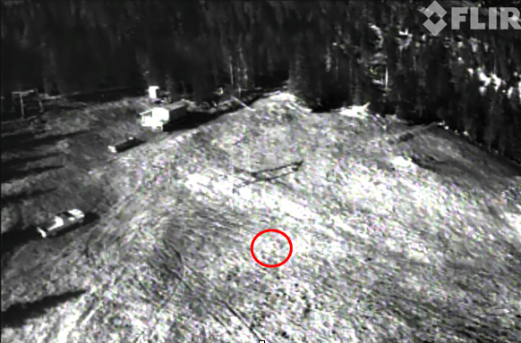
The following images illustrate the issue between temperature and thermal energy.

SAR Image 1

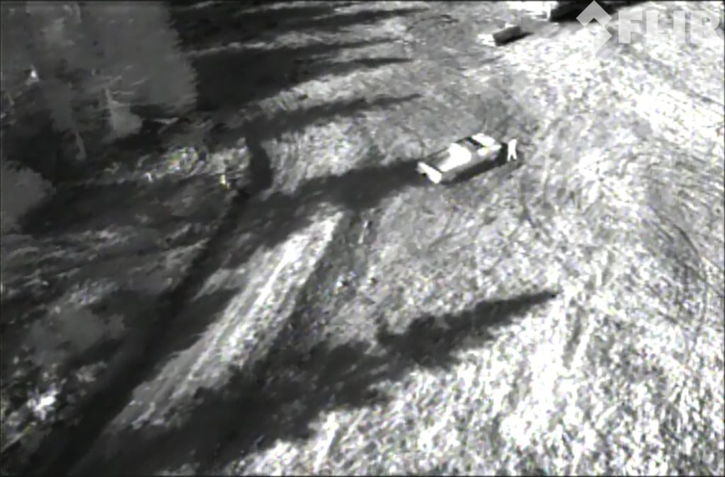
In this image, the person is clearly visible near the front of his truck. Note the areas of open ground that are brighter than the surrounding area. This is where the soil is raised in mounds a few feet high. They have better drainage, are dryer than the lower, darker areas, and are angled to meet the rising sun more directly so they’re absorbing more thermal energy. All of these factors combine to create more solar loading in those areas.

SAR Image 2

The target has walked away from the truck and is barely visible to the right of the center of the image. He is walking through a slight depression where the soil  is again muddier than the surrounding high spots.

Screen Shot 2016-06-08 at 8.00.28 AM

The target has continued walking in the same direction. He is now crossing a raised, rocky area and has effectively disappeared from the view even though he’s standing in the open. As he crossed this area and entered the muddy ground downhill from his current position he became clearly visible again.

Takeaways

So, for everyone excited about using a thermal imager, are we saying not to get one? Absolutely not. However, we want to emphasize that deploying one in a tactical situation or on a roof inspection is something that takes practice and study. Don’t show up at a search location or a job site expecting the person or problem to stick out like a sore thumb unless you use the tools at your disposal correctly. Use online resources or get some training so that you’ll understand what you’re seeing and why it looks that way.

It will be worth it.

Frank Schroth
Frank Schroth

Frank Schroth is editor in chief of DroneLife, the authoritative source for news and analysis on the drone industry: it’s people, products, trends, and events.
Email Frank
TWITTER:@fschroth

Filed Under: Fire and Police, Industries Tagged With: FLIR Systems, Thermal Imaging

Reader Interactions

Comments

  1. IRSV says

    March 19, 2017 at 11:07 pm

    very good topic, I think it would be better if change setting on the thermail camera to different color, or set the porper temperature you interested

    Reply
  2. John Ferrell says

    January 18, 2017 at 5:48 pm

    I didn’t know that it would cause problems with thermal imaging if the plants were exposed to a lot of sun. If I was going to use thermal imaging then I would want to know that it is going to work properly. I think that it might be a good idea to find out what some of the potential problems could be when doing the imaging.

    Reply
  3. kim goodwin says

    December 15, 2016 at 4:14 am

    Thanks for this article, FRANK SCHROTH. I got a complete information about thermal imaging with the drone in this article. But, with drone, it can be made more functional. Thanks for the information dude..

    Reply
  4. Elizabeth casserino says

    November 14, 2016 at 10:39 am

    Hello, I am a student at Syracuse University and have I found your article very interesting as I am doing a project that involves both drones and thermal cameras. It would be great if I could ask you a few questions on this topic!

    Reply
  5. Doug says

    October 24, 2016 at 8:09 am

    That was very helpful. I’m interested in SAR with a drone and this gave a lot of insight.

    Reply
  6. Clark says

    October 12, 2016 at 3:01 am

    Thank you for your insight David.

    Reply

Leave a Reply Cancel reply

Your email address will not be published. Required fields are marked *

Primary Sidebar

LATEST

Parallel Flight and Alpha Unmanned Systems Partner for Heavy-Fuel UAS System

Parallel Flight Technologies and Alpha Unmanned Systems have partnered to develop new heavy-fuel UAS technology for naval research under a…

Continue Reading Parallel Flight and Alpha Unmanned Systems Partner for Heavy-Fuel UAS System

Nearmap and New Light Deploy FEMA Disaster Response System.

Nearmap and New Light Technologies have deepened their collaboration to support the Federal Emergency Management Agency (FEMA) during major natural…

Continue Reading Nearmap and New Light Deploy FEMA Disaster Response System.

GAO Signals Rising Scrutiny as Drone Deliveries Expand

Federal watchdog highlights safety and oversight challenges as BVLOS operations grow Drone delivery in the United States continues to expand.…

Continue Reading GAO Signals Rising Scrutiny as Drone Deliveries Expand

Gather AI Raises $40 Million for Warehousing Tech

Gather AI’s latest funding round underscores growing demand for drone-based inventory intelligence in large, complex warehouses. The Pittsburgh-based company has raised $40…

Continue Reading Gather AI Raises $40 Million for Warehousing Tech

Corvus Robotics Unveils Drone System for Cold Chain Operations

Corvus Robotics has introduced Corvus One for Cold Chain, an autonomous aerial inventory system designed to operate in freezer environments…

Continue Reading Corvus Robotics Unveils Drone System for Cold Chain Operations

Ohio Identifies First Participants in Nation’s Only Statewide Drone First Responder Pilot

Nine public safety agencies selected to test rapid, drone-based emergency response across the state Ohio has taken a major step…

Continue Reading Ohio Identifies First Participants in Nation’s Only Statewide Drone First Responder Pilot

Teledyne FLIR OEM Introduces Its Longest-Range Thermal ISR Camera to Date

New infrared module targets extended-range surveillance and counter-UAS missions while addressing U.S. compliance needs Teledyne FLIR OEM has announced the…

Continue Reading Teledyne FLIR OEM Introduces Its Longest-Range Thermal ISR Camera to Date

Paladin Unveils New First Responder Drone: Knighthawk 2.0

Paladin has introduced Knighthawk 2.0, an autonomous NDAA-compliant drone designed as public safety infrastructure for Drone as a First Responder (DFR) programs…

Continue Reading Paladin Unveils New First Responder Drone: Knighthawk 2.0

Windracers Expands Scottish Highlands Cargo Drone Project

British heavy-lift drone manufacturer Windracers has signed a Memorandum of Understanding (MoU) with the Highlands and Islands Transport Partnership (HITRANS) to accelerate the deployment…

Continue Reading Windracers Expands Scottish Highlands Cargo Drone Project

Two Days Left: FAA Reopens BVLOS Comments on Some of the Hardest Airspace Questions

Agency narrows focus to electronic conspicuity and right-of-way as February 11 deadline approaches Just two days remaining to comment, as…

Continue Reading Two Days Left: FAA Reopens BVLOS Comments on Some of the Hardest Airspace Questions

Secondary Sidebar

Footer

SPONSORED

Inspired Flight Gremsy IF800 VIO F1 drones geo week

What Will It Take to Strengthen U.S. Drone Manufacturing? A Conversation with Inspired Flight’s CEO

Global Mapper Mobile data collection

Collection Ground Control Points with Global Mapper Mobile

Military Drone Mapping Solutions

How SimActive’s Correlator3D™ is Revolutionizing Military Mapping: An Exclusive Interview with CEO Philippe Simard

Photogrammetry Accuracy Standards

SimActive Photogrammetry Software: Enabling Users to Meet Accuracy Standards for Over 20 Years

NACT Engineering Parrot ANAFI tether indoor shot

Smart Tether for Parrot ANAFI USA from NACT Engineering

Blue Marble, features global mapper, features Blue Marble

Check Out These New Features in Global Mapper v25 from Blue Marble

About Us | Contact Us | Advertise With Us | Write for Us | Privacy Policy | Terms of Service

The Trusted Source for the Business of Drones.

This website uses cookies and third party services. By clicking OK, you are agreeing to our privacy policy. ACCEPT

Manage consent

Privacy Overview

This website uses cookies to improve your experience while you navigate through the website. Out of these, the cookies that are categorized as necessary are stored on your browser as they are essential for the working of basic functionalities of the website. We also use third-party cookies that help us analyze and understand how you use this website. These cookies will be stored in your browser only with your consent. You also have the option to opt-out of these cookies. But opting out of some of these cookies may affect your browsing experience.
Necessary
Always Enabled
Necessary cookies are absolutely essential for the website to function properly. These cookies ensure basic functionalities and security features of the website, anonymously.
CookieDurationDescription
cookielawinfo-checkbox-analytics11 monthsThis cookie is set by GDPR Cookie Consent plugin. The cookie is used to store the user consent for the cookies in the category "Analytics".
cookielawinfo-checkbox-functional11 monthsThe cookie is set by GDPR cookie consent to record the user consent for the cookies in the category "Functional".
cookielawinfo-checkbox-necessary11 monthsThis cookie is set by GDPR Cookie Consent plugin. The cookies is used to store the user consent for the cookies in the category "Necessary".
cookielawinfo-checkbox-others11 monthsThis cookie is set by GDPR Cookie Consent plugin. The cookie is used to store the user consent for the cookies in the category "Other.
cookielawinfo-checkbox-performance11 monthsThis cookie is set by GDPR Cookie Consent plugin. The cookie is used to store the user consent for the cookies in the category "Performance".
viewed_cookie_policy11 monthsThe cookie is set by the GDPR Cookie Consent plugin and is used to store whether or not user has consented to the use of cookies. It does not store any personal data.
Functional
Functional cookies help to perform certain functionalities like sharing the content of the website on social media platforms, collect feedbacks, and other third-party features.
Performance
Performance cookies are used to understand and analyze the key performance indexes of the website which helps in delivering a better user experience for the visitors.
Analytics
Analytical cookies are used to understand how visitors interact with the website. These cookies help provide information on metrics the number of visitors, bounce rate, traffic source, etc.
Advertisement
Advertisement cookies are used to provide visitors with relevant ads and marketing campaigns. These cookies track visitors across websites and collect information to provide customized ads.
Others
Other uncategorized cookies are those that are being analyzed and have not been classified into a category as yet.
SAVE & ACCEPT