 DroneDeploy, the cloud-based software system for aerial imaging and analysis published a report Commercial Drone Industry Trends today. In it they provide data and metrics that provide unique insights into how and where drone technology is being used. While it is only one company’s experience, it represents hard evidence to validate a variety of market projections made over the last year. Specifically, it shows that the drone industry appears to be poised for rapid growth.
The publication of this report was prompted by their top line metric, acres mapped. In one year, DroneDeploy users mapped one million acres. At the time, that was viewed as a significant milestone. Yet, DroneDeploy users have now doubled that to 2 million acres in less than 4 months.
DRONELIFE had a conversation with Mike Winn, CEO of DroneDeploy, and Darr Gerscovich, SVP of Marketing. They note several key metrics and insights that provide a snapshot of where the industry is today. First, users are leveraging drones to create very large maps (e.g. 1,000+ acres), often very economically, using DJI phantoms with 3 – 4 batteries. This in turn indicates that many drone manufactures (including “consumer” drones) and camera manufacturers are vying for the emerging commercial drone market. Second, there is a relatively high adoption of 3D mapping by users. Third, a surprising percentage of users own more than one drone.
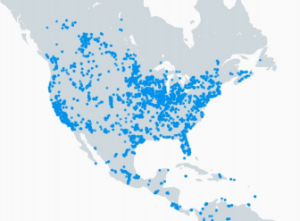
Some of the data also indicate the potential growth of the drone industry. As Winn and Gersovich noted in our conversation, the adoption is worldwide. While the penetration is greatest in North America and Europe, it is also taking place in South America and Africa.
Perhaps most important, counter to perception, there’s been high US and EU adoption despite a somewhat challenging regulatory environment. When the FAA issues revised regulations around the commercial use of drones, expected in June / July of this year, it would be reasonable to expect a significant spike. This could be the cusp of a hockey stick in terms of growth of the industry across markets and boundaries.
Other highlights include:
- commercial drones in Europe are primarily used for surveying, while in South America they primarily support agriculture
- agriculture is the largest commercial sector for drones
- the average agricultural map is 120 acres (49 hectares), which is almost twice as large as the next largest industry segment, surveying.
To see the full insights reported, visit the DroneDeploy blog.
DroneDeploy’s cloud-based system can accept data from any drone. The company offers a free app for DJI drones that automates the capture of aerial data. It is available for iOS and Android.
CEO Winn concluded, “We are making the skies more accessible to everyone by making drones as easy to use and insightful as possible.”
Frank Schroth is editor in chief of DroneLife, the authoritative source for news and analysis on the drone industry: it’s people, products, trends, and events.
Email Frank
TWITTER:@fschroth


Leave a Reply