
• Skip to main content
  • Skip to secondary menu
  • Skip to primary sidebar
  • Skip to secondary sidebar
  • Skip to footer
  • DroneRacingLife
  • DroneFlyers
  • Newsletter
DroneLife

DRONELIFE

Stay up to date on all the latest Drone News

  • News
  • Products
  • Industries
    • Agriculture
    • Construction
    • Delivery
    • Dual Use
    • Inspection
    • Public Safety
    • Surveying
  • Enthusiasts
  • Regulations
  • Business
  • Video
  • Podcasts

5 Tips for Better Drone Photos

December 27, 2016 by Malek Murison 2 Comments

Maybe you’ve just got a drone for Christmas or maybe you’ve been flying for a while. Either way, we’re all looking for some easy steps to take to improve our aerial photography and make the most of having an eye in the sky. Here are our five top tips for better drone photos.

Think about the time of day

One thing that many pilots don’t consider when planning a flight is the time of day. We’re not talking about day or night. We’re talking about the difference between morning, midday and afternoon, which is huge in the world of photography.

When it comes to light quality, the time of day you choose to fly at is going to have a significant impact. For example, first thing in the morning the light is going to be softer and create more contrast in your photos and videos. Colours will come across as more warm in the early morning and late afternoon because the sun will be lower in the sky. More often than not, this makes these particular times of day best for landscape photography and better drone photos in general.   

Choosing a good time of day for aerial photography can help you blend shadow and texture into your shots.

Read more: Top Resources to Improve Your Aerial Photography

Obviously, the main impact that the time of day has on your photography will be the direction that the light is coming from. Aerial photographers wanting to make the most of the interplay between sun and landscape will have to take the direction of light into account. For a detailed view of what the light is doing at your chosen location at a chosen time, try using the iOS app Photopills or The Photographer’s Ephemeris on android.

Make the most of altitude

Your camera is attached to a drone, so you might as well make the most of it. Half of the fun of drone photography is capturing landscapes and objects from new angles and perspectives.

It goes without saying that the higher you are, the more landscape features you’ll be able to cram into your shots. Alternatively, a close-up from above can also offer a unique and engaging perspective. Better drone photos require a little experimentation, so vary your altitude and see how it goes. 

Plan your shots and reap the rewards

We’ve already mentioned the importance of factoring in what the light conditions will be like for your aerial shoot. But while thinking about the time of day is vital, it’s also worth thinking about your flight plan and how the two will intertwine.
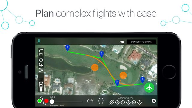
Airnest 2.0 plan tool better drone photos
Apps such as Airnest allow for detailed but simple flight planning.

Having a flight plan in mind and (ideally) pre-programmed allows you to think about your subject and decide how best to capture it. You’re bound to get better results having pre-planned your routes and altitudes, so why wing it?

Shoot in RAW

What does that even mean? Well, RAW is a file format, just like JPEG or MP4. The difference is that it captures all of the image data recorded by your drone when you take a photo. Often shooting in a format like JPEG means that images are compressed and vital detail is lost. RAW allows you to produce higher quality images that you can then process afterwards, changing the subtle details that would be unrecoverable if shot in another format.

Post-processing

We’ve been through the importance of post-processing before. Often your photos and videos will require a bit of touching up to bring the best out of them, whether that’s editing the contrast, bracketing, cutting videos down to the highlights, or resizing, straightening and colour correcting images.

There are plenty of software packages you can use to bring out the best in your drone photography. Check out our separate post on post-processing and video editing tools. 

Malek Murison
Malek Murison

Malek Murison is a freelance writer and editor with a passion for tech trends and innovation. He handles product reviews, major releases and keeps an eye on the enthusiast market for DroneLife.
Email Malek
Twitter:@malekmurison

Subscribe to DroneLife here.

Filed Under: Enthusiasts, Helpful Hints, News, Video Tagged With: aerial photography, Light, RAW

Reader Interactions

Trackbacks

  1. 5 Tips for Better sUAS/UAV Photos | Icon Aerial Media says:
    December 28, 2016 at 7:52 am

    […] 5 Tips for Better Drone Photos […]

    Reply
  2. 5 Tips for Better Drone Photos | AllDrones.com says:
    December 27, 2016 at 11:42 pm

    […] post 5 Tips for Better Drone Photos appeared first on […]

    Reply

Leave a Reply Cancel reply

Your email address will not be published. Required fields are marked *

Primary Sidebar

LATEST

From Maps to Operational Intelligence: How Defense Is Changing the Mapping Workflow

From the INTERGEO show floor in Munich, SimActive CEO Philippe Simard discusses why speed, usability and data integration increasingly matter…

Continue Reading From Maps to Operational Intelligence: How Defense Is Changing the Mapping Workflow

Flytrex Adds Rooftop Drone Docks and AI Fleet Positioning in Dallas

The company says prepositioning drones at restaurants can cut delivery costs by 60% and reduce delivery times by half. Flytrex…

Continue Reading Flytrex Adds Rooftop Drone Docks and AI Fleet Positioning in Dallas

From Wildfire Detection to Fast Mapping: AIVE AI Systems Expands Access to Geospatial Data

The startup is developing tools that create georeferenced 2D maps from a small number of images, without requiring specialized infrastructure.…

Continue Reading From Wildfire Detection to Fast Mapping: AIVE AI Systems Expands Access to Geospatial Data

FirstEnergy Grant Expands Drone Training for Educators and Police

WarrenUAS will use the funding to provide FAA Part 107 preparation and hands-on flight training in New Jersey. A FirstEnergy…

Continue Reading FirstEnergy Grant Expands Drone Training for Educators and Police

Airwise Solutions and UAS Sentry Integrate Drone Detection and Airspace Intelligence

Partnership brings Remote ID detection into a common operating picture for critical infrastructure, public safety and enterprise users. Airwise Solutions…

Continue Reading Airwise Solutions and UAS Sentry Integrate Drone Detection and Airspace Intelligence

GeoCue Launches TrueView 550 Aerial LiDAR System at INTERGEO

New system combines advanced LiDAR, dual mapping cameras and two positioning options for professional surveying and mapping. GeoCue has expanded…

Continue Reading GeoCue Launches TrueView 550 Aerial LiDAR System at INTERGEO

The Drone Is No Longer the Point

At INTERGEO, attention has shifted from individual platforms to complete geospatial workflows. One of the clearest drone industry trends at…

Continue Reading The Drone Is No Longer the Point

FCC Clears Nationwide Test of Cellular Networks for Drone Safety

Temporary waiver will allow DOT to measure airborne wireless coverage for command and control, detect and avoid, Remote ID and…

Continue Reading FCC Clears Nationwide Test of Cellular Networks for Drone Safety

From Cars to Drones: Birdstop Taps Detroit’s Auto Supply Chain to Scale U.S. Manufacturing

UAV maker turns to auto industry as source of domestic components By DRONELIFE Features Editor Jim Magill While Silicon Valley…

Continue Reading From Cars to Drones: Birdstop Taps Detroit’s Auto Supply Chain to Scale U.S. Manufacturing

Wingcopter 262 Debuts as All-Electric Tactical Reconnaissance eVTOL for Defense Users

The all-electric Wingcopter 262 carries a 262-centimeter (103-inch) wingspan, a 150-kilometer (93-mile) tactical range and a 10-kilogram (22-pound) maximum takeoff…

Continue Reading Wingcopter 262 Debuts as All-Electric Tactical Reconnaissance eVTOL for Defense Users

Secondary Sidebar

Footer

SPONSORED

What Is the Best Commercial Cleaning Drone in 2026? Specs, Prices, and a Head-to-Head Comparison

Inspired Flight Gremsy IF800 VIO F1 drones geo week

What Will It Take to Strengthen U.S. Drone Manufacturing? A Conversation with Inspired Flight’s CEO

Global Mapper Mobile data collection

Collection Ground Control Points with Global Mapper Mobile

Military Drone Mapping Solutions

How SimActive’s Correlator3D™ is Revolutionizing Military Mapping: An Exclusive Interview with CEO Philippe Simard

Photogrammetry Accuracy Standards

SimActive Photogrammetry Software: Enabling Users to Meet Accuracy Standards for Over 20 Years

NACT Engineering Parrot ANAFI tether indoor shot

Smart Tether for Parrot ANAFI USA from NACT Engineering

About Us | Contact Us | Advertise With Us | Write for Us | Privacy Policy | Terms of Service

The Trusted Source for the Business of Drones.

This website uses cookies and third party services. By clicking OK, you are agreeing to our privacy policy. ACCEPT

Manage consent

Privacy Overview

This website uses cookies to improve your experience while you navigate through the website. Out of these, the cookies that are categorized as necessary are stored on your browser as they are essential for the working of basic functionalities of the website. We also use third-party cookies that help us analyze and understand how you use this website. These cookies will be stored in your browser only with your consent. You also have the option to opt-out of these cookies. But opting out of some of these cookies may affect your browsing experience.
Necessary
Always Enabled
Necessary cookies are absolutely essential for the website to function properly. These cookies ensure basic functionalities and security features of the website, anonymously.
CookieDurationDescription
cookielawinfo-checkbox-analytics11 monthsThis cookie is set by GDPR Cookie Consent plugin. The cookie is used to store the user consent for the cookies in the category "Analytics".
cookielawinfo-checkbox-functional11 monthsThe cookie is set by GDPR cookie consent to record the user consent for the cookies in the category "Functional".
cookielawinfo-checkbox-necessary11 monthsThis cookie is set by GDPR Cookie Consent plugin. The cookies is used to store the user consent for the cookies in the category "Necessary".
cookielawinfo-checkbox-others11 monthsThis cookie is set by GDPR Cookie Consent plugin. The cookie is used to store the user consent for the cookies in the category "Other.
cookielawinfo-checkbox-performance11 monthsThis cookie is set by GDPR Cookie Consent plugin. The cookie is used to store the user consent for the cookies in the category "Performance".
viewed_cookie_policy11 monthsThe cookie is set by the GDPR Cookie Consent plugin and is used to store whether or not user has consented to the use of cookies. It does not store any personal data.
Functional
Functional cookies help to perform certain functionalities like sharing the content of the website on social media platforms, collect feedbacks, and other third-party features.
Performance
Performance cookies are used to understand and analyze the key performance indexes of the website which helps in delivering a better user experience for the visitors.
Analytics
Analytical cookies are used to understand how visitors interact with the website. These cookies help provide information on metrics the number of visitors, bounce rate, traffic source, etc.
Advertisement
Advertisement cookies are used to provide visitors with relevant ads and marketing campaigns. These cookies track visitors across websites and collect information to provide customized ads.
Others
Other uncategorized cookies are those that are being analyzed and have not been classified into a category as yet.
SAVE & ACCEPT




