• Skip to main content
  • Skip to secondary menu
  • Skip to primary sidebar
  • Skip to secondary sidebar
  • Skip to footer
  • DroneRacingLife
  • DroneFlyers
  • Newsletter
DroneLife

DRONELIFE

Stay up to date on all the latest Drone News

  • News
  • Products
  • Industries
    • Agriculture
    • Construction
    • Delivery
    • Dual Use
    • Inspection
    • Public Safety
    • Surveying
  • Enthusiasts
  • Regulations
  • Business
  • Video
  • Podcasts

Eos Launches Photogrammetry Suite for Drones

November 3, 2016 by Jason Reagan 1 Comment

pob-eos-photomodeler-10282016Eos Systems recently released a photogrammetry software package created specifically for drones.

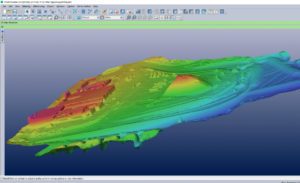
This past week, the Canadian firm announced the launch of PhotoModeler UAS 2016. The suite creates 3D imagery, maps and measurements from images transmitted via drone and integrates them with full geographic coordinate systems support.

“Photogrammetry has been our passion for over 20 years, and we are very excited by the response [PhotoModeler] has been getting from the drone market,” Eos CEO Alan Walford said in a recent DroneLife interview.

The company demonstrated the software at the 2016 Commercial UAV Expo in Las Vegas this past week. “We expect PhotoModeler UAS to play a key role in the rapidly growing UAS survey industry,” Walford said. Eos plans to offer the software at a reduced price of $2,275 through November.

PhotoModeler features post-processing kinematics (PPK), volume objects, full geographic coordinate systems support, multispectral image support and control point assistance.

“We can utilize a drone and fly a 43-acre site in minutes and PhotoModeler will take that data and provide the output we are looking for to effectively manage the project for our clients,” stated one Eos customer.

With post-processing kinematics, the software can correct a drone-driven survey mission with GPS data for greater accuracy which could prove powerful for precision industries such as agriculture, mining, construction and utility inspection surveys.

“Volume objects provide easy and accurate volume data for stock piles and mining operations. Full geographic coordinate system support enables users to work in their local geographic coordinate system for better compatibility,” Walford added.

“Support is provided for multispectral images including normalized difference vegetation index (NDVI) surface models and ortho-mosaics for precision agriculture. An intuitive interface is provided for efficiently marking ground control points.”

The marriage of surveying-drone technology and photogrammetry is expected to grow into a healthy trend-line in years to come. As a job-growth trend, photogrammetry came in 15th on a list of high-growth vocations, according to Bureau of Labor Statistics data. Photogrammetry jobs are expected to grow at a rate of 29 percent with a median salary of $60,930.


Jason Reagan
Jason Reagan

Jason is a longstanding contributor to DroneLife with an avid interest in all things tech. He focuses on anti-drone technologies and the public safety sector; police, fire, and search and rescue.

Beginning his career as a journalist in 1996, Jason has since written and edited thousands of engaging news articles, blog posts, press releases and online content.

Email Jason
TWITTER:@JasonPReagan

LinkedIn 

Subscribe to DroneLife here.

Filed Under: Inspection, News Tagged With: Eos, inspection drones, photogrammetry, PhotoModeler

Reader Interactions

Trackbacks

  1. Eos Launches Photogrammetry Suite for Drones | Drone, UAV, Quadcopter a Multi Rotor News says:
    November 3, 2016 at 5:36 pm

    […] post Eos Launches Photogrammetry Suite for Drones appeared first on […]

    Reply

Leave a Reply Cancel reply

Your email address will not be published. Required fields are marked *

Primary Sidebar

LATEST

Parallel Flight and Alpha Unmanned Systems Partner for Heavy-Fuel UAS System

Parallel Flight Technologies and Alpha Unmanned Systems have partnered to develop new heavy-fuel UAS technology for naval research under a…

Continue Reading Parallel Flight and Alpha Unmanned Systems Partner for Heavy-Fuel UAS System

Nearmap and New Light Deploy FEMA Disaster Response System.

Nearmap and New Light Technologies have deepened their collaboration to support the Federal Emergency Management Agency (FEMA) during major natural…

Continue Reading Nearmap and New Light Deploy FEMA Disaster Response System.

GAO Signals Rising Scrutiny as Drone Deliveries Expand

Federal watchdog highlights safety and oversight challenges as BVLOS operations grow Drone delivery in the United States continues to expand.…

Continue Reading GAO Signals Rising Scrutiny as Drone Deliveries Expand

Gather AI Raises $40 Million for Warehousing Tech

Gather AI’s latest funding round underscores growing demand for drone-based inventory intelligence in large, complex warehouses. The Pittsburgh-based company has raised $40…

Continue Reading Gather AI Raises $40 Million for Warehousing Tech

Corvus Robotics Unveils Drone System for Cold Chain Operations

Corvus Robotics has introduced Corvus One for Cold Chain, an autonomous aerial inventory system designed to operate in freezer environments…

Continue Reading Corvus Robotics Unveils Drone System for Cold Chain Operations

Ohio Identifies First Participants in Nation’s Only Statewide Drone First Responder Pilot

Nine public safety agencies selected to test rapid, drone-based emergency response across the state Ohio has taken a major step…

Continue Reading Ohio Identifies First Participants in Nation’s Only Statewide Drone First Responder Pilot

Teledyne FLIR OEM Introduces Its Longest-Range Thermal ISR Camera to Date

New infrared module targets extended-range surveillance and counter-UAS missions while addressing U.S. compliance needs Teledyne FLIR OEM has announced the…

Continue Reading Teledyne FLIR OEM Introduces Its Longest-Range Thermal ISR Camera to Date

Paladin Unveils New First Responder Drone: Knighthawk 2.0

Paladin has introduced Knighthawk 2.0, an autonomous NDAA-compliant drone designed as public safety infrastructure for Drone as a First Responder (DFR) programs…

Continue Reading Paladin Unveils New First Responder Drone: Knighthawk 2.0

Windracers Expands Scottish Highlands Cargo Drone Project

British heavy-lift drone manufacturer Windracers has signed a Memorandum of Understanding (MoU) with the Highlands and Islands Transport Partnership (HITRANS) to accelerate the deployment…

Continue Reading Windracers Expands Scottish Highlands Cargo Drone Project

Two Days Left: FAA Reopens BVLOS Comments on Some of the Hardest Airspace Questions

Agency narrows focus to electronic conspicuity and right-of-way as February 11 deadline approaches Just two days remaining to comment, as…

Continue Reading Two Days Left: FAA Reopens BVLOS Comments on Some of the Hardest Airspace Questions

Secondary Sidebar

Footer

SPONSORED

Inspired Flight Gremsy IF800 VIO F1 drones geo week

What Will It Take to Strengthen U.S. Drone Manufacturing? A Conversation with Inspired Flight’s CEO

Global Mapper Mobile data collection

Collection Ground Control Points with Global Mapper Mobile

Military Drone Mapping Solutions

How SimActive’s Correlator3D™ is Revolutionizing Military Mapping: An Exclusive Interview with CEO Philippe Simard

Photogrammetry Accuracy Standards

SimActive Photogrammetry Software: Enabling Users to Meet Accuracy Standards for Over 20 Years

NACT Engineering Parrot ANAFI tether indoor shot

Smart Tether for Parrot ANAFI USA from NACT Engineering

Blue Marble, features global mapper, features Blue Marble

Check Out These New Features in Global Mapper v25 from Blue Marble

About Us | Contact Us | Advertise With Us | Write for Us | Privacy Policy | Terms of Service

The Trusted Source for the Business of Drones.

This website uses cookies and third party services. By clicking OK, you are agreeing to our privacy policy. ACCEPT

Manage consent

Privacy Overview

This website uses cookies to improve your experience while you navigate through the website. Out of these, the cookies that are categorized as necessary are stored on your browser as they are essential for the working of basic functionalities of the website. We also use third-party cookies that help us analyze and understand how you use this website. These cookies will be stored in your browser only with your consent. You also have the option to opt-out of these cookies. But opting out of some of these cookies may affect your browsing experience.
Necessary
Always Enabled
Necessary cookies are absolutely essential for the website to function properly. These cookies ensure basic functionalities and security features of the website, anonymously.
CookieDurationDescription
cookielawinfo-checkbox-analytics11 monthsThis cookie is set by GDPR Cookie Consent plugin. The cookie is used to store the user consent for the cookies in the category "Analytics".
cookielawinfo-checkbox-functional11 monthsThe cookie is set by GDPR cookie consent to record the user consent for the cookies in the category "Functional".
cookielawinfo-checkbox-necessary11 monthsThis cookie is set by GDPR Cookie Consent plugin. The cookies is used to store the user consent for the cookies in the category "Necessary".
cookielawinfo-checkbox-others11 monthsThis cookie is set by GDPR Cookie Consent plugin. The cookie is used to store the user consent for the cookies in the category "Other.
cookielawinfo-checkbox-performance11 monthsThis cookie is set by GDPR Cookie Consent plugin. The cookie is used to store the user consent for the cookies in the category "Performance".
viewed_cookie_policy11 monthsThe cookie is set by the GDPR Cookie Consent plugin and is used to store whether or not user has consented to the use of cookies. It does not store any personal data.
Functional
Functional cookies help to perform certain functionalities like sharing the content of the website on social media platforms, collect feedbacks, and other third-party features.
Performance
Performance cookies are used to understand and analyze the key performance indexes of the website which helps in delivering a better user experience for the visitors.
Analytics
Analytical cookies are used to understand how visitors interact with the website. These cookies help provide information on metrics the number of visitors, bounce rate, traffic source, etc.
Advertisement
Advertisement cookies are used to provide visitors with relevant ads and marketing campaigns. These cookies track visitors across websites and collect information to provide customized ads.
Others
Other uncategorized cookies are those that are being analyzed and have not been classified into a category as yet.
SAVE & ACCEPT