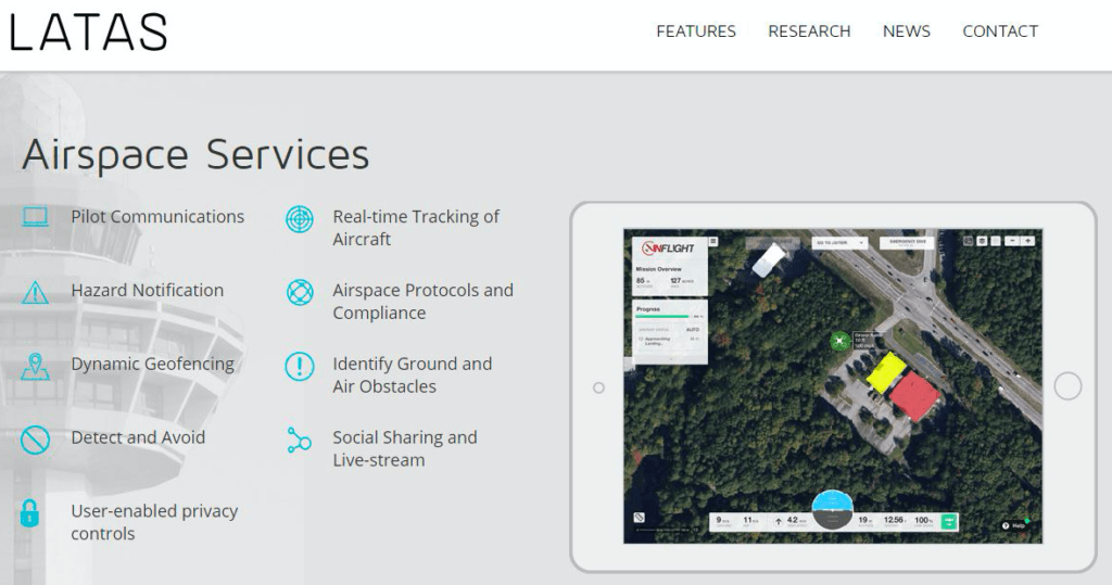
PrecisionHawk’s LATAS delivers an innovative air traffic control system for drones, but it’s one of several that depends on the not-so-imminent success of all aircraft using ADS-B.
QuickTake
THE FACTS: This past week, the FAA granted PrecisionHawk a waiver from Part 107.31’s visual line of sight (VLOS) limitations, which gives them the ability to continue their research and to train those who want to offer these extended visual line of sight (EVLOS) flights as a service. The waiver was granted based on over a year’s worth of testing under the FAA Pathfinder program. Under Pathfinder Phase 1 research, PrecisionHawk determined that the extension in range offered by EVLOS operations supports a significant expansion in the area that each drone flight, possibly up to 12 times what is achievable within line of sight.
Click on the image for a larger view.
To do this, PrecisionHawk uses their airspace display technology called LATAS, which stands for Low-Altitude Tracking and Avoidance System. LATAS is an onboard system that connects airspace management technologies, such as sense and avoid, geo-fencing, and aircraft tracking, into a service package for commercial and recreational drone operators as well as regulators and air traffic controllers. Developed to be plug and play or integrated into a drone’s circuit during manufacturing, LATAS is small (3-in by 2-in by 1-in), light (Less than 100 grams) and operational on network speeds as low as 2G. While it is not required to receive an EVLOS waiver, LATAS plays a key role in PrecisionHawk’s own operations. The LATAS web application is a free tool available on www.flylatas.com and is intended to provide an extra layer of safety and protection operators flying under Part 107.
WHAT’S COOL AND WHAT’S NOT: As I’ve have noted in Market Impact of the FAA Small Drone Rule, the inability to fly EVLOS restricts some high-margin operations. This new ability allows a drone to improve its economic efficiency and cover acreage which is needed for a large percentage of agriculture fields, mining operations, and large infrastructure sites.
One problem we see with this type of system is it may not be reliable in remote areas. Even though cell network companies are working to extend their networks by partnering with rural carriers, everyone who uses cell phones knows about gaps in service that happen unexpectedly. These gaps could have much more serious consequences than a dropped call if they happen to a small drone.
Additionally, we see integration with the Harris ADS-B (Automatic Dependent Surveillance – Broadcast) network data as a good thing, but, as we have written about in our in-depth research study ADS-B and Its Use for Small Drone Traffic Management, the FAA’s NextGen mandate for ADS-B has inherent limitations. For one, use of ADS-B “Out” (the signal that says “here I am”) is not required in Class G airspace where most small drones fly, and two, the FAA did not mandate ADS-B “In” (the ability to see other traffic). These together are killers for its effectiveness. Aircraft (including drones) can push all the “Out” signals they want, but if other aircraft can’t receive or “see” them, then they don’t know where your aircraft is and no avionics system can overcome that.
THE COMPETITION: PrecisionHawk is not alone in their endeavor, and we’re beginning to see others create ADS-B based solutions for drones.
For example in July 2016, DJI and uAvionix announced the release of an ADS-B collision avoidance developer kit. The uAvionix “Ping” sensors are among the smallest and lightest ADS-B-based hardware available for unmanned aircraft. Their Ping ADS-B receiver allows a drone to “see” surrounding aircraft and initiate collision avoidance maneuvers based on that information.
Sagetech has created a family of transponders ideal for the size, weight, and power requirements of unmanned systems applications. Their XP transponder data can be output via RS-232 serial communications to a wide range of compatible flight computers.
Other drone traffic management paradigms have been proposed – for example Google’s SkyBender and Amazon’s “Good, Better, Best”. I could go on, but you get the point. The pot is beginning to boil.
BOTTOM LINE: The current FAA plan emphasizes using small UAS in areas outside airport locations which should be geo-fenced to avoid drones interfering with large vehicle landing and take-off activities. But for all these drone traffic management plans, ADS-B technology (or ADS-B-like signal integration) is a key element for tracking and reporting a drone’s position.
NASA knows that someday unmanned vehicles will share airspace at low altitudes with general aviation equipment such as airplanes, helicopters, and gliders. That is why it created the Unmanned Aircraft System (UAS) Traffic Management (UTM) initiative. Agreeing on a safe and efficient system that will manage both manned and unmanned traffic is a vital concern for the FAA, NASA, private companies, and academic users.
But given the inherent limitations of ADS-B, will any of these systems work as intended?
 Colin Snow is CEO and Founder of Skylogic Research, LLC (aka Drone Analyst®), a research, content, and advisory services firm for the commercial drone industry. Colin is a 25-year technology industry veteran with a background in market research, enterprise software, electronics, digital imaging, and mobility.
Alan is serial entrepreneur, active angel investor, and a drone enthusiast. He co-founded DRONELIFE.com to address the emerging commercial market for drones and drone technology. Prior to DRONELIFE.com, Alan co-founded Where.com, ThinkingScreen Media, and Nurse.com. Recently, Alan has co-founded Crowditz.com, a leader in Equity Crowdfunding Data, Analytics, and Insights. Alan can be reached at alan(at)dronelife.com


Great article on small drones using LATAS technology and what’s coming in the future.