• Skip to main content
  • Skip to secondary menu
  • Skip to primary sidebar
  • Skip to secondary sidebar
  • Skip to footer
  • DroneRacingLife
  • DroneFlyers
  • Newsletter
DroneLife

DRONELIFE

Stay up to date on all the latest Drone News

  • News
  • Products
  • Industries
    • Agriculture
    • Construction
    • Delivery
    • Dual Use
    • Inspection
    • Public Safety
    • Surveying
  • Enthusiasts
  • Regulations
  • Business
  • Video
  • Podcasts

US Gov Partners with DJI, Drone Industry

July 26, 2016 by Miriam McNabb Leave a Comment

Photo: Bureau of Land Management

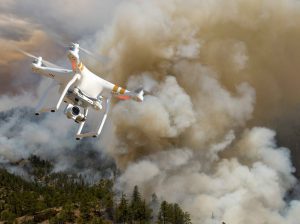
The US Department of the Interior has announced a collaboration with industry partners DJI, AirMap, and Skyward in an attempt to keep drones away from wildfires.

In an announcement yesterday, the US Department of the Interior (DOI) says that they have released a prototype warning system with industry partners to provide real-time alerts and geofencing alarms to drone operators, in order to prevent them from flying near wildfires.

“This pilot project makes initial wildfire location data publicly available to commercial mapping providers that support UAS operations, alerting drone pilots before they enter air space over an active wildland fire,” said Mark Bathrick, the director of Interior’s Office of Aviation Services. “No responsible drone operator wants to endanger the lives of the men and women who work to protect them and we believe this program, which uses the global positioning system to create a virtual barrier, will move us one step closer to eliminating this problem for wildfire managers.”

The system was developed with DJI, the world’s largest drone manufacturer, and AirMap and Skyward, leading providers of “airspace intelligence” for drones. AirMap and Skyward are now integrated with the DOI’s Integrated Reporting Wildland-Fire Information (IRWIN) program, and can immediately pass data to drone operators through AirMap’s iOS and web apps, AirMap’s API, and the GEO geofencing system, part of the DJI GO flight control app. DJI announced earlier this month that the GO app would include improved data on changing situations such as wildfires.

“Privately flown drones pose serious risks to firefighting planes and helicopters because these support aircraft fly low and slow, in smoke-obstructed areas, and their pilots are preoccupied with positioning to release water or fire retardant,” says the DOI announcement. “When drones enter air space over or near wildland fires, they force managers to either delay or cease aerial suppression operations, impeding efforts to control and contain these destructive blazes and placing firefighters and the communities they protect in greater danger.”

Drones near wildfires have been big news in recent months, as firefighters repeatedly complained of drones.  In Utah, the governor has responded by passing new legislation increasing the penalties for flying near fires or impeding firefighters; and has made it legal for authorities to down a drone sighted in an unauthorized area.

Geofencing has been used for some time to inform operators of restrictions around other sensitive areas like airports and prisons.  DOI says that they hope to expand the program before next year: “Experience and data obtained from this year’s prototype will be used to inform a full public and industry release planned for the 2017 fire season. In the future, the system will have the capability to prevent drones from operating in restricted airspace once they reach a geofence perimeter.”


Miriam McNabb

Miriam McNabb is the Editor-in-Chief of DRONELIFE and CEO of JobForDrones, a professional drone services marketplace, and a fascinated observer of the emerging drone industry and the regulatory environment for drones. Miriam has penned over 3,000 articles focused on the commercial drone space and is an international speaker and recognized figure in the industry.  Miriam has a degree from the University of Chicago and over 20 years of experience in high tech sales and marketing for new technologies.
For drone industry consulting or writing, Email Miriam.

TWITTER:@spaldingbarker

Subscribe to DroneLife here.

Filed Under: Legal Tagged With: AirMap, Department of the Interior, DJI, DJI GO, drones and wildfires, FAA, US Forest Service, Wildfires

Reader Interactions

Leave a Reply Cancel reply

Your email address will not be published. Required fields are marked *

Primary Sidebar

LATEST

Volocopter Unveils VoloXPro and Expands into Pilot Training Market, Air Sports

New ultralight multicopter targets private pilots, training organizations, and future air taxi operators Volocopter has introduced the VoloXPro, a new…

Continue Reading Volocopter Unveils VoloXPro and Expands into Pilot Training Market, Air Sports

Matternet Launches NHS Drone Deliveries in Central London

New service connects major hospital campuses to move critical medical items in minutes Matternet has launched drone delivery operations for…

Continue Reading Matternet Launches NHS Drone Deliveries in Central London

As Drone Delivery Expands, Communities Remain Uncertain

County denies Walmart bid to start drone deliveries By DRONELIFE Features Editor Jim Magill A board of Georgia county officials…

Continue Reading As Drone Delivery Expands, Communities Remain Uncertain

Rogue Drone Detected. Now What?

SkySafe and Motorola Solutions integration highlights the next step in managing low-altitude airspace At the Motorola Solutions Summit 2026 this…

Continue Reading Rogue Drone Detected. Now What?

New DJI Drones Launch Globally, But Not in the U.S.

Court filing highlights FCC restrictions as new products debut without U.S. availability Drone giant DJI has introduced new consumer drones,…

Continue Reading New DJI Drones Launch Globally, But Not in the U.S.

NYC Tests Cargo Drones to Cut Traffic and Speed Medical Deliveries

Port Authority Launches Yearlong Cargo Drone Trial Over East River. Skyports partnership aims to test middle-mile delivery, reduce congestion, and…

Continue Reading NYC Tests Cargo Drones to Cut Traffic and Speed Medical Deliveries

AirData and BRINC Integration Brings Automated Flight Records to Public Safety Drone Programs

New integration captures flight data automatically, supporting scalable and auditable drone operations AirData has announced a new integration with BRINC,…

Continue Reading AirData and BRINC Integration Brings Automated Flight Records to Public Safety Drone Programs

Sentrycs Lands Major Counter-Drone Contracts Across World Cup Cities

Sentrycs systems to protect skies in U.S., Mexico, Canada By DRONELIFE Features Editor Jim Magill (Editor’s note: This is part…

Continue Reading Sentrycs Lands Major Counter-Drone Contracts Across World Cup Cities

Kraus Hamdani Aerospace Demonstrates Wireless Power Beaming to K1000ULE at Shaw AFB

Kraus Hamdani Aerospace and PowerLight Technologies sustain the K1000ULE in flight using laser-based wireless power beaming, maintaining continuous ISR operations…

Continue Reading Kraus Hamdani Aerospace Demonstrates Wireless Power Beaming to K1000ULE at Shaw AFB

Sion Power Launches Two High Energy Density Batteries for Military Drones

Sion Power’s Licerion Strike and Echo cells exceed 500 Wh/kg, enabling combat drones to fly two to three times longer…

Continue Reading Sion Power Launches Two High Energy Density Batteries for Military Drones

Secondary Sidebar

Footer

SPONSORED

Inspired Flight Gremsy IF800 VIO F1 drones geo week

What Will It Take to Strengthen U.S. Drone Manufacturing? A Conversation with Inspired Flight’s CEO

Global Mapper Mobile data collection

Collection Ground Control Points with Global Mapper Mobile

Military Drone Mapping Solutions

How SimActive’s Correlator3D™ is Revolutionizing Military Mapping: An Exclusive Interview with CEO Philippe Simard

Photogrammetry Accuracy Standards

SimActive Photogrammetry Software: Enabling Users to Meet Accuracy Standards for Over 20 Years

NACT Engineering Parrot ANAFI tether indoor shot

Smart Tether for Parrot ANAFI USA from NACT Engineering

Blue Marble, features global mapper, features Blue Marble

Check Out These New Features in Global Mapper v25 from Blue Marble

About Us | Contact Us | Advertise With Us | Write for Us | Privacy Policy | Terms of Service

The Trusted Source for the Business of Drones.

This website uses cookies and third party services. By clicking OK, you are agreeing to our privacy policy. ACCEPT

Manage consent

Privacy Overview

This website uses cookies to improve your experience while you navigate through the website. Out of these, the cookies that are categorized as necessary are stored on your browser as they are essential for the working of basic functionalities of the website. We also use third-party cookies that help us analyze and understand how you use this website. These cookies will be stored in your browser only with your consent. You also have the option to opt-out of these cookies. But opting out of some of these cookies may affect your browsing experience.
Necessary
Always Enabled
Necessary cookies are absolutely essential for the website to function properly. These cookies ensure basic functionalities and security features of the website, anonymously.
CookieDurationDescription
cookielawinfo-checkbox-analytics11 monthsThis cookie is set by GDPR Cookie Consent plugin. The cookie is used to store the user consent for the cookies in the category "Analytics".
cookielawinfo-checkbox-functional11 monthsThe cookie is set by GDPR cookie consent to record the user consent for the cookies in the category "Functional".
cookielawinfo-checkbox-necessary11 monthsThis cookie is set by GDPR Cookie Consent plugin. The cookies is used to store the user consent for the cookies in the category "Necessary".
cookielawinfo-checkbox-others11 monthsThis cookie is set by GDPR Cookie Consent plugin. The cookie is used to store the user consent for the cookies in the category "Other.
cookielawinfo-checkbox-performance11 monthsThis cookie is set by GDPR Cookie Consent plugin. The cookie is used to store the user consent for the cookies in the category "Performance".
viewed_cookie_policy11 monthsThe cookie is set by the GDPR Cookie Consent plugin and is used to store whether or not user has consented to the use of cookies. It does not store any personal data.
Functional
Functional cookies help to perform certain functionalities like sharing the content of the website on social media platforms, collect feedbacks, and other third-party features.
Performance
Performance cookies are used to understand and analyze the key performance indexes of the website which helps in delivering a better user experience for the visitors.
Analytics
Analytical cookies are used to understand how visitors interact with the website. These cookies help provide information on metrics the number of visitors, bounce rate, traffic source, etc.
Advertisement
Advertisement cookies are used to provide visitors with relevant ads and marketing campaigns. These cookies track visitors across websites and collect information to provide customized ads.
Others
Other uncategorized cookies are those that are being analyzed and have not been classified into a category as yet.
SAVE & ACCEPT