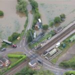
A Multi-Agency Approach to Disaster Management: From Flooding to Infrastructure Failures, Lincolnshire Resilience Forum Leverages Esri UK’s Real-Time Mapping Dashboard for Rapid Decision-Making and Community Resilience by DRONELIFE Staff Writer Ian J. McNabb The Lincolnshire Resilience Forum (LRF) recently adopted new technology from geospatial services firm Esri UK to … [Read more...] about Harnessing Geospatial Technology for Enhanced Emergency Response in Lincolnshire
Lincolnshire
Watch: UK Police Use Drone to Catch Deer Poachers
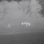
The UK is famous for many things but an abundance of exotic wildlife isn't one of them. Which means the police have to take special measures to keep what little they do have intact. Lincolnshire Police have a fleet of drones to help with event security, tactical operations and more. Over the weekend one was deployed above woods in Beckingham, Lincolnshire. Its heat-detecting … [Read more...] about Watch: UK Police Use Drone to Catch Deer Poachers


