
New update delivers user-driven interface improvements, expanded visualization tools, and enhanced file format support. Blue Marble Geographics has announced the release of Global Mapper® v26.2, the latest version of its all-in-one GIS software. The update was introduced this week at Intergeo 2025, the international mapping conference taking place in Frankfurt, Germany this … [Read more...] about Blue Marble Geographics Unveils Global Mapper® v26.2 at Intergeo 2025
LIDAR
India’s IdeaForge Integrates Inertial Lab’s LiDAR into Commercial UAV Solutions
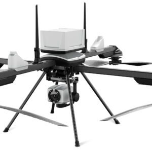
New Partnership Enhances UAV Mapping Capabilities ideaForge Technology Limited, an India-based global drone technology company, has announced a new partnership with Inertial Labs, a global leader in inertial sensors and GPS systems. This collaboration integrates Inertial Labs' RESEPI LiDAR solution into ideaForge's high-performance unmanned aerial vehicles (UAVs), representing … [Read more...] about India’s IdeaForge Integrates Inertial Lab’s LiDAR into Commercial UAV Solutions
The LiDAR Pros: Comprehensive LiDAR Drone Services from the Experts of Sundance Media Group
LiDAR Pros Expands Services and Drone Reselling in Southwest Region The integration of LiDAR technology into commercial drone operations continues to revolutionize industries such as architecture, surveying, construction, and public safety. The precision and efficiency offered by LiDAR have prompted significant advancements in data collection, enabling companies to … [Read more...] about The LiDAR Pros: Comprehensive LiDAR Drone Services from the Experts of Sundance Media Group
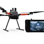
Wingtra Introduces Advanced LIDAR Drone Solution for Precision Mapping
Wingtra Unveils LIDAR Drone Solution, Transforming Aerial Mapping Wingtra is a leading drone technology company specializing in the development and manufacturing of high-end drone solutions. Today, Wingtra has announced the launch of its groundbreaking LIDAR drone solution, marking a significant leap forward in drone-based LIDAR technology. The new Wingtra LIDAR … [Read more...] about Wingtra Introduces Advanced LIDAR Drone Solution for Precision Mapping
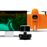
The Art and Science of Low-Light Drone Operations: LiDAR or Camera? A DRONELIFE Exclusive from Immervision

Immervision is a leading provider of "Deep Seeing Technology": wide-angle optics, processing, and sensor fusion for next generation technology. Here, Immervision AVP Ludimila Centano gives a deep dive on the sensor options available for safe, low-light drone operations. Read on to understand the pros and cons of low-light cameras vs. LiDAR sensors, what actually qualifies as … [Read more...] about The Art and Science of Low-Light Drone Operations: LiDAR or Camera? A DRONELIFE Exclusive from Immervision


