
New AI tool delivers accurate jobsite updates in minutes, saving time and reducing risk DroneDeploy Introduces AI-Powered Construction Progress Tool DroneDeploy has announced the launch of Progress AI, an artificial intelligence tool that automates construction progress tracking from drone and 360-degree camera data. Designed to replace time-consuming manual updates, Progress … [Read more...] about DroneDeploy Launches Progress AI to Automate Construction Tracking
drone data
Last Chance to Share Your Voice: Drone Industry Survey Extended

DRONEII extends global survey to capture more insights from drone professionals worldwide Drone Industry Insights (DRONEII) has announced a two-week extension of its Global Drone Industry Survey, giving drone professionals another opportunity to contribute valuable insights about the state of the industry. The annual DRONEII survey is one of the most comprehensive studies … [Read more...] about Last Chance to Share Your Voice: Drone Industry Survey Extended
Unleash live Secures A$17 Million to Expand AI-Powered Infrastructure Solutions Globally

The real-time video analytics platform will use Series B funding to grow operations and enhance AI innovation across key sectors Unleash live Raises A$17 Million to Fuel Global Growth Unleash live, an Australian-based company known for its AI-powered real-time video analytics platform, has announced the successful close of its Series B funding round. The company raised A$17 … [Read more...] about Unleash live Secures A$17 Million to Expand AI-Powered Infrastructure Solutions Globally
Wingtra Unveils WingtraGROUND: A Seamless Ground Control Solution for Drone Surveying
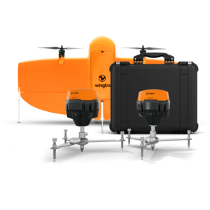
New all-in-one system integrates drone, field setup, and processing to simplify high-accuracy aerial mapping for surveyors of all experience levels. by DRONELIFE Staff Writer Ian J. McNabb Zurich, Switzerland-based drone developers Wingtra recently announced their new WingtraGROUND system, a new ground-control solution designed for the surveying space that combines “drone, … [Read more...] about Wingtra Unveils WingtraGROUND: A Seamless Ground Control Solution for Drone Surveying
India Launches Major Initiative to Share Geospatial Information Across Sectors
Operation DRONAGIRI leverages drones and geospatial technology to improve decision-making and foster innovation. India has launched Operation DRONAGIRI, a groundbreaking pilot project under the National Geospatial Policy 2022. The initiative aims to enhance collaboration and innovation across industries by integrating geospatial data and technology. Sectors like agriculture, … [Read more...] about India Launches Major Initiative to Share Geospatial Information Across Sectors


