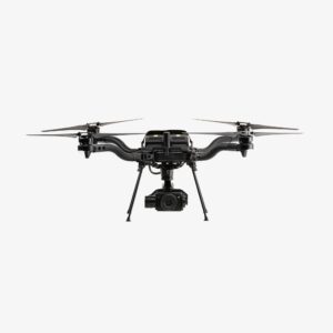
Freefly Systems' Astro Max Becomes First NDAA-Compliant Drone in Esri's Geospatial Application Esri has announced support for the Astro Max drone in its ArcGIS Flight application. The Astro Max, developed by Freefly Systems, is the first Blue UAS cleared and NDAA-compliant drone to integrate with the geospatial software1. Enhanced Capabilities for Government and Enterprise … [Read more...] about Esri Integrates Blue UAS Cleared Drone with ArcGIS Flight
- Skip to main content
- Skip to secondary menu
- Skip to primary sidebar
- Skip to secondary sidebar
- Skip to footer
DRONELIFE
Stay up to date on all the latest Drone News


