
On the second day of the DroneDeploy conference in Denver, an enterprise panel discussed what automation means on the jobsite - capturing data with automated drones, ground robots, and more. Continue reading below, or listen: DroneLife · Automated - Drones - Ground - Robots - For - Reality - CaptureThis year's DroneDeploy conference has been exciting - not only is the … [Read more...] about Automating Reality Capture on Job Sites with Drones, Ground Robots, and More: Users Perspective
Data analytics
Check Out These New Features in Global Mapper v25 from Blue Marble
Top New Features in Global Mapper v25 Continue reading below, or listen: DroneLife · Blue - Marble - New - Features - Global - Mapper - Pro Blue Marble Geographic’s flagship software, Global Mapper Pro, is an all-in-one GIS package for analyzing and processing vector, terrain, image, and point cloud data. A comprehensive and easy-to-use GIS application that provides an … [Read more...] about Check Out These New Features in Global Mapper v25 from Blue Marble
Drone Data Analysis and Asset Inspection: Pointivo’s Dan Ciprari on Why He Invested in Drone Tech, and What’s Next for the Industry
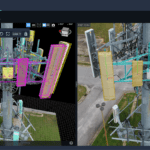
Dan Ciprari is CEO of Pointivo, the company providing the algorithms and technology behind some of the largest in-house drone-based asset inspection programs in the country. As Pointivo expands their portfolio to include complete products sold under their own label, the Pointivo name is becoming more prevalent in asset inspection and data analytics. DRONELIFE had the … [Read more...] about Drone Data Analysis and Asset Inspection: Pointivo’s Dan Ciprari on Why He Invested in Drone Tech, and What’s Next for the Industry
Improving Drone Data Capture: Visual Intelligence Partners with Gimbal Manufacturer Gremsy
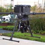
Visual Intelligence Partners with Gremsy for Drone Data Capture by DRONELIFE Staff Writer Ian M. Crosby Drone sensor and software automation platform Visual Intelligence and drone camera gimbal stabilizer manufacturer Gremsy have announced a partnership for the production of a multiple-axis gimbal able to carry a multiple-camera array for vertical data collection. Continue … [Read more...] about Improving Drone Data Capture: Visual Intelligence Partners with Gimbal Manufacturer Gremsy
From the floor of Intergeo: Simactive, Mapping Spaces from Countries to Construction Sites

INTERGEO, held this week in Essen, Germany, is positioning itself as the leading global platform for GIS IT. INTERAERIAL Solutions is the section of the show featuring drone solutions: an increasingly important sector of the GIS industry. Many mapping service providers work in one arena or the other: using satellite or data acquired from large manned aircraft to map large … [Read more...] about From the floor of Intergeo: Simactive, Mapping Spaces from Countries to Construction Sites


