
Measure's inspection services business has been acquired by Asia Pacific company Aerodyne, forming a new joint venture entity - Aerodyne Measure - for drone services. Measure will continue to operate independently as an enterprise software provider: Measure CEO Brandan Declet Torres comments that the partnership will significantly expand the user base of Measure Ground … [Read more...] about Aerodyne Acquires Measure’s Inspection Services Business
Telecommunications
Drone Mapping: A Podcast with Jono Millin of DroneDeploy
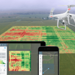
Learn more about drone mapping and drone mapping software in this CommercialDrones.fm podcast with Jono Millin, one of the founders of DroneDeploy, as he speaks with drone expert and host Ian Smith. "Jono Millin is co-founder and Chief Customer Officer (CCO) at DroneDeploy, a software company that specializes in building solutions for mapping business assets with drones. … [Read more...] about Drone Mapping: A Podcast with Jono Millin of DroneDeploy
Drone Harmony Launches Data Capture Platform for Drone Service Providers
Swiss startup Drone Harmony has launched a data capture platform for drone service providers and enterprise customers, which will work in tandem with its established flight planning tools. Drone Harmony users can now count on cloud storage of mission data and a web-based flight planning interface that can be used alongside the company's existing mobile app. Automated … [Read more...] about Drone Harmony Launches Data Capture Platform for Drone Service Providers
Don’t Fly Blind: The Business of Air Traffic Awareness for Drones

UTM, air traffic awareness, remote ID and tracking, and collision avoidance are all hot topics in the drone industry. As these frameworks and technologies develop, risks will decrease, regulations will ease, and the applications that commercial drones are regularly able to perform will expand dramatically. There is always, however, more than one way to skin the proverbial … [Read more...] about Don’t Fly Blind: The Business of Air Traffic Awareness for Drones
Optelos + DroneDeploy Together at DistribuTECH: From Drone Mapping to AI Image Intelligence

Two leading drone data software solutions are joining forces at DistribuTECH this week to show utility professionals and commercial drone operators a complete workflow system - delivering world class drone maps with context and AI-driven image intelligence. DistribuTECH is the utility and energy industry's leading technology conference. It's a growing vertical for the drone … [Read more...] about Optelos + DroneDeploy Together at DistribuTECH: From Drone Mapping to AI Image Intelligence


