• Skip to main content
  • Skip to secondary menu
  • Skip to primary sidebar
  • Skip to secondary sidebar
  • Skip to footer
  • DroneRacingLife
  • DroneFlyers
  • Newsletter
DroneLife

DRONELIFE

Stay up to date on all the latest Drone News

  • News
  • Products
  • Industries
    • Agriculture
    • Construction
    • Delivery
    • Dual Use
    • Inspection
    • Public Safety
    • Surveying
  • Enthusiasts
  • Regulations
  • Business
  • Video
  • Podcasts

DJI Announces New Zenmuse L2 Drone LiDAR: From the Floor of Intergeo

October 10, 2023 by Harry McNabb 4 Comments

DJI drone LiDARToday, at the InterGeo Show in Berlin, DJI Enterprise featured their new Zenmuse L2 drone Lidar: expanded range, even more accuracy.

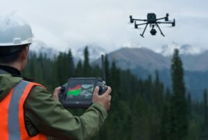
In a session led by DJI Solution Engineer Kyle Miller, the L2 was on display.  With a lot of improvements over the L1, the L2 ups the game for professionals in a wide range of survey use cases.  The L2 provides more flexibility, and offers a faster, more precise result.

“[It’s been] 2-1/2 years since the release of L1, and we are pleased to announce the Zenmuse L2,” said Miller.  “You can fly higher, faster, and more accurately than the L1.”

The L2 drone LiDAR offers some significant improvements for applications in construction and surveying: a 30% increase in detection range, denser point clouds, and more coverage in heavy vegetation.

Increased Detection Range, More Precision

The newest version of DJI’s drone-based LiDAR offers a whopping 30% increase of detection range over the previous model.  The company website says: “L2 can detect from 250 meters at 10% reflectivity and 100 klx, and up to 450 meters at 50% reflectivity and 0 klx. The typical operational altitude now extends up to 120 meters, notably enhancing operational safety and efficiency.”

With smaller points, the L2 can detect smaller objects and provide better detail and more accurate digital elevation models. In addition, the L2 imoves from 3 returns to 5 returns: “More passes give you a better point cloud,” Miller explains.  The result is more ground points captured beneath the foliage.  “If you’re working in forestry, the L2 does a supreme job,” Miller said.

With two scanning modes, frame-based design, and a better user experience, the L2 offers a complete solution and a complementary tool for commercial users in infrastructure management, forestry, land survey, and power.  Drone LiDAR,  isn’t designed to compete with manned aircraft: “but in many cases can act to fill in the gaps in the data,” Miller points out.

Read more:

  • The New DJI Mini 4: Here’s What the Reviewers are Saying (and Why)
  • DJI Launches Air 3 Drone: Dual Cameras, Omnidirectional Obstacle Sensing
  • DJI Matrice M30, Matrice M350 RTK Earn EU Certifications
  • DJI’s New Commercial Drone: Matrice 350 RTK is More Resilient, More Flexible, More Efficient
  • Choosing a LiDAR Sensor: What They Are, What They Do


Harry McNabb
Harry McNabb

CEO DroneLife.com, DroneRacingLife.com, and CMO of Jobfordrones.com. Principle at Spalding Barker Strategies. Has enjoyed working with and around the commercial drone industry for the last 10 years.   Attendance and speaker at Industry Events such as Commercial UAV, InterGeo, Interdrone and others.   Proud father of two. Enjoys karate, Sherlock Holmes, and interesting things.  Subscribe to all things drone at DroneLife here. Email is Harry@dronelife.com.   Make Sure that you WhiteList us in your email to make sure you get our Newsletter.  Editor1@dronelife.com.

Filed Under: DJI, Drone News, Drone News Feeds, Drones in the News, News, Uncategorized Tagged With: DJI, drone LiDAR, drone surveying, Zenmuse

Reader Interactions

Trackbacks

  1. INTERGEO 2023: Der Hightech-Gigant unter den Geo-Messen mit spannenden Oasen – Stadtkreation-Blog says:
    October 12, 2023 at 6:39 am

    […] ein paar inhaltliche und fotografische Eindrücke übermitteln zu können, unter anderem von der Zenmuse L2, dem aktuell fortschrittlichsten LiDAR-Modul des […]

    Reply
  2. DJI Announces New Zenmuse L2 Drone LiDAR: From the Floor of Intergeo – WELCOME ON Dronestag Blog says:
    October 11, 2023 at 12:49 am

    […] More… […]

    Reply
  3. DJI Announces New Zenmuse L2 Drone LiDAR: From the Floor of Intergeo | taktik(z) GDI (Government Defense Infrastructure) says:
    October 11, 2023 at 12:43 am

    […] post DJI Announces New Zenmuse L2 Drone LiDAR: From the Floor of Intergeo appeared first on […]

    Reply
  4. DJI Announces New Zenmuse L2 Drone LiDAR: From the Floor of Intergeo – Drone JI Air Works says:
    October 10, 2023 at 11:52 pm

    […] post DJI Announces New Zenmuse L2 Drone LiDAR: From the Floor of Intergeo appeared first on […]

    Reply

Leave a Reply Cancel reply

Your email address will not be published. Required fields are marked *

Primary Sidebar

LATEST

Teledyne FLIR OEM Upgrades Prism SKR Software for Autonomous Target Recognition

New release combines mission execution and intelligent supervision in a single autonomy platform Teledyne FLIR OEM has announced an upgrade…

Continue Reading Teledyne FLIR OEM Upgrades Prism SKR Software for Autonomous Target Recognition

Drone Operations Software Company AirHub Closes €4.4M Series A

AirHub, a European drone operations software company based in The Hague, has closed a €4.4 million Series A funding round.…

Continue Reading Drone Operations Software Company AirHub Closes €4.4M Series A

Arrive AI Patents Shared Drone Delivery Endpoint With Tenth U.S. Patent

Arrive AI (NASDAQ: ARAI) has secured its tenth U.S. patent, strengthening its intellectual property portfolio for autonomous drone delivery infrastructure.…

Continue Reading Arrive AI Patents Shared Drone Delivery Endpoint With Tenth U.S. Patent

Korean eVTOL Developer Airbility Partners on UAV Public Safety in Thailand

South Korean eVTOL developer Airbility has signed a four-party Memorandum of Understanding to deploy UAV systems for public safety and…

Continue Reading Korean eVTOL Developer Airbility Partners on UAV Public Safety in Thailand

Is U.S. Manufacturing the Answer? SKYROVER Signals a New Strategy as FCC Pressure Mounts

A Hong Kong-based drone company outlines a five-year U.S. roadmap, raising questions about compliance, supply chains, and market access A…

Continue Reading Is U.S. Manufacturing the Answer? SKYROVER Signals a New Strategy as FCC Pressure Mounts

Blue Marble Geographics and Avenza Systems Combine to Create Unified Geospatial Platform

Merger connects office-based analysis with field operations for end-to-end spatial workflows Blue Marble Geographics and Avenza Systems, Inc. have announced…

Continue Reading Blue Marble Geographics and Avenza Systems Combine to Create Unified Geospatial Platform

Amazon Prime Air Adjusts Course After Richardson Setbacks

After rocky start in Texas city, Amazon Air service flying high By DRONELIFE Features Editor Jim Magill After only a…

Continue Reading Amazon Prime Air Adjusts Course After Richardson Setbacks

Airspace Security at 2026 JUNO Awards

RF-Cyber counter-drone system enables non-disruptive protection for large public event D-Fend Solutions announced that its EnforceAir counter-drone system was deployed…

Continue Reading Airspace Security at 2026 JUNO Awards

Will States Be Ready with Counter Drone Tech for the FIFA World Cup?

Funding snafu, other issues delay counter-UAS ramp-up in Maryland, elsewhere By DRONELIFE Features Editor Jim Magill (Editor’s note: This is…

Continue Reading Will States Be Ready with Counter Drone Tech for the FIFA World Cup?

Strait of Hormuz Tensions Highlight a Growing Role for Small Drone Surveillance

Maritime risk, insurance pressure, and degraded navigation signals point to new use cases for commercial UAV systems Ongoing tension in…

Continue Reading Strait of Hormuz Tensions Highlight a Growing Role for Small Drone Surveillance

Secondary Sidebar

Footer

SPONSORED

Inspired Flight Gremsy IF800 VIO F1 drones geo week

What Will It Take to Strengthen U.S. Drone Manufacturing? A Conversation with Inspired Flight’s CEO

Global Mapper Mobile data collection

Collection Ground Control Points with Global Mapper Mobile

Military Drone Mapping Solutions

How SimActive’s Correlator3D™ is Revolutionizing Military Mapping: An Exclusive Interview with CEO Philippe Simard

Photogrammetry Accuracy Standards

SimActive Photogrammetry Software: Enabling Users to Meet Accuracy Standards for Over 20 Years

NACT Engineering Parrot ANAFI tether indoor shot

Smart Tether for Parrot ANAFI USA from NACT Engineering

Blue Marble, features global mapper, features Blue Marble

Check Out These New Features in Global Mapper v25 from Blue Marble

About Us | Contact Us | Advertise With Us | Write for Us | Privacy Policy | Terms of Service

The Trusted Source for the Business of Drones.

This website uses cookies and third party services. By clicking OK, you are agreeing to our privacy policy. ACCEPT

Manage consent

Privacy Overview

This website uses cookies to improve your experience while you navigate through the website. Out of these, the cookies that are categorized as necessary are stored on your browser as they are essential for the working of basic functionalities of the website. We also use third-party cookies that help us analyze and understand how you use this website. These cookies will be stored in your browser only with your consent. You also have the option to opt-out of these cookies. But opting out of some of these cookies may affect your browsing experience.
Necessary
Always Enabled
Necessary cookies are absolutely essential for the website to function properly. These cookies ensure basic functionalities and security features of the website, anonymously.
CookieDurationDescription
cookielawinfo-checkbox-analytics11 monthsThis cookie is set by GDPR Cookie Consent plugin. The cookie is used to store the user consent for the cookies in the category "Analytics".
cookielawinfo-checkbox-functional11 monthsThe cookie is set by GDPR cookie consent to record the user consent for the cookies in the category "Functional".
cookielawinfo-checkbox-necessary11 monthsThis cookie is set by GDPR Cookie Consent plugin. The cookies is used to store the user consent for the cookies in the category "Necessary".
cookielawinfo-checkbox-others11 monthsThis cookie is set by GDPR Cookie Consent plugin. The cookie is used to store the user consent for the cookies in the category "Other.
cookielawinfo-checkbox-performance11 monthsThis cookie is set by GDPR Cookie Consent plugin. The cookie is used to store the user consent for the cookies in the category "Performance".
viewed_cookie_policy11 monthsThe cookie is set by the GDPR Cookie Consent plugin and is used to store whether or not user has consented to the use of cookies. It does not store any personal data.
Functional
Functional cookies help to perform certain functionalities like sharing the content of the website on social media platforms, collect feedbacks, and other third-party features.
Performance
Performance cookies are used to understand and analyze the key performance indexes of the website which helps in delivering a better user experience for the visitors.
Analytics
Analytical cookies are used to understand how visitors interact with the website. These cookies help provide information on metrics the number of visitors, bounce rate, traffic source, etc.
Advertisement
Advertisement cookies are used to provide visitors with relevant ads and marketing campaigns. These cookies track visitors across websites and collect information to provide customized ads.
Others
Other uncategorized cookies are those that are being analyzed and have not been classified into a category as yet.
SAVE & ACCEPT