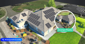
 Residential solar surveys are a great opportunity for commercial drone service providers. Here, an expert gives advice on getting the very best output.
The following is a guest post by Jason Steinberg, CEO of Scanifly: the only drone-based solar software committed to improving the efficiency, accuracy and safety of solar projects globally. DRONELIFE neither accepts nor makes payment for guest posts.
Most drone pilots are familiar with grid or lawn mower-shaped flight paths shot with nadir imagery. These patterns are easy to program – just set the perimeter, click the button, and go. But a residential rooftop solar project has more nuanced considerations, including the accuracy of the property and surrounding environment.
The additional nuances of residential rooftop solar lead to three key reasons why capturing oblique imagery is a more effective approach.
Nadir versus oblique
A nadir image is captured when the drone flies with the camera facing straight down or at a slight angle. These “nadir” images typically yield lower quality models because z-axis structures are less visible.
An oblique image is captured when the drone captures images at a side angle, displaying vertical and horizontal features of a property. Further, when done to maximize model quality, a drone will capture oblique images from different altitudes and perspectives.
1. More easily spot trees and other vegetation
Nadir images might spot trees or other vegetation on the property (as in, you’ll know they are there). But it is more difficult to model how big they are or how much they obstruct the roof. Oblique imagery, on the other hand, can easily spot how vegetation may impact a solar installation because you get a realistic impression of what the vegetation actually looks like in context and as it affects a sun’s path.
This matters a lot because poor vegetation recognition can incorrectly depict a solar shading analysis, which is critical for accurately modeling a solar project’s expected production. An incorrect forecast could leave the homeowner expecting a lot more than they ultimately receive. In that case, homeowners and contractors alike would be very unhappy.
2. Better detect small obstructions
Pointing a camera straight down negatively impacts detecting small obstructions, like vent pipes and attic fans, because the verticality of those objects aren’t effectively modelled. Missing obstructions in your modelling can derail a solar project by forcing a redesign, delaying an install, or negatively impacting customer expectations.
Oblique imagery will better present the X, Y, and Z-axes of a property, meaning you’ll more easily spot obstructions and can plan around them. This might mean a smaller installation, yet you can adjust customer expectations ahead of time to avoid problems on install day.
3. Increase sales using oblique images
Models created from nadir images lack real-world features. Often facades can look melted and the sides of structures blurred. Or worse, a nadir image misses data and yields holes in a model reconstruction. Oblique imagery, on the other hand, can yield truly comprehensive, interactive 3D models. Not only does this help solar designers get more context about the site, the images can be used for marketing and showing customers what the finished project will look like. These to-scale, virtual replica models are sometimes so good that they look like photos of real homes.
Don’t lose on bad data
Installing a solar project is like putting a mini-power plant on your roof. It’s best practice to capture the most thorough details possible. Thankfully, multiple drones (like DJI’s Mavic Pro or Phantom Series, Autel’s flagship drone, and Skydio) now make it much easier to automatically capture oblique imagery. This enables accuracy to within 2-3 inches and clarity to streamline and automate much of a solar project’s workflow.
Read more from Jason at Scanifly in this piece on flying a drone in challenging conditions, and combining the best technologies for the best in 3D modeling.

Jason Steinberg is the CEO of Scanifly and oversees the operational and financial aspects of the company. Scanifly is the only drone-based solar software committed to improving the efficiency, accuracy and safety of solar projects globally. Previously, Jason helped finance over $3 billion of renewable energy projects and companies as a banker for CohnReznick Capital. Prior to that, Jason worked for Bloomberg New Energy Finance as a lead North American data researcher. Jason’s first job in the industry was installing solar arrays on rooftops in New Jersey. Jason is a FAA Part 107, CFA Charterholder and a NABCEP PV Associate.

Miriam McNabb is the Editor-in-Chief of DRONELIFE and CEO of JobForDrones, a professional drone services marketplace, and a fascinated observer of the emerging drone industry and the regulatory environment for drones. Miriam has penned over 3,000 articles focused on the commercial drone space and is an international speaker and recognized figure in the industry. Miriam has a degree from the University of Chicago and over 20 years of experience in high tech sales and marketing for new technologies.
For drone industry consulting or writing, Email Miriam.
TWITTER:@spaldingbarker
Subscribe to DroneLife here.


[…] post Residential Solar Surveys with Drones: Why You Should Always Include Oblique Imagery appeared first on […]