• Skip to main content
  • Skip to secondary menu
  • Skip to primary sidebar
  • Skip to secondary sidebar
  • Skip to footer
  • DroneRacingLife
  • DroneFlyers
  • Newsletter
DroneLife

DRONELIFE

Stay up to date on all the latest Drone News

  • News
  • Products
  • Industries
    • Agriculture
    • Construction
    • Delivery
    • Dual Use
    • Inspection
    • Public Safety
    • Surveying
  • Enthusiasts
  • Regulations
  • Business
  • Video
  • Podcasts

Wildfire Meteorology: Drones Provide a Better, Cheaper Way to Understand Fire Risk

November 11, 2020 by Miriam McNabb 6 Comments

image courtesy Fire Weather Research Laboratory, San Jose State University

Drones becoming a useful tool in wildfire meteorology, the effort to understand weather that leads to fire risk.

By DRONELIFE Staff Writer Jim Magill

As wildfires continue to rage across vast swaths of the western United States, researchers are developing the use of unmanned aerial vehicles (UAVs) to understand the weather systems that lead to the fires’ ignition and spread and to help develop tools to battle the blazes.

A team of researchers from the Fire Weather Research Laboratory at San Jose State University in California recently completed a study that demonstrated that a drone equipped with a sonic anemometer is an effective tool for taking vertical profiles of atmospheric variables, a process that would otherwise require the use of costly weather balloons or the construction of a meteorological tower.

What is Wildfire Meteorology?

“It tuns out the wildfire environment is poorly sampled and there have not been a lot of measurements around wildfires,” Craig Clements, professor at SJSU’s Fire Research Laboratory and leader of the project, said in an interview. “We need that data to better understand the fire environment for modeling so we can better predict changes, especially as the climate changes and fires get more intense.”

Clements began experimenting with using unmanned aircraft to measure meteorological conditions near wildfires in 2008, when he flew a small fixed-wing, gas-powered remote-controlled airplane through the smoke plumes of wildfires. Since then, the increasing sophistication of UAVs has greatly expanded the potential for their use in fire research, he said.

How Wildfire Meteorology with a Drone Works

image courtesy Fire Weather Research Laboratory, San Jose State University

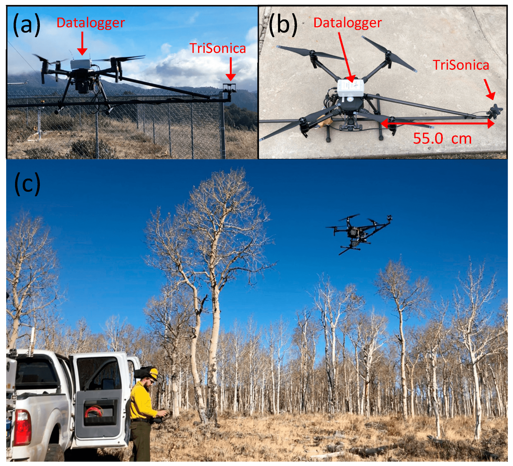
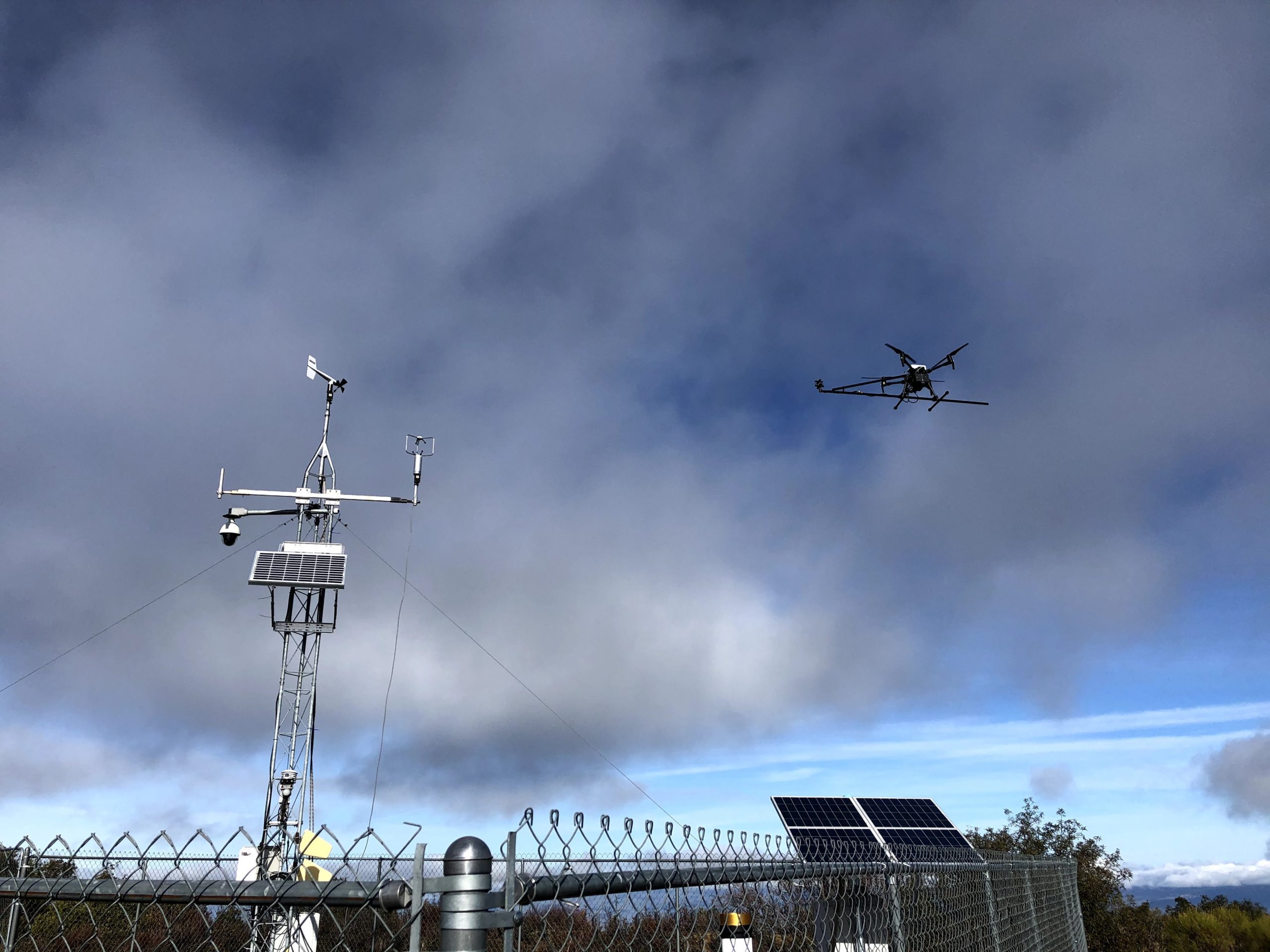
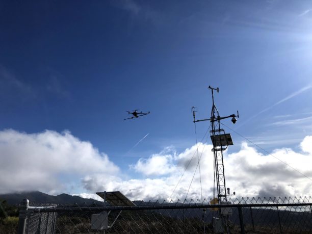
Working in collaboration with U.S. Forest Service and the Desert Research Institute (DRI), the San Jose research team used a DJI Matrice 200 (M200) equipped with a TriSonica™ Mini Wind and Weather sensor, to sample the vertical wind profiles of three-dimensional winds generated by wildfires, according to a research paper.

Because the researchers wanted to measure vertical wind velocity, that had to position the sensor off to the side of the drone, to avoid having the prop wash from the drone’s rotors interfere with their measurements. The solution was to install a carbon-fiber boom, which positioned the sensor at a distance of about two times the propeller width away from the body of the UAV, to eliminate some of the influences of the prop wash.

The team used the anemometer with its data monitor powered through the USB port on the drone itself, said Matthew Brewer, a former graduate research assistant in the Fire Weather Research Laboratory.

Following a series of test flights, the team was ready to take the drone out for a test flight near a controlled fire in Fishlake National Forest, Utah, in November 2019. Unfortunately, the team was unable to fly close to a fire as they had hoped, when the organizers of the controlled burn decided to ignite the fire from a helicopter.

“Once there’s a helicopter in the air, then you really can’t fly a drone,” Clements said. “So, we had to do our flight before the helicopter ignition took place.”

Although the researchers were not able to actually fly near a fire, they were able to take the UAV to the site and fly it, taking vertical profiles of the atmosphere, which gave them two soundings, Brewer said. Because he was operating the drone under an FAA Certificate of Authorization, which allowed for flights above the normal 400-foot limit, Brewer was able to take one measurement at 1,500 feet above ground level.

“It showed that this platform could be used for high-resolution atmospheric sounding,” he said. “We found that the UAS can measure winds reasonably well for certain applications, such as monitoring fires and getting rough soundings. But further work is needed.”

Clements said the research demonstrated that UAVs can be used as a platform to take atmospheric measurements in the vicinity of wildfires, with many advantages over more traditional meteorological- sensor platforms such as weather balloons. For example, the sensor package carried by a balloon is disposable and designed for only a single use.

“The weather balloon goes up to 50,000 feet and then they burst and the sensor drops back to earth and they’re not collected, he said. Because the use of a drone allows the researchers to retain the sensor reuse, the scientists can afford to use a more sophisticated, and expensive, sensor package than they would with a balloon.

The use of the drone platform “gives us a lot more flexibility,” Clements said. “We can fly it wherever we want. Over time it will save us money.”

The last consideration is particularly important as the use of weather balloons can become quite expensive, especially for a relatively small research entity like the SJSU Fire Weather Research Laboratory. “Every time you launch a weather balloon you have a $200 sensor, a $10 balloon and probably about $10 in helium. And helium costs are going up.”

wildfire meteorology
image courtesy Fire Weather Research Laboratory, San Jose State University

However, there are some limitations to the use of drones in wildfire meteorology, Clements said. One is vertical height, 1,500 feet for a drone, versus 50,000 feet for a weather balloon.

Another limitation with drones such as the Matrice 200 is because they are so small and lightweight, Clements said he is not sure that it could be flown directly above large-scale wildfires like those currently ravaging the West.

“I don’t think that many smaller drones could handle the extreme updraft associated with these fires,” he said. More likely researchers flying sensor-equipped drones would keep them away from the fire front, to take measurements in close proximity to the fire.

“If we were to take the drone to some smaller-scale grass fires, then we would fly the drone through the plume as we did in 2008,” he said.


Miriam McNabb

Miriam McNabb is the Editor-in-Chief of DRONELIFE and CEO of JobForDrones, a professional drone services marketplace, and a fascinated observer of the emerging drone industry and the regulatory environment for drones. Miriam has penned over 3,000 articles focused on the commercial drone space and is an international speaker and recognized figure in the industry.  Miriam has a degree from the University of Chicago and over 20 years of experience in high tech sales and marketing for new technologies.
For drone industry consulting or writing, Email Miriam.

TWITTER:@spaldingbarker

Subscribe to DroneLife here.

Filed Under: Conservation, DL Exclusive, Drone News Feeds, News Tagged With: Drones For Good, drones in firefighting, drones in meteorology, drones in public service, Public Safety Drones

Reader Interactions

Trackbacks

  1. Wildfire Meteorology Drones Offer New Tool - Go Drones Blog says:
    November 12, 2020 at 3:18 am

    […] Scientists at San Jose State University are using drones in wildfire meteorology, a way of understanding weather and wildfires. Source […]

    Reply
  2. Wildfire Meteorology Drones Offer New Tool - DRONELIFE - DroneLife - Drones News says:
    November 11, 2020 at 10:52 pm

    […] Clements began experimenting with using unmanned aircraft to measure meteorological conditions near wildfires in 2008, when heSource… […]

    Reply
  3. Wildfire Meteorology: Drones Provide a Better, Cheaper Way to Understand Fire Risk - Drone Market says:
    November 11, 2020 at 1:03 pm

    […] Source […]

    Reply
  4. Wildfire Meteorology: Drones Provide a Better, Cheaper Way to Understand Fire Risk - Eledonk Electronics says:
    November 11, 2020 at 12:55 pm

    […] post Wildfire Meteorology: Drones Provide a Better, Cheaper Way to Understand Fire Risk appeared first on […]

    Reply
  5. Wildfire Meteorology: Drones Provide a Better, Cheaper Way to Understand Fire Risk | Drone Magazine says:
    November 11, 2020 at 12:47 pm

    […] Source […]

    Reply
  6. Wildfire Meteorology: Drones Provide a Better, Cheaper Way to Understand Fire Risk – DronePilots.News says:
    November 11, 2020 at 12:38 pm

    […] post Wildfire Meteorology: Drones Provide a Better, Cheaper Way to Understand Fire Risk appeared first on […]

    Reply

Leave a Reply Cancel reply

Your email address will not be published. Required fields are marked *

Primary Sidebar

LATEST

From Missions to Management: The Shift Defining Public Safety Drone Programs [DRONELIFE Exclusive Interview]

As public safety drone use scales, data, compliance, and coordination define success Public safety drone programs have reached an inflection…

Continue Reading From Missions to Management: The Shift Defining Public Safety Drone Programs [DRONELIFE Exclusive Interview]

Can One Drone Safely Stop Another? Vector and Wrap Think So

Vector teams with Wrap to create killer-drone system By DRONELIFE Features Editor Jim Magill Vector, a Utah-based technology company that…

Continue Reading Can One Drone Safely Stop Another? Vector and Wrap Think So

American Drone Network and BRANDT Partner to Advance Agricultural Drone Spraying

Collaboration focuses on improving application efficiency, product performance, and pilot training American Drone Network (ADN) has announced a new partnership…

Continue Reading American Drone Network and BRANDT Partner to Advance Agricultural Drone Spraying

Honeywell and Odys Aviation Introduce Airborne Layer for Counter-UAS Defense

New system highlights the need for layered protection against evolving drone threats As drone threats continue to evolve, defense strategies…

Continue Reading Honeywell and Odys Aviation Introduce Airborne Layer for Counter-UAS Defense

The Real FCC Drone Debate: Who Controls the Airwaves?

A closer look at how spectrum policy and licensing could determine the future of U.S. drone operations The FCC is…

Continue Reading The Real FCC Drone Debate: Who Controls the Airwaves?

Why Japan’s AAM Roadmap May Be the Most Realistic in the World

A phased, system-wide approach focuses on operations, infrastructure, and public acceptance Japan’s leading AAM provider, SkyDrive, has translated the country’s…

Continue Reading Why Japan’s AAM Roadmap May Be the Most Realistic in the World

DroneShield Opens European Headquarters in Amsterdam Amid Growing Counter-Drone Demand

DroneShield has officially opened its new European headquarters in Amsterdam, The Netherlands. The move strengthens the counter-drone company’s operational presence…

Continue Reading DroneShield Opens European Headquarters in Amsterdam Amid Growing Counter-Drone Demand

Mid-America Transplant Opens 160-Mile Drone Corridor for Organ Donation

Mid-America Transplant has become the first organ procurement organization (OPO) in the United States to use drones for donor blood…

Continue Reading Mid-America Transplant Opens 160-Mile Drone Corridor for Organ Donation

Manna Raises $50M to Expand Drone Delivery Network in the U.S.

Funding supports plans for 40 new bases and continued scaling of suburban UAV delivery operations Manna Air Delivery has announced…

Continue Reading Manna Raises $50M to Expand Drone Delivery Network in the U.S.

Terra Drone Invests in Ukraine-Based Interceptor Drone Company, Launches Terra A1

Partnership aims to scale low-cost defense solutions and expand global unmanned systems capabilities Terra Drone Corporation has announced a strategic…

Continue Reading Terra Drone Invests in Ukraine-Based Interceptor Drone Company, Launches Terra A1

Secondary Sidebar

Footer

SPONSORED

Inspired Flight Gremsy IF800 VIO F1 drones geo week

What Will It Take to Strengthen U.S. Drone Manufacturing? A Conversation with Inspired Flight’s CEO

Global Mapper Mobile data collection

Collection Ground Control Points with Global Mapper Mobile

Military Drone Mapping Solutions

How SimActive’s Correlator3D™ is Revolutionizing Military Mapping: An Exclusive Interview with CEO Philippe Simard

Photogrammetry Accuracy Standards

SimActive Photogrammetry Software: Enabling Users to Meet Accuracy Standards for Over 20 Years

NACT Engineering Parrot ANAFI tether indoor shot

Smart Tether for Parrot ANAFI USA from NACT Engineering

Blue Marble, features global mapper, features Blue Marble

Check Out These New Features in Global Mapper v25 from Blue Marble

About Us | Contact Us | Advertise With Us | Write for Us | Privacy Policy | Terms of Service

The Trusted Source for the Business of Drones.

This website uses cookies and third party services. By clicking OK, you are agreeing to our privacy policy. ACCEPT

Manage consent

Privacy Overview

This website uses cookies to improve your experience while you navigate through the website. Out of these, the cookies that are categorized as necessary are stored on your browser as they are essential for the working of basic functionalities of the website. We also use third-party cookies that help us analyze and understand how you use this website. These cookies will be stored in your browser only with your consent. You also have the option to opt-out of these cookies. But opting out of some of these cookies may affect your browsing experience.
Necessary
Always Enabled
Necessary cookies are absolutely essential for the website to function properly. These cookies ensure basic functionalities and security features of the website, anonymously.
CookieDurationDescription
cookielawinfo-checkbox-analytics11 monthsThis cookie is set by GDPR Cookie Consent plugin. The cookie is used to store the user consent for the cookies in the category "Analytics".
cookielawinfo-checkbox-functional11 monthsThe cookie is set by GDPR cookie consent to record the user consent for the cookies in the category "Functional".
cookielawinfo-checkbox-necessary11 monthsThis cookie is set by GDPR Cookie Consent plugin. The cookies is used to store the user consent for the cookies in the category "Necessary".
cookielawinfo-checkbox-others11 monthsThis cookie is set by GDPR Cookie Consent plugin. The cookie is used to store the user consent for the cookies in the category "Other.
cookielawinfo-checkbox-performance11 monthsThis cookie is set by GDPR Cookie Consent plugin. The cookie is used to store the user consent for the cookies in the category "Performance".
viewed_cookie_policy11 monthsThe cookie is set by the GDPR Cookie Consent plugin and is used to store whether or not user has consented to the use of cookies. It does not store any personal data.
Functional
Functional cookies help to perform certain functionalities like sharing the content of the website on social media platforms, collect feedbacks, and other third-party features.
Performance
Performance cookies are used to understand and analyze the key performance indexes of the website which helps in delivering a better user experience for the visitors.
Analytics
Analytical cookies are used to understand how visitors interact with the website. These cookies help provide information on metrics the number of visitors, bounce rate, traffic source, etc.
Advertisement
Advertisement cookies are used to provide visitors with relevant ads and marketing campaigns. These cookies track visitors across websites and collect information to provide customized ads.
Others
Other uncategorized cookies are those that are being analyzed and have not been classified into a category as yet.
SAVE & ACCEPT